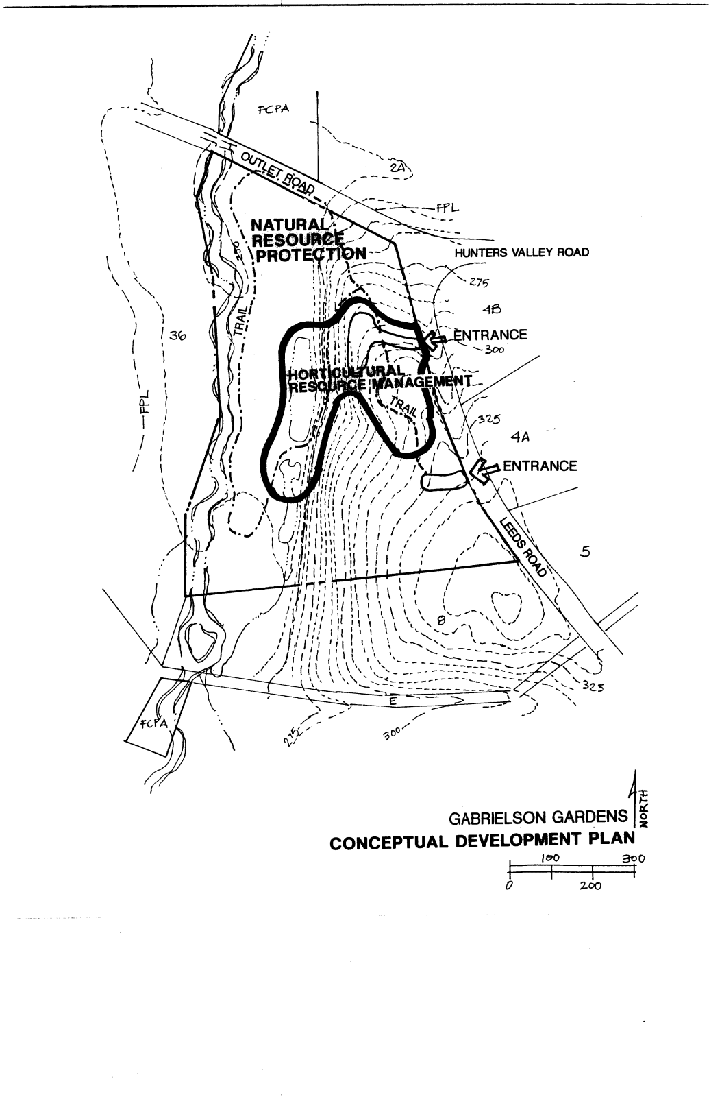
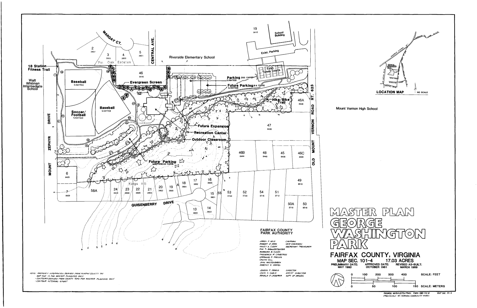
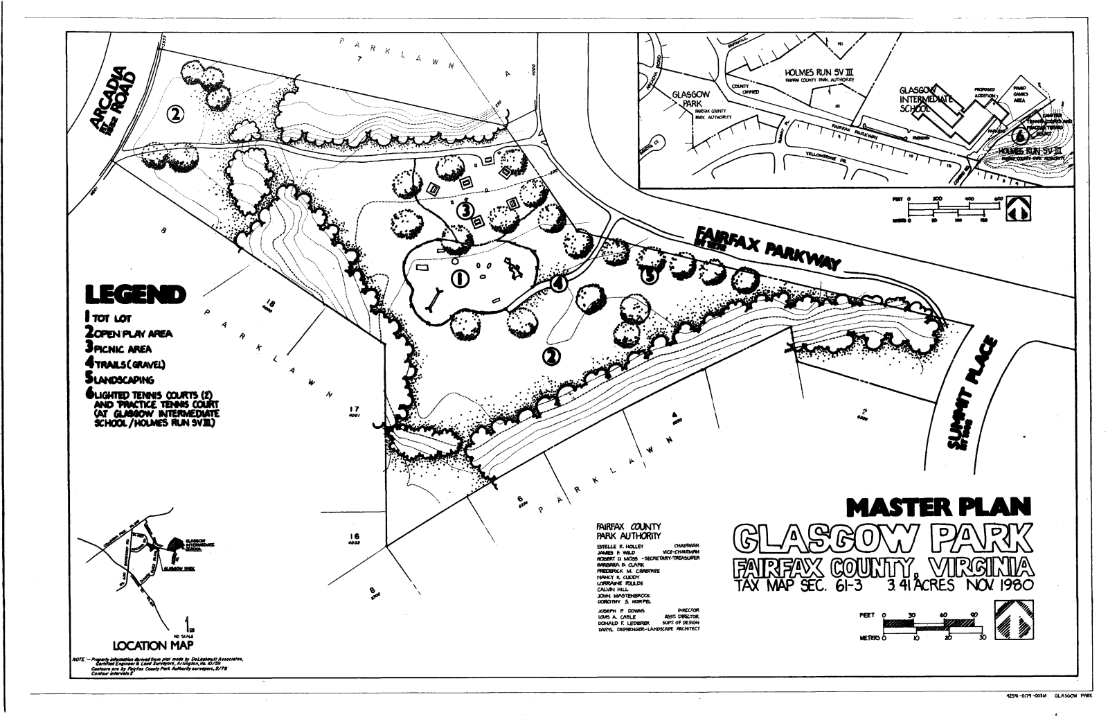
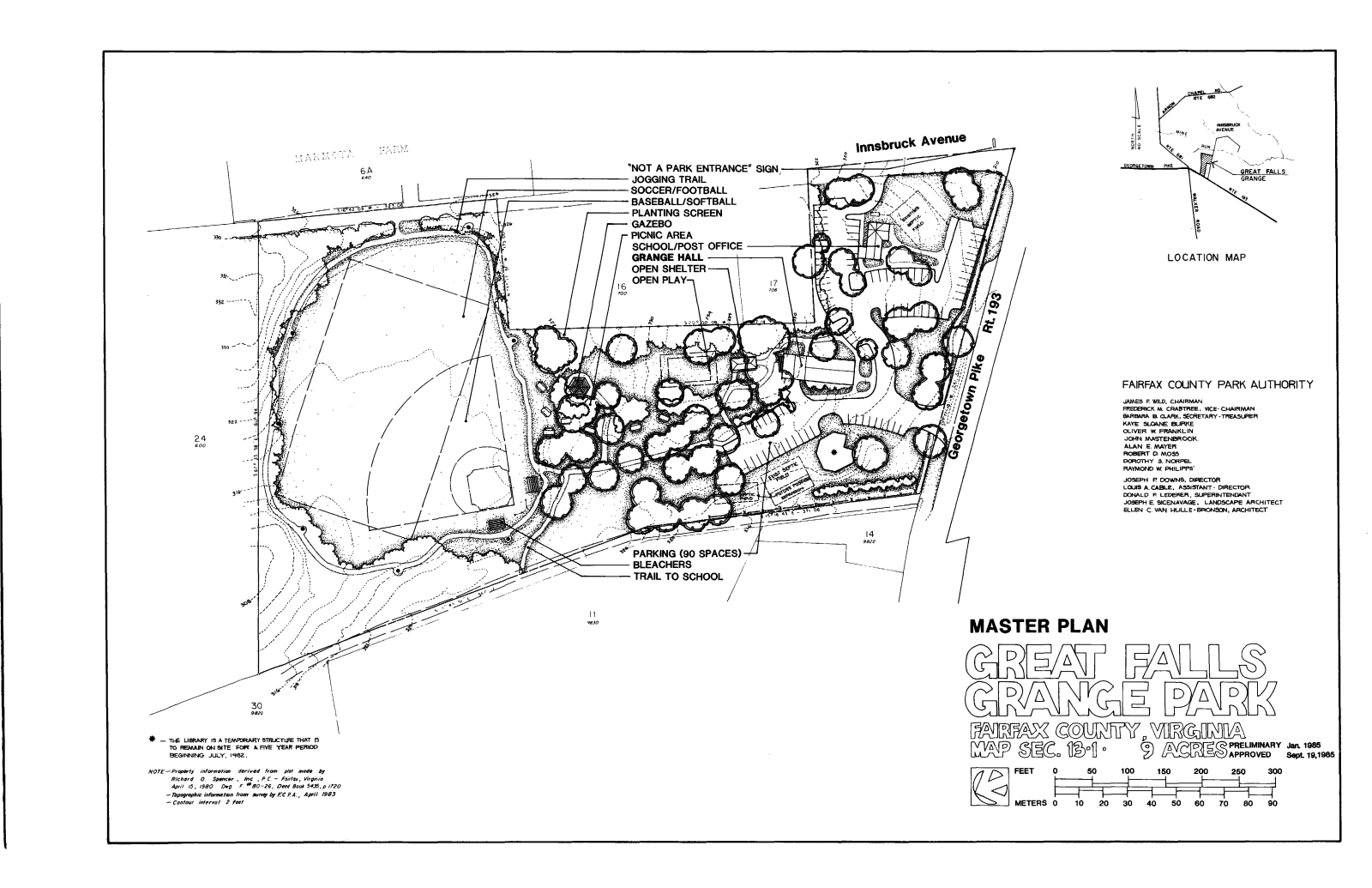
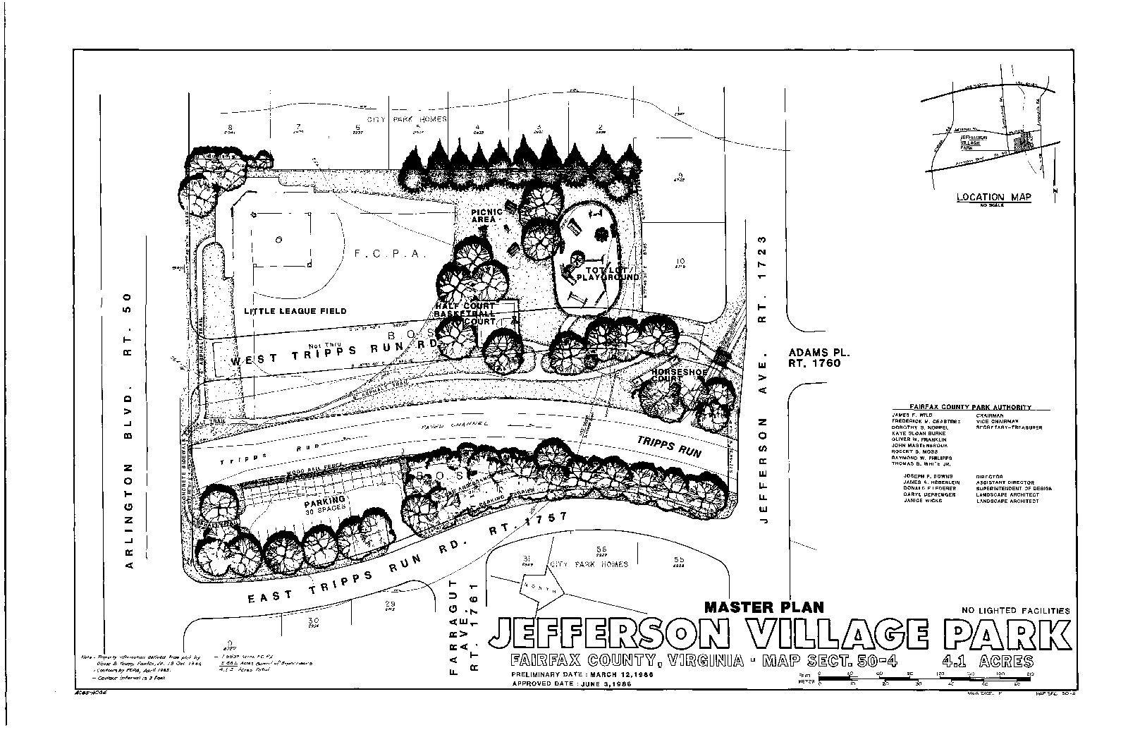
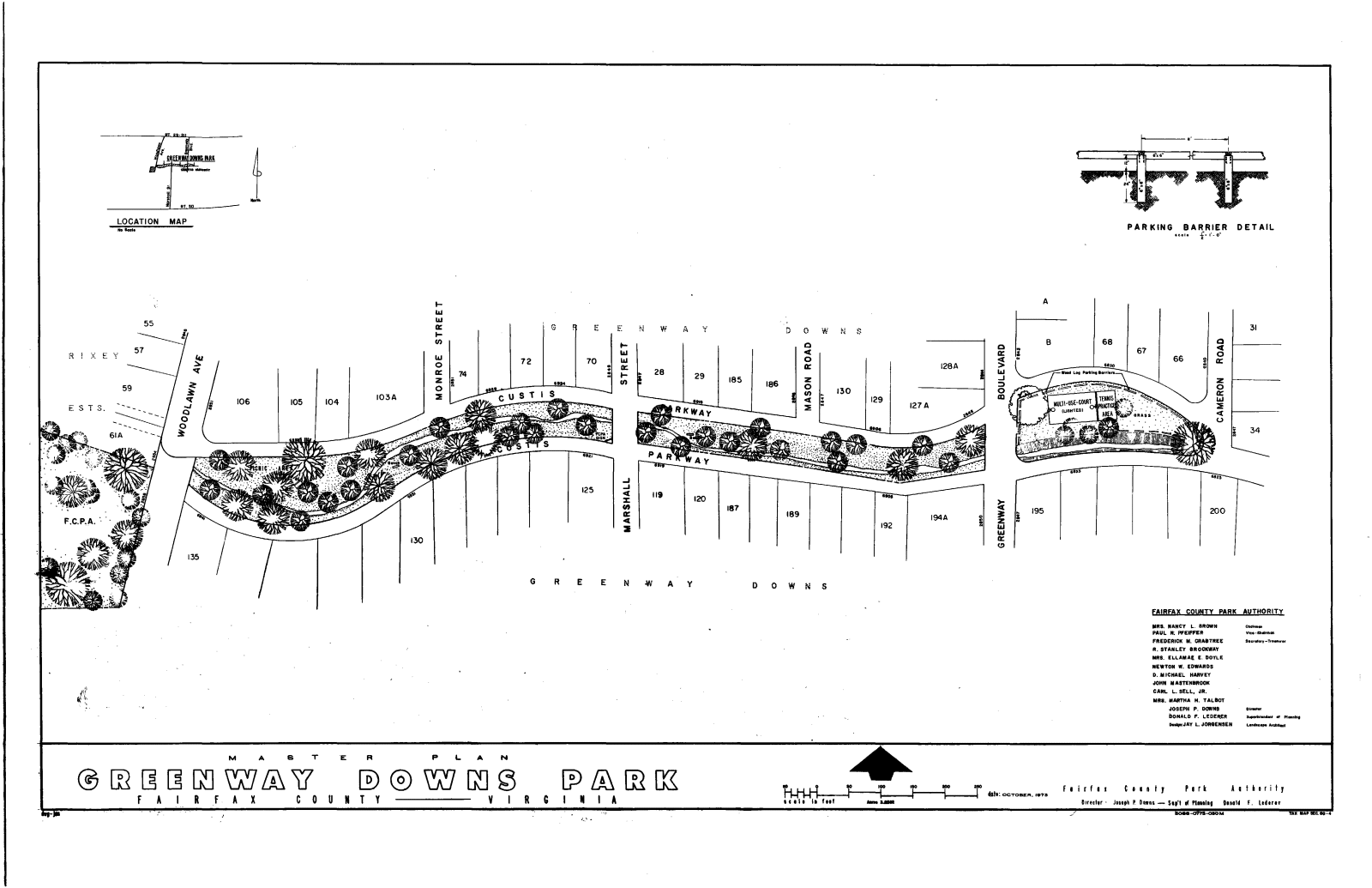
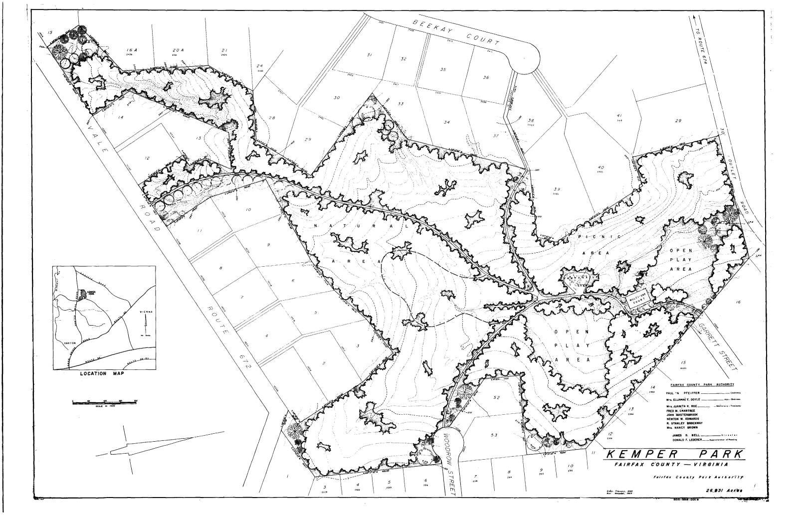
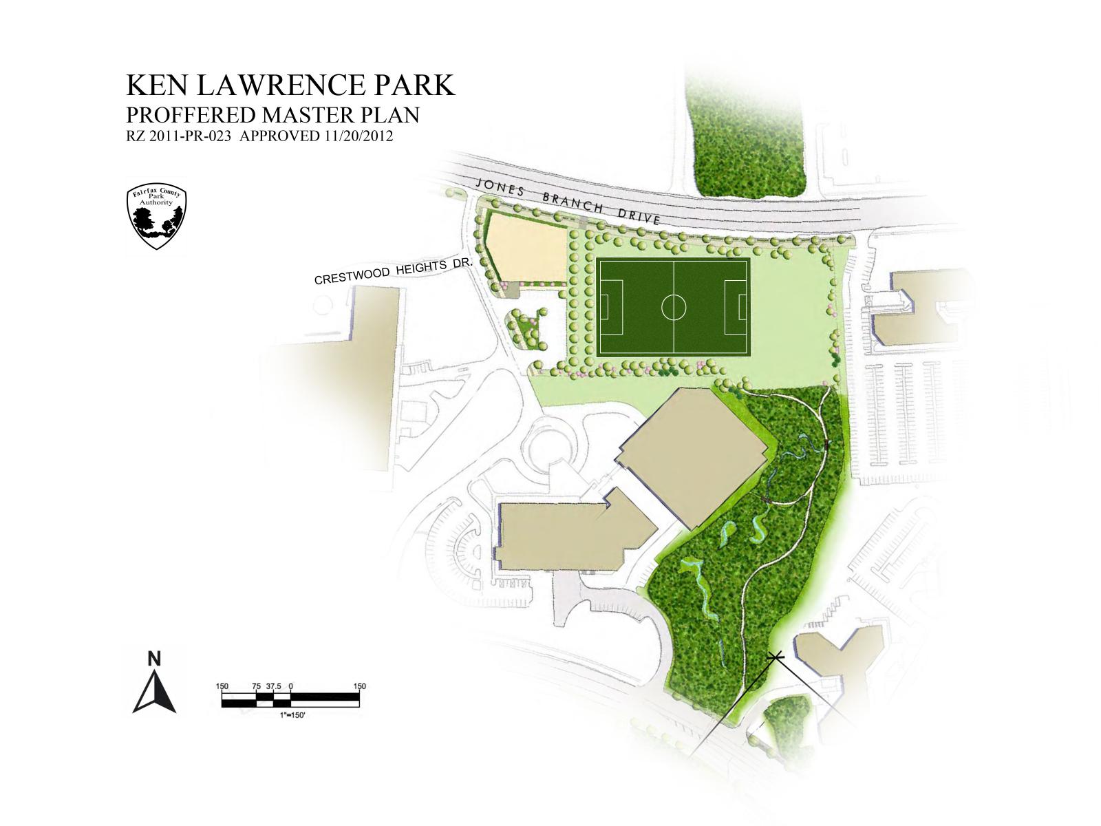
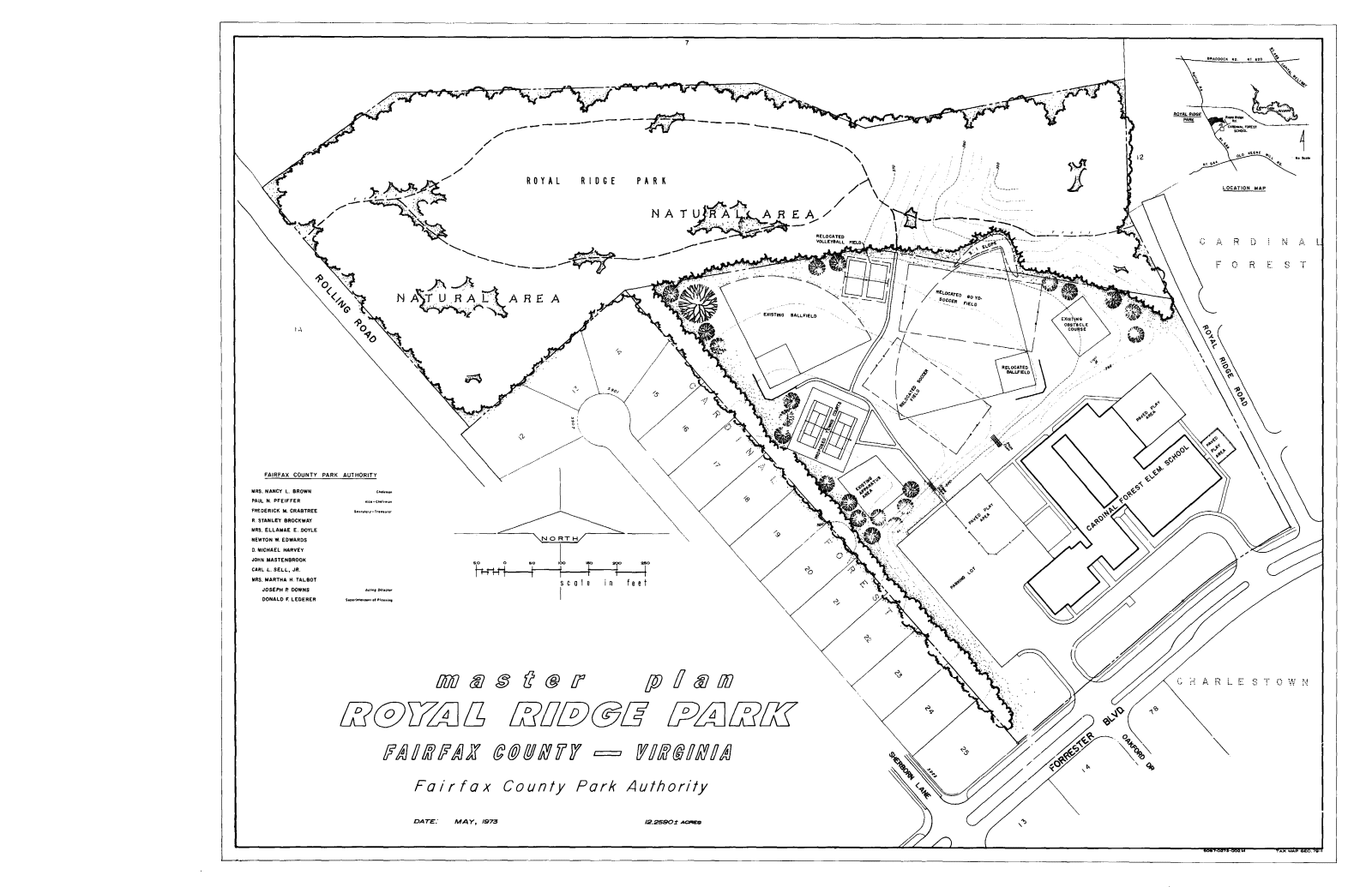
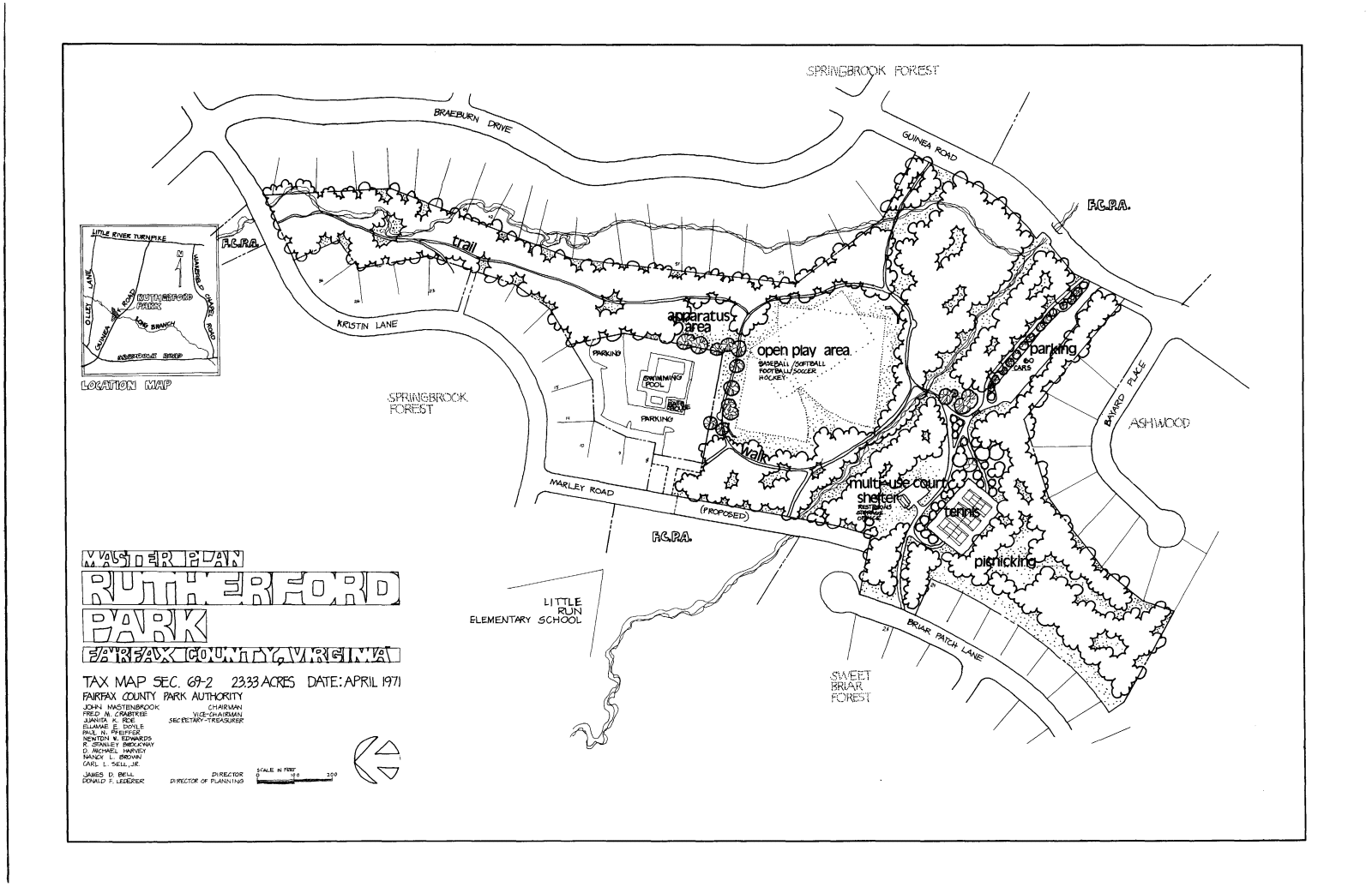
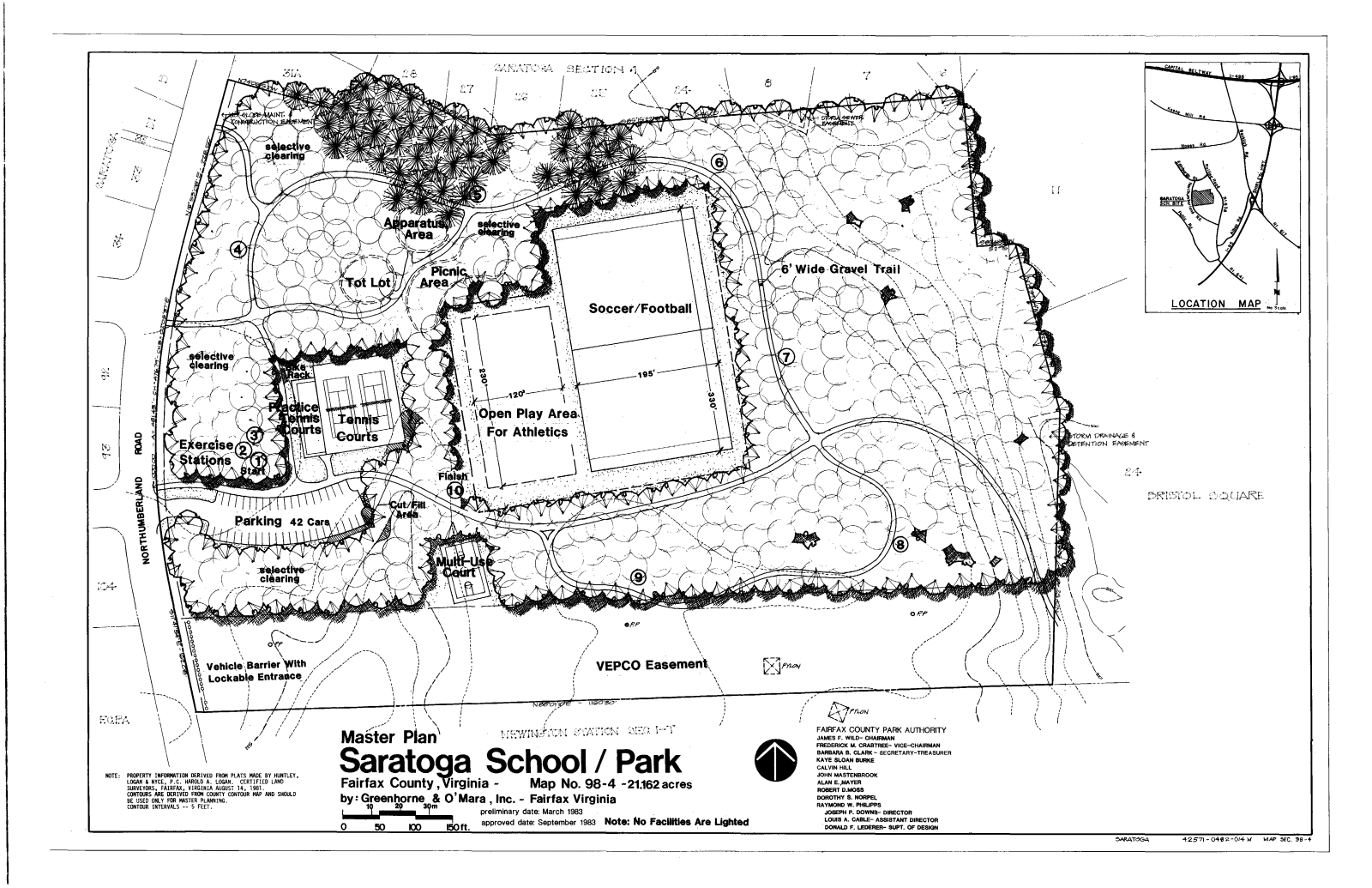
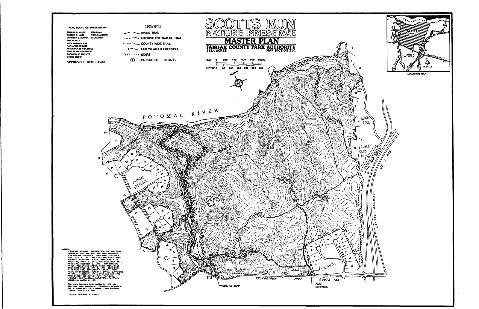
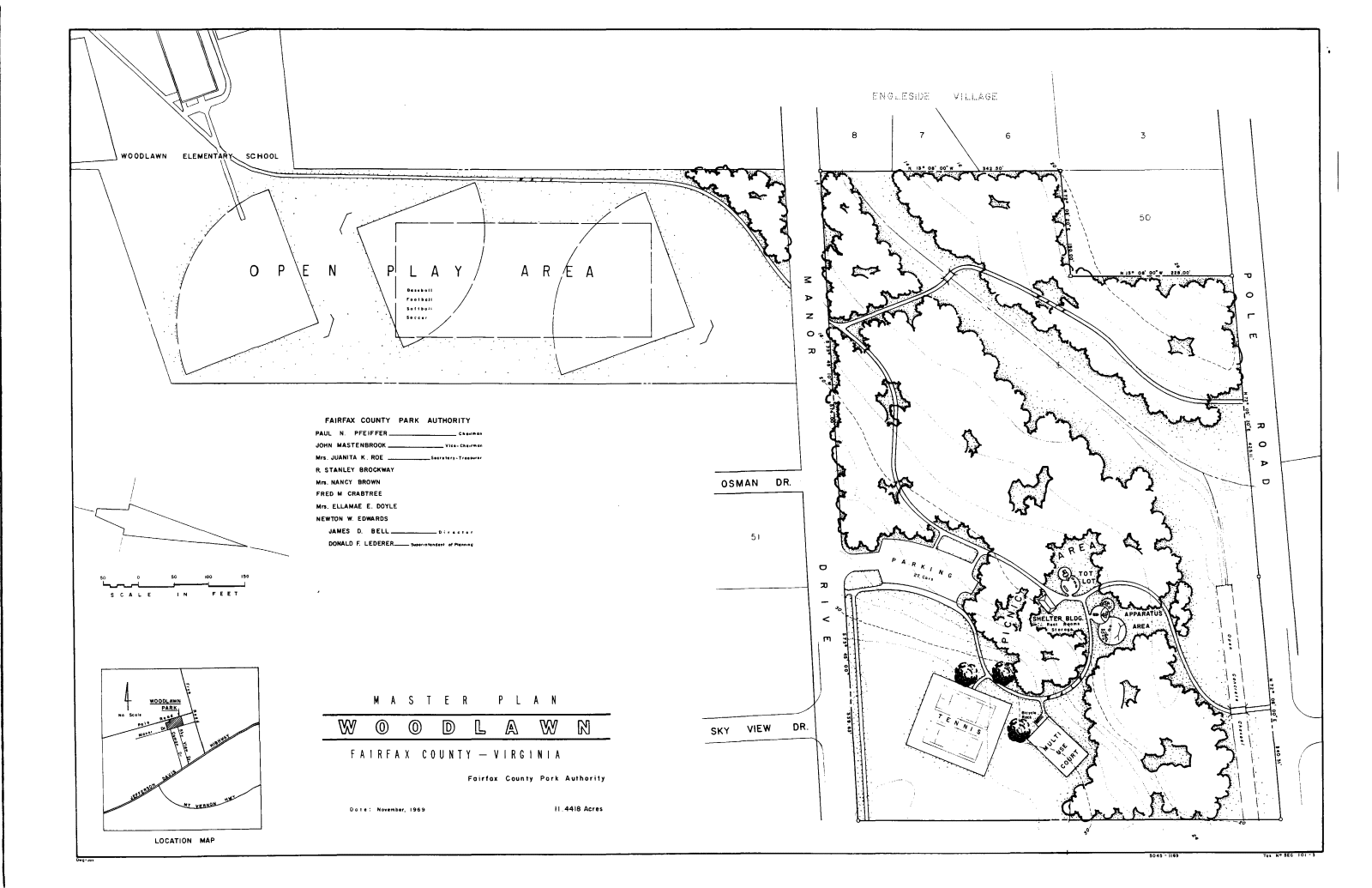
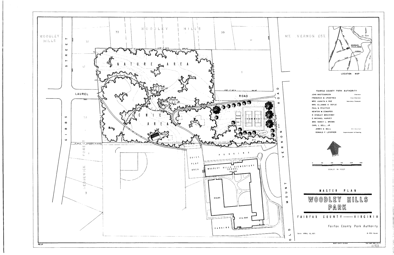
FAIRFAX COUNTY
PARK AUTHORITY

PARK NEWS

FIND A PARK

FIND AN ACTIVITY

ADMINISTRATION

Online Services

Our Government

News and Events

Maps, Facts & Stats

State & Federal

Park Planning and Development: Park Master Plans, Fairfax County Park Authority


Master Plan Archives

The Master Plans are indexed below alphabetically by park name. Each plan is available in two formats, one optimized for viewing online, the other for downloading and printing. Also, several listings include Master Plan or Master Plan Amendment reports. Icons are provided as links to the various versions (see icon key below.)

  • Not all Fairfax County Parks have Master Plans. Some parks have not yet been master planned and others, such as stream valley parks, may never be master planned.
  • A Master Plan represents the long range (10 years or more) plan for the park's development. The Master Plan, and the facilities shown on it, may be built over a period of many years. Therefore, what is shown on the plan may not yet exist at the park site.

Screen resolution image = Screen resolution image for viewing on computer monitor.
Print resolution image = Print resolution image in PDF format for download and printing.
Master Plan Report = Master Plan or Master Plan Amendment Report
Resource Management Plan = Resource Management Plan


A B C D E F G H I
J K L M N O P Q R
S T U V W X Y Z  

[A]

  • ACCOTINK STREAM VALLEY  Master Plan Report
  • ALABAMA DRIVE Screen resolution image   Print resolution image
  • AMBERLEIGH Screen resolution image   Print resolution image
  • AMERICANA
  • ANNANDALE Print resolution image
  • ARROWHEAD Screen resolution image
  • ASHGROVE
  • ASHLAWN Screen resolution image   Print resolution image
  • AZALEA Screen resolution image    Print resolution image
Return to Top of Page


[B]

  • BACKLICK Screen resolution image   Print resolution image
  • BACKLICK STREAM VALLEY
  • BAILEY'S Screen resolution image   Print resolution image
  • BANKS, OLANDER and MARGARET Print resolution image   Master Plan Report
  • BARCROFT KNOLLS
  • BARON CAMERON SCHOOL SITE Screen resolution image   
  • BEL AIR Screen resolution image   Print resolution image
  • BELLE HAVEN
  • BELVEDERE Screen resolution image   Print resolution image
  • BEULAH
  • BLAKE LANE SCHOOL SITE Screen resolution image   Print resolution image
  • BORGE STREET Screen resolution image   Print resolution image
  • BRADDOCK Screen resolution image   Print resolution image
  • BREN MAR Screen resolution image   Print resolution image
  • BRENTWOOD
  • BRIARCLIFF
  • BROOKFIELD Screen resolution image   Print resolution image
  • BROYHILL
  • BROYHILL CREST Screen resolution image   Print resolution image
  • BRUIN (TOWN OF HERNDON) Screen resolution image   Print resolution image
  • BRYN MAWR Screen resolution image   Print resolution image
  • BUCKNELL MANORScreen resolution image  Print resolution image
  • BULL NECK STREAM VALLEY
  • BURGUNDY Screen resolution image   Print resolution image
  • BURKE LAKE & GOLF COURSE Screen resolution image   Master Plan Report
  • BURKE RIDGE
  • BURKE STATION Screen resolution image   Print resolution image
  • BUSH HILL Screen resolution image   Print resolution image
  • BYRON AVENUE
Return to Top of Page


[C]

  • CAMELOT SCHOOL SITE
  • CANTERBURY WOODS Screen resolution image   Print resolution image
  • CARDINAL FOREST Screen resolution image   Print resolution image
  • CARL SANDBURG SCHOOL SITE Screen resolution image   Print resolution image
  • CARNEY PARK Print resolution image
  • CARRLEIGH PARKWAY
  • CENTRE RIDGE
  • CHALET WOODS Screen resolution image   Print resolution image
  • CHANDON (TOWN OF HERNDON) Screen resolution image   Master Plan Report
  • CHANTILLY
  • CHANTILLY LIBRARY SITE
  • CHAPEL ACRES
  • CHAPEL ROAD Screen resolution image   Print resolution image
  • CHESTERBROOK SCHOOL SITE Screen resolution image   Print resolution image
  • CHURCHILL ROAD Screen resolution image   Print resolution image
  • CLARK HOUSE AT BARCROFT MEWS
  • CLARKE'S LANDING
  • CLARKS CROSSING Screen resolution image   Print resolution image
  • CLEMYJONTRI Screen resolution image   Master Plan Report
  • CLERMONT SCHOOL SITE Screen resolution image   Print resolution image
  • COLLINGWOOD Screen resolution image   Print resolution image
  • COLVIN RUN MILL Print resolution image   Master Plan Report
  • COLVIN RUN STREAM VALLEY
  • CONFEDERATE FORTIFICATIONS HISTORIC SITE Screen resolution image   Print resolution image  Master Plan Report
  • COUNTRY CLUB VIEW Screen resolution image   Print resolution image
  • CUB RUN RECENTER (see West County Recenter)
  • CUNNINGHAM Screen resolution image   Print resolution image
Return to Top of Page


[D]

  • DEAD RUN STREAM VALLEY
  • DEERLICK Screen resolution image   Print resolution image
  • DEVONSHIRE Screen resolution image   Print resolution image
  • DIFFICULT RUN STREAM VALLEY
  • DIXIE HILL Screen resolution image   Print resolution image
  • DOGUE CREEK STREAM VALLEY
  • DOLLEY MADISON ESTATES Screen resolution image   Print resolution image
  • DOWDEN TERRACE Screen resolution image   Print resolution image
  • DRANESVILLE TAVERN Screen resolution image   Print resolution image
  • DUNN LORING Screen resolution image   Print resolution image
Return to Top of Page


[E]

  • EAKIN (MANTUA SECTION)  Master Plan Report
  • EAKIN COMMUNITY Screen resolution image   Print resolution image  Master Plan Report
  • EAST BLAKE LANE
  • EDSAL Screen resolution image   Print resolution image
  • ELLANOR C. LAWRENCE Screen resolution image   Print resolution image
  • ELKLICK PRESERVE Resource Management Plan (SEE ALSO SULLY WOODLANDS)
  • EUDORA Screen resolution image   Print resolution image
Return to Top of Page


[F]

  • FAIR RIDGE Screen resolution image   Print resolution image
  • FAIR WOODS
  • FAIRFAX HILLS
  • FAIRFAX PARK SCHOOL SITE
  • FAIRFAX VILLA Screen resolution image   Master Plan Report
  • FALSTAFF Screen resolution image   Print resolution image
  • FARRINGTON
  • FISHER Screen resolution image   Print resolution image
  • FITZHUGH Screen resolution image   Print resolution image
  • FLAG RUN Screen resolution image   Print resolution image
  • FLATLICK STREAM VALLEY
  • FLORIS COMMUNITY Print resolution image
  • FLORIS SCHOOL SITE Screen resolution image   Print resolution image
  • FOLLY LICK STREAM VALLEY
  • FORT HUNT Screen resolution image   Print resolution image
  • FORT WILLARD Screen resolution image   Master Plan Report
  • S. FOSTER INT. SCHOOL SITE Screen resolution image   Print resolution image
  • FOX HUNTERS
  • FRED CRABTREE PARK
    (formerly Fox Mill District Park)
    Screen resolution image   Print resolution image
  • FOX VALLEY
  • FOXSTONE
  • FOXVALE Screen resolution image   Print resolution image
  • FRANCONIA Screen resolution image   Print resolution image
  • FRANCONIA FOREST
  • FRANKLIN FARM Screen resolution image   Print resolution image
  • FRANKLIN GLEN Screen resolution image   Print resolution image
  • FRANKLIN OAKS
  • FRANKLIN WOODS
  • FREEDOM HILL Screen resolution image   Print resolution image
  • FRED CRABTREE PARK
    (formerly Fox Mill District Park)
    Screen resolution image   Print resolution image
  • FROG BRANCH STREAM VALLEY Screen resolution image   Print resolution image
  • FRYING PAN Screen resolution image   Master Plan Report
  • FRYING PAN MEETING HOUSE
  • FRYING PAN STREAM VALLEY
Return to Top of Page


[G]

  • GABRIELSONScreen resolution image  Print resolution image
  • GARNCHAYNE
  • GEORGE MASON
  • GEORGE WASHINGTON Screen resolution image   Print resolution image
  • GLASGOW Screen resolution image   Print resolution image
  • GLEN HILLS
  • GRAND HAMPTONS
  • GREAT FALLS GRANGE Screen resolution image   Print resolution image
  • GREAT FALLS NIKE Screen resolution image   Print resolution image
  • GREEN SPRING GARDENS Screen resolution image   Print resolution image
  • GREENBRIAR Screen resolution image   Print resolution image
  • GREENDALE GOLF COURSE Screen resolution image   Print resolution image
  • GREENFIELD
  • GREENTREE VILLAGE
  • GREENWAY DOWNS Screen resolution image   Print resolution image
  • GREENWAY HEIGHTS Screen resolution image   Print resolution image
  • GRIFFITH Screen resolution image   Print resolution image
  • GRIST MILL Screen resolution image Master Plan Report
  • GROVETON HEIGHTS Screen resolution image   Print resolution image
Return to Top of Page


[H]

  • HARTLAND GREEN Print resolution image
  • HAYCOCK-LONGFELLOW Screen resolution image   Print resolution image
  • HAYFIELD Screen resolution image   Print resolution image
  • HERITAGE HILL
  • HERZELL WOODS
  • HEYWOOD GLEN Screen resolution image   Print resolution image
  • HICKORY FOREST (SEE ALSO SULLY WOODLANDS)
  • HIDDEN POND Screen resolution image   Print resolution image
  • HIDEAWAY Screen resolution image   Print resolution image
  • HISTORIC CENTREVILLE Print resolution image   Master Plan Report
  • HOGGE, BOYD A. AND CHARLOTTE M.  Master Plan Report
  • HOLLIN HALL SCHOOL SITE Screen resolution image   Print resolution image
  • HOLLIN MEADOWS Screen resolution image   Print resolution image
  • HOLLY KNOLL
  • HOLLYWOOD ROAD
  • HOLMES RUN STREAM VALLEY Screen resolution image   Print resolution image
  • HOOES ROAD Screen resolution image   Print resolution image
  • HORSEPEN RUN STREAM VALLEY
  • HOWERY FIELD Screen resolution image   Print resolution image
  • HUNTER VILLAGE
  • HUNTINGTON Screen resolution image   Print resolution image
  • HUNTLEY HISTORIC SITE  Master Plan Report
  • HUNTLEY MEADOWS Screen resolution image   Print resolution image
  • HUNTSMAN Screen resolution image   Print resolution image
  • HUTCHISON SCHOOL SITE Screen resolution image   Print resolution image
  • HYBLA VALLEY Screen resolution image   Print resolution image
Return to Top of Page


[I]

  • IDYLWOOD Screen resolution image   Print resolution image
  • INDIAN RUN STREAM VALLEY
Return to Top of Page


[J]

  • J.E.B. STUART Screen resolution image   Print resolution image  Master Plan Report
  • JAMES LEE SCHOOL SITE Screen resolution image   Print resolution image
  • JEFFERSON DISTRICT Screen resolution image   Print resolution image
  • JEFFERSON MANOR Screen resolution image   Print resolution image
  • JEFFERSON VILLAGE Screen resolution image   Print resolution image
  • JOHN C. & MARGARET K. WHITE GARDENS Print resolution image    Master Plan Report
Return to Top of Page


[K]

  • KEMPER Screen resolution image   Print resolution image
  • KENDALE WOODS Screen resolution image   Print resolution image
  • KENT GARDENS Screen resolution image   Print resolution image
  • KINGS PARK Print resolution image   Master Plan Report
  • KINGS PARK WEST
  • KINGSTOWNE
  • KIRBY
  • KIRK
Return to Top of Page


[L]

  • LAHEY LOST VALLEY Master Plan Report  
  • LAKE ACCOTINK Print resolution image
  • LAKE BRADDOCK SCHOOL SITE
  • LAKE FAIRFAX Screen resolution image   Master Plan Report
  • LAKE MERCER Screen resolution image   Print resolution image
  • LAKESIDE Screen resolution image   Print resolution image
  • LAMOND Screen resolution image   Master Plan Report
  • LANE'S MILLScreen resolution image  Print resolution image
  • LANGLEY FORK Screen resolution image   Print resolution image
  • LARCHMONT Screen resolution image   Print resolution image
  • LAUREL HILL Screen resolution image   Print resolution image  Master Plan Report  Resource Management Plan
  • LAWYERS ROAD Master Plan Report
  • LEE DISTRICT Screen resolution image   Print resolution image  Master Plan Report
  • LEE HIGH Screen resolution image   Print resolution image  Master Plan Report
  • LEE LANDING Screen resolution image   Print resolution image
  • LEEWOOD Screen resolution image   Print resolution image
  • LEMON ROAD Screen resolution image   Print resolution image
  • LEVELLE W. DUPELL Screen resolution image   Print resolution image
  • LEWINSVILLE Screen resolution image   Print resolution image
  • LEXINGTON ESTATES
  • LILLIAN CAREY Screen resolution image   Print resolution image
  • LINCOLNIA Screen resolution image   Print resolution image
  • LINWAY TERRACE Screen resolution image   Print resolution image
  • LISLE Screen resolution image   Print resolution image
  • LITTLE DIFFICULT RUN S.V.
  • LITTLE HUNTING CREEK
  • LITTLE PIMMIT RUN S. V.
  • LOCKMEADE
  • LOFTRIDGE
  • LOISDALE Screen resolution image   Print resolution image
  • LONG BRANCH FALLS
  • LONG BRANCH STREAM VALLEY
  • LORTON Screen resolution image   Print resolution image
  • LURIA Screen resolution image   Print resolution image
  • LYNBROOK
Return to Top of Page


[M]

  • MANASSAS GAP Screen resolution image   Print resolution image
  • MANCHESTER LAKES
  • MARIE BUTLER LEVEN PRESERVE Screen resolution image   Print resolution image
  • MARK TWAIN Screen resolution image   Print resolution image
  • MARTIN LUTHER KING, JR. Screen resolution image   Print resolution image
  • MASON DISTRICT Screen resolution image   
  • MASON NECK WEST Screen resolution image   Print resolution image
  • MASONVILLE Screen resolution image   Print resolution image
  • MCDANNALD HOUSE
  • MCLEAN CENTRAL Screen resolution image   Print resolution image  
  • MCLEAN HAMLET Screen resolution image   Print resolution image
  • MCLEAN HIGH
  • MCLEAN HUNT ESTATES Screen resolution image   Print resolution image
  • MCLEAN KNOLLS
  • MERRILEE PARK (see Harland Green Park)
  • MIDDLE RUN STREAM VALLEY
  • MIDDLERIDGE Screen resolution image   Print resolution image
  • MONTICELLO
  • MONTICELLO WOODS
  • MOSBY WOODS Screen resolution image   Print resolution image
  • MOUNT AIR Master Plan Report
  • MOUNTAIN ROAD DISTRICT (SEE ALSO SULLY WOODLANDS)
  • MT. EAGLE Screen resolution image   Print resolution image
  • MT. ROYAL Screen resolution image   Print resolution image
  • MT. VERNON DISTRICT Screen resolution image   Print resolution image
  • MT. VERNON MANOR Screen resolution image   Print resolution image
  • MT. VERNON WOODS Screen resolution image   Print resolution image
  • MT. ZEPHYR Screen resolution image   Print resolution image
  • MUDDY HOLE FARM Screen resolution image   Print resolution image
  • MUNSON HILL Screen resolution image   Print resolution image
Return to Top of Page


[N]

  • NAVY VALE
  • NEWINGTON COMMONS
  • NEWINGTON HEIGHTS Screen resolution image   Print resolution image
  • NORTH HILL PARK Master Plan Report
  • NORTH SPRINGFIELD
  • NOTTOWAY Screen resolution image   Print resolution image  Master Plan Report
Return to Top of Page


[O]

  • OAK HILL Screen resolution image   Print resolution image
  • OAK MARR Screen resolution image   Print resolution image  Master Plan Report
  • OAKTON COMMUNITYPrint resolution image  Master Plan Report
  • OLD CENTREVILLE ROAD Screen resolution image   Print resolution image
  • OLD COLCHESTER Resource Management Plan
  • OLD DOMINION SCHOOL SITE
  • OLDE FORGE Screen resolution image   Print resolution image
  • OLNEY Screen resolution image   Print resolution image
  • ORANGE HUNT ESTATES Screen resolution image   Print resolution image
  • OSSIAN HALL Screen resolution image   Print resolution image  Master Plan Report
  • OX HILL BATTLEFIELD PARK Screen resolution image   Print resolution image  Master Plan Report
Return to Top of Page


[P]

  • PARKLAWN Screen resolution image   Print resolution image
  • PATRIOT PARK
    (formerly Popes Head Estates)
    Screen resolution image   Print resolution image  Master Plan Report
  • PAUL SPRINGS STREAM VALLEY
  • PETERSON LANE Screen resolution image   Print resolution image
  • PIMMIT HILLS Screen resolution image   Print resolution image
  • PIMMIT RUN STREAM VALLEY
  • PIMMIT VIEW Screen resolution image   Print resolution image
  • PINE RIDGE Screen resolution image   Master Plan Report
  • PINE SPRING Screen resolution image   Print resolution image
  • PINECREST GOLF COURSE Screen resolution image   Print resolution image
  • PINEY BRANCH STREAM VALLEY
  • PLEASANT HILL
  • POBURN WOODS
  • POE TERRACE Screen resolution image   Print resolution image
  • POHICK ESTATES Screen resolution image   Print resolution image
  • POHICK SCHOOL SITE
  • POHICK STREAM VALLEY
  • POLE ROAD Screen resolution image   Print resolution image
  • POPES HEAD Screen resolution image   Print resolution image
  • POPLAR FORD (SEE ALSO SULLY WOODLANDS)
  • PATRIOT PARK
    (formerly Popes Head Estates)
    Screen resolution image   Print resolution image  Master Plan Report
  • POPES HEAD STREAM VALLEY
  • POPLAR TREE Screen resolution image   Print resolution image
  • POTOMAC HILLS
  • PROVIDENCE Screen resolution image   Print resolution image
Return to Top of Page


[Q]

  • ROCK HILL DISTRICT (formerly Quinn Farm) Master Plan Report      
Return to Top of Page


[R]

  • RAGLAN ROAD
  • RED FOX FOREST
  • RESTON NORTH Screen resolution image   Print resolution image
  • RICHARD W. JONES Screen resolution image   Print resolution image
  • RIDGEVIEW Screen resolution image   Print resolution image
  • RIVERBEND Screen resolution image   Print resolution image
  • ROCK HILL DISTRICT (formerly Quinn Farm) Master Plan Report
  • ROCKY RUN STREAM VALLEY
  • ROLLING FOREST
  • ROLLING VALLEY WEST Screen resolution image   Print resolution image
  • ROLLING WOOD SCHOOL SITE Screen resolution image   Print resolution image
  • ROLLING WOODS ESTATES
  • ROUNDTREE Screen resolution image   Print resolution image
  • ROSE LANE Screen resolution image   Print resolution image
  • ROYAL LAKE Screen resolution image   Print resolution image
  • ROYAL RIDGE Screen resolution image   Print resolution image
  • RUTHERFORD Screen resolution image   Print resolution image
Return to Top of Page


[S]

  • SANDY RUN STREAM VALLEY
  • SARATOGA Screen resolution image   Print resolution image
  • SCOTTS RUN NATURE PRESERVE Screen resolution image   Print resolution image
  • SCOTTS RUN STREAM VALLEY
  • SHAKER WOODS
  • SILAS BURKE Screen resolution image   Print resolution image
  • SILVERBROOK
  • SLEEPY HOLLOW Screen resolution image   Print resolution image
  • SOUTH KINGS FOREST
  • SOUTH LAKES DRIVE Screen resolution image   Print resolution image
  • SOUTH RUN DISTRICT Screen resolution image   
  • SOUTH RAILROAD STREETScreen resolution image  Print resolution image  Master Plan Report
  • SOUTHGATE
  • SPRING HILL Screen resolution image   Print resolution image  Master Plan Report
  • SPRING LANE Screen resolution image   Print resolution image
  • SPRINGFIELD FOREST
  • SPRINGVALE Screen resolution image   Print resolution image
  • STANTON Screen resolution image   Print resolution image
  • STONEYBROOKE Screen resolution image   Print resolution image
  • STRATFORD LANDING Screen resolution image   Print resolution image
  • STRATTON WOODS Screen resolution image   Print resolution image  Master Plan Report
  • STUART ROAD Screen resolution image   Print resolution image
  • SUGARLAND RUN STREAM VALLEY
  • SULLY Print resolution image   Master Plan Report
  • SULLY WOODLANDSScreen resolution imagePrint resolution imageMaster Plan Report
  • SURREY SQUARE
  • SYMPHONY HILLS
Return to Top of Page


[T]

  • TAMARACK Screen resolution image   Print resolution image
  • TARA VILLAGE
  • TATTERSALL
  • TIMBERLY
  • TOLLBROOK RIDGE
  • TOWERS Screen resolution image   Master Plan Report
  • TRAILSIDE
  • TURNER FARM Master Plan Report
  • TWIN LAKES GOLF COURSE Screen resolution image   Print resolution image
  • TWINBROOK ROAD
  • TYLER Screen resolution image   Print resolution image
  • TYSONS WOODS Screen resolution image   Print resolution image
  • TYSONS/PIMMIT Screen resolution image   Print resolution image
Return to Top of Page


[U]

  • UNIVERSITY
Return to Top of Page


[V]

  • VALLEY CREST Screen resolution image   Print resolution image
  • VERNON HEIGHTS
  • VILLA D'ESTE Screen resolution image   Print resolution image
  • VILLA LEE
  • VIRGINIA HILLS SCHOOL SITE
Return to Top of Page


[W]

  • WAKEFIELD Screen resolution image
  • WALT WHITMAN SCHOOL SITE
  • WASHINGTON MILL Screen resolution image   Print resolution image
  • WAVERLY Screen resolution image   Print resolution image
  • WEST COUNTY RECENTER  Master Plan Report
  • WEST OX ROAD Screen resolution image   Print resolution image
  • WEST SPRINGFIELD Screen resolution image   Print resolution image
  • WEST SPRINGFIELD VILLAGE
  • WESTGATE Screen resolution image   Print resolution image
  • WESTGROVE
  • WESTLAWN SCHOOL SITE Screen resolution image   Print resolution image
  • WHITE OAKS Screen resolution image   Print resolution image
  • WHITE HORTICULTURAL PARK See John C & Margaret K White Gardens
  • WICKFORD Screen resolution image   Print resolution image
  • WILBURDALE Screen resolution image   Print resolution image
  • WILLIAMSBURG MANOR Screen resolution image   Print resolution image
  • WILLOW WOODS Screen resolution image   Print resolution image
  • WILTON WOODS SCHOOL SITE
  • WINDERMERE
  • WOLF TRAILS Screen resolution image   Print resolution image
  • WOLFTRAP STREAM VALLEY
  • WOODLAWN Screen resolution image   Print resolution image
  • WOODLEY HILLS Screen resolution image   Print resolution image
  • WOODGLEN LAKE Print resolution image   Master Plan Report


Contact Us: General (Office of Public Affairs) | Technical (Web Administrator) | Directed Inquiries (County Agencies)
Phone: County Main Number - 703-FAIRFAX (703-324-7329), TTY 711 | County Phone Listing

ADA Accessibility | Website Accessibility
Awards | FOIA | Mobile | Using this Site | Web Disclaimer & Privacy Policy | Get Adobe Reader
Official site of the County of Fairfax, Virginia, © Copyright 2011
Verizon Cybertrust Security Certified Logo;

Website Survey Website Survey    Globe with various flags representing Web site language translations   Language Translations

Return to Graphic Version