

Land Development Services Alert:
The public may now sign up for notifications about parking adjustment requests submitted to Land Development Services. The Board of Supervisors (Board) approved the repeal and replacement of parking requirements which took effect on Jan. 1, 2024. The Board also requested notifications to allow members of the public to receive alerts regarding parking adjustment requests.
This notification system enhances transparency of our processes and provides citizens access to records to allow an opportunity to comment or seek additional information on proposed parking adjustments. The parking adjustments notification list was made available to the public in Jan. 2024, and it is updated monthly. If you are interested in being notified about parking adjustment submittals, you can sign up for the notification list here. Thank you very much for your interest in this topic area.
The Department of Land Development Services’ introduced an online comprehensive permit library of over 60+ help guides for all record types available in the Planning and Land Use system (PLUS). Within the permit library, customers will find a page devoted to each record type providing guidance through the building and site application and approval process.
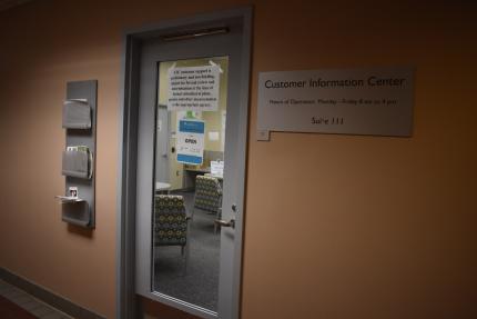
Land Development Services (LDS) offers many customer service opportunities, both in-person and virtually. Please do not hesitate to reach out with any pertinent land development-related questions or concerns. We are happy to assist you!
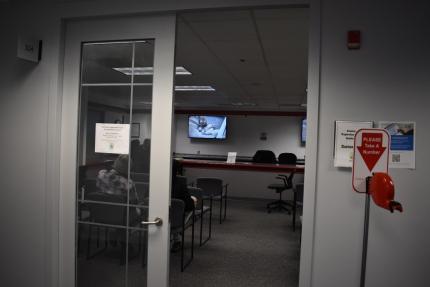
If you prefer face-to-face interactions with staff, in-person customer service is available every day at the Herrity Building. Here are the locations, services and hours of our in-person customer service:
Want to know what land development projects are possible on your property? Need to talk to someone about your plans?
Need help applying for a permit and navigating the Planning and Land Use System (PLUS)?
Do you need to pay for LDS-related fees?
Please note that visitors may not be added to in-person queues past 3:45 p.m. Please plan to arrive before that time.
If you prefer the convenience of calling, emailing or meeting virtually from the comfort of your home or office, our virtual customer service options are detailed on our Meet With Staff webpage.
The three main causes of flooding in Fairfax County include the following conditions:
To identify these conditions, Land Development Services (LDS) staff developed two new Flood Risk Analysis Tools as part of the Floodplain Viewer and the Drainage Basin Delineation Tool. The new data layers:
These two layers are the result of analysis performed on a Light Detection and Ranging (LiDAR) derived Bare Earth Digital Elevation Model (DEM).
The Potential Sump Conditions layer highlights locations of sumps, or bowl-shaped depressions, where water pools and is unable to drain until the depression fills and overtops. Where structures are within such sump areas those structures may be subject to flood risk. Flooding can also occur when there is a stormwater inlet in the sump, and it becomes overwhelmed due to the magnitude of incoming flows. This layer includes the volume and three-dimensional surface area of the sump areas.
The Overland Relief Flow Accumulation Layer helps to visualize the natural overland runoff flow paths, including paths into and out of sumps. The flow path is strictly based on the bare earth elevation. This provides a clear picture of where the water flows when there is no stormwater management in place, or the infrastructure is overwhelmed.
Fairfax County uses the Flood Analysis Tools to better assess and review flood risk. Applications for the tools include:
The Potential Sump Conditions and Overland Relief Flow Accumulation layers can be found in Floodplain Viewer and the Drainage Basin Delineation Tool. The Potential Sump Conditions layer is available for download in the Fairfax County Open Geospatial Data site. The image service for the Overland Relief Flow Accumulation is located on our server and can be added to ArcGIS Pro and ArcMap. Please visit the Flood Risk Analysis Tools story map for more information on these new datasets.
Please review the Fairfax County GIS Division disclaimer. These layers are provided to improve awareness of flood risk but are not engineering analysis nor hydraulic analysis.
For questions about any LDS GIS apps or data, including the two new layers, please email LDS GIS.
Land Development Services (LDS) recently launched a new Proffer/Development Condition module in the Planning and Land Use System (PLUS). Proffers and development conditions are additional requirements to mitigate the impacts of an application (e.g., a development condition for a turn lane or traffic signal necessary to mitigate the impacts of the traffic pattern generated by that development). Proffers and development conditions are established during the Board of Supervisors rezoning approval process and other types of entitlement cases processed by the Department of Planning and Development (DPD). Many proffers and development conditions must be addressed prior to or at the time of certain construction milestones. LDS verifies and confirms compliance of any proffers that affect site or building plans and permits issued by LDS.
The Proffer/Development Condition module in PLUS will help support tracking proffers and development conditions approved on entitlement cases, and significantly, will readily relate those conditions to associated site and building records. This system will ensure that applicable proffers and development conditions are flagged at key milestones and appropriately monitored and enforced by staff, furthering our goal of managing all development related activities in one comprehensive system.
While the Proffer/Development Condition module is now visible to customers in PLUS, it is in a beta testing mode. Specific entitlement cases will be piloting the module, in close coordination with staff from LDS and the DPD. We expect to open up the Proffer/Development Condition module to all new entitlement cases in the coming months. Until then, unless you’ve been contacted by staff for participation in the pilot, please continue to follow the proffer compliance process outlined here: https://www.fairfaxcounty.gov/landdevelopment/proffer-compliance. Once the beta testing mode is complete and a date has been confirmed for the full release of the Proffer/Development Condition module, additional updates and information will be provided.
![]() County staff continue to implement additional improvements to the Planning and Land Use System (PLUS) to serve you better. Check out these new PLUS fixes for Land Development Services (LDS) customers.
County staff continue to implement additional improvements to the Planning and Land Use System (PLUS) to serve you better. Check out these new PLUS fixes for Land Development Services (LDS) customers.
|
PLUS Enhancement |
LDS Customer Benefit |
|
Updates to Building |
|
|
Added help text to commercial and residential trades permit applications. |
Added help text to better inform customers about what LDS needs to see in the “estimated cost of construction” and “estimated cost of materials” fields as part of the permit application process. |
|
Added links to required documents for residential building records. |
Added instructional text and links to the residential building records that require plans and/or documents submitted through the Digital Plan Room to better explain why the form is required. Provided a link that will take customers directly to the specific required form, so customers don’t have to search for it outside of PLUS. |
|
Made the critical structures record available when the parent permit is issued. |
This allows for the critical structures record to be created if there is a revision or permit amendment that changes the requirements. |
|
Updated the application process for non-residential use permits (Non-RUPs). |
Updated Non-RUP application process by including additional questions and creating the Non-RUP number before payment. |
|
Updates to Site |
|
|
Added instructional text to water quality impact assessment (WQIA) drop down values on the record intake form. |
Provided more information for each code item to help customers verify they are submitting WQIA applications under the correct code reference. |
|
Added standard Conditions of Approval to site parent record for major plans at plan issuance. |
Added standard Post-Approval conditions to major site records at plan issuance. This allows developers to track conditions for bond release under the parent plan in addition to the bond record. |
|
Corrected email notifications for prescreen corrections on revisions. |
Applicants receive an email notification from PLUS when the record is set to “Waiting for Information” by intake staff. This allows applicants to quickly address intake comments. |
|
Updated site approval stamps. |
Site records have a consistent approval stamp across most plan types which better demonstrates the department issuing the approval. |
![]() We welcome your feedback on future PLUS enhancements. If you have ideas to improve the system, please take a moment to enter them here: LDS Customer PLUS Feedback Form.
We welcome your feedback on future PLUS enhancements. If you have ideas to improve the system, please take a moment to enter them here: LDS Customer PLUS Feedback Form.
![]() Fairfax County Government offices, including Land Development Services (LDS), will be closed after noon on Friday, Dec. 22. Offices will also be closed all day on Monday, Dec. 25, 2023, and Monday, Jan. 1, 2024.
Fairfax County Government offices, including Land Development Services (LDS), will be closed after noon on Friday, Dec. 22. Offices will also be closed all day on Monday, Dec. 25, 2023, and Monday, Jan. 1, 2024.
LDS Customer Information Center and Customer Experience Team counters will be closed all day on Friday, Dec. 22. However, staff will be available from 9:15 a.m. to noon to respond to questions via phone or email on Friday, Dec. 22.
The Planning and Land Use System (PLUS) will remain accessible to customers throughout the closure, but staff will not be available to respond to questions in person or via phone or email.
Happy Holidays from all of us at Land Development Services! We look forward to working with you in the new year!

County staff continue to implement additional improvements to the Planning and Land Use System (PLUS) to serve you better. Check out these new PLUS fixes for Land Development Services (LDS) customers.
PLUS Enhancement |
LDS Customer Benefit |
Updates to Building |
|
|
Update plan room logic for commercial building records for new commercial building (BLDC), commercial alteration (ALTC), and commercial miscellaneous (MISCC) record types. |
The plan room was adjusted to no longer require plans/documents if there is a related parent or Masterfile record. |
|
Correct an address issue with the Cross Connections report. |
The property address is now being properly displayed on the Cross Connections report. |
|
Correct an address issue with the Statement of Special Inspections (SSI) form. |
The owner section of the SSI form was updated to reflect the correct owner’s address. |
|
Update the residential certificate of occupancy. |
The certificate of occupancy was updated to include code required fields and to include the Zoning Administrator’s signature. |
|
Update building inspections email notifications. |
Building inspections emails have been modified to better reflect the inspections process and next steps for applicants. |
Updates to Site |
|
|
Update floodplain notice of violation produced from complaint records. |
Updated report provides a clear and concise notice for customers and staff. |
|
Remove work location map from records page and replace with address. |
Remove the work location map and replaced it with an address to provide a cleaner looking screen for customers and prevent delays with loading content. |
|
New question for subdivision grading plan (SDGP) and site plan grading plan (SPGP) revision records. |
There is now a question during the application process asking whether the revision being submitted has been confirmed to qualify for a minor revision. If so, it will then correctly assess the $108 review fee instead of a $432 fee. |
|
Update plan room disciplines to indicate minor addition for resource protection area waiver (WRPA) review. |
Customers have a clearer picture of the correct agency/department providing a review comment. |
![]() We welcome your feedback on future PLUS enhancements. If you have ideas to improve the system, please take a moment to enter them here: LDS Customer PLUS Feedback Form.
We welcome your feedback on future PLUS enhancements. If you have ideas to improve the system, please take a moment to enter them here: LDS Customer PLUS Feedback Form.
 Effective Dec. 29, 2023, LDSNET, a legacy land development system, will no longer be available for use. Customers may access land development records through PLUS (the Planning and Land Use System). PLUS serves as Fairfax County’s central platform for customers to complete building, zoning, permitting and other land development processes. If you are unable to find a land development record in PLUS, you will be able to locate your record at the Land Development Information History webpage.
Find important information and instructions for Land Development Service (LDS)-related records on the Permit Library | Land Development Services (fairfaxcounty.gov) page.
Visit the PLUS webpage for additional information about PLUS.
 Staff from the Department of Land Development Services (LDS) and the Department of Planning and Development (DPD) conducted a 90-day pilot program beginning in August to test a process change that would reduce the review period for residential deck permits from about ten days to three-business days. The pilot project was successful, and the new process has been implemented as a permanent change; comprehensive residential deck reviews are now completed within three-business days. LDS and DPD staff have been able to review applications associated with residential deck permits within three-business days of completed application submission. This includes first submission applications as well as resubmissions. This change will streamline the permitting process for the over 2,000 residential deck permits that are issued on average each year.
This does not include deck projects proposing encroachment into the Resource Protection Area (RPA) and/or the floodplain as those require separate, and more technical, site review. For more information on floodplain and RPA submission requirements, visit our Plan Ahead page.
Current review times for non-residential deck permits and other project types can be found at Land Development Metrics.
For more information about residential deck projects please visit the LDS Permit Library or call 703-222-0801.