

The Fairfax County Planning Commission recommended approval on Feb. 22 for the proposed, new land use plan that supports walking, biking, and a bus rapid transit system on Richmond Highway.
Commissioners adopted 83 changes to the county’s original draft of the land use plan. More than 70 of these revisions were requested by the 14 community, environmental and historical groups that testified on the proposal.
For the past two years, county officials have been working to update the land use plan for the 7.5-mile corridor as a first needed step towards building the future bus system.
The proposal also supports two future Metro stations along the highway, extending the rail system’s Yellow line to Hybla Valley.
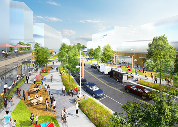
Overall, the plan calls for concentrating more mixed use development, especially residential, within a half mile around the nine bus rapid transit—or BRT—stations. It also envisions new ways to get around, providing continuous walking and bike paths along the corridor as well as the BRT system.
While the total amount of new development proposed isn’t significantly more than the current land use plan, the proposal calls for more residential development. In total, the plan foresees a maximum of 18,000 housing units and 8.5 million square feet in non-residential development.
New, interconnected park spaces are envisioned along the corridor. The parks will be strategically located at each of the BRT stations and distributed throughout the station areas, providing places for people to recreate and enjoy nature and opportunities to reference historic resources through their design. The proposal also features two new, innovative concepts for open space called livability and ecological spines. These spines are continuous park spaces that are integrated with streets and buildings.
Livability spines act as alternative main streets to Richmond Highway, creating destinations for shopping, recreation and gathering outdoors. These spines integrate local streets with pedestrian and bike paths, linear parks, plazas and retail and restaurants.
Ecological spines highlight the streams that were diverted into channels or underground tunnels before modern environmental regulations. Many of these currently hidden streams will be “daylighted,” incorporating them into the street design. These spines could offer boardwalks, seating, gathering areas, trails, fitness equipment and other passive recreation spaces, as well as help make connections to existing residential neighborhoods.
The corridor is home to six community business centers, areas planned for future development.The proposal concentrates most of the future growth into four of these centers: Penn Daw, Beacon/Groveton, Hybla Valley/Gum Springs and Woodlawn. The densest development would be focused in Beacon/Groveton and Hybla Valley, the locations for the two future Metro stations.
Today, the four centers are dominated by suburban retail and strip malls. Under the plan, they would be transformed into places with distinct characters and identities:
- Penn Daw: Encompassing the crossroads where North and South Kings Highways meet Richmond Highway, this center is planned as a transit gateway due to its proximity to the Huntington Metro. It is planned for 2,910 housing units, 2,663 jobs and 915,000 square feet in non-residential development. Buildings will reach up to 15 stories along the highway closest to the BRT station. This center will feature a livability spine on the east side of the highway.
- Beacon/Groveton: It is envisioned as the urban town center and focal point or the entire corridor. Beacon/Groveton is planned for approximately 1.3 million square feet in non-residential development, 4,200 housing units and 3,560 jobs. With a Metro station, the plan allows for an additional 1.8 million square feet in non-residential development. Because it is a town center, Beacon Groveton is planned to have the tallest buildings along the corridor, reaching up to 22 stories closest to the BRT station, taking advantage of the potential views to Old Town Alexandria and Washington D.C. On the west side of the Richmond Highway, a central civic plaza will connect to the BRT station, and this plaza is intended to host large community events like festivals, farmers markets and outdoor performances. The plaza will also link to a livability spine.
- Hybla Valley/Gum Springs: This center contains ecological resources, including streams that connect to Huntley Meadows Park, and a rich historical legacy, including the Gum Springs community. At more than 1.25 miles long, it’s also the longest center in the corridor, and it is planned for three BRT stations and a future Metro station. The center will feature three ecological spines. Two will incorporate local roads and the third will not, primarily designed as a waterway and walking and biking path located between residential uses. In total, Hybla Valley is planned for 2.4 million square feet of non-residential development, 3,400 dwelling units and 6,460 jobs. With the construction of a Metro station, the plan permits an additional 910,000 square feet in non-residential development.
- Woodlawn: Because it located near major historic sites, including Mount Vernon, Washington’s Grist Mill, Woodlawn and PopeLeighey House, this center is imagined as a mixed-use neighborhood and tourist hub. A central feature for this center is a network of shared walking and biking paths that lead from this center to the area’s historic attractions. To support tourism, the plans envisions a hotel with conference center to be located near the BRT station and center’s livability spine. The plan calls for a maximum of 786,000 square feet in non-residential development, 1,020 housing units and 2,281 jobs.
The new land use plan for the corridor must ultimately be approved by the Board of Supervisors. The board is currently scheduled to hold a public hearing on the plan at its March 20 meeting.
The county began its efforts to update to this plan in May 2015, following the board’s authorization to look at land uses within half a mile of proposed BRT stations. The planning efforts were aided by a 13-member advisory group, and six major community meetings and numerous neighborhood meetings over two years to help gather public feedback.
The future bus rapid transit system will run primarily in the median from the Huntington Metro station to Fort Belvoir, and eventually extend to the countyline at the Occoquan River. Buses are expected to run between every six to 10 minutes between the nine BRT stations planned along the corridor.
Embark Richmond Highway is the overall project to revamp the corridor’s land use plan, widen the highway to six lanes along the entire corridor, provide continuous sidewalk and bicycle facilities and build a BRT system.
# # #