


Our Fire and Rescue Department is constantly updating the ways it provides service to meet the needs of residents, including processing data that allows data-informed decisions about staffing and response.
To meet these data goals, the department launched RescueVision to provide real-time situational awareness and decision support at the 911 dispatch center.
WHAT IS RESCUEVISION?
RescueVision is a Geographical Information Systems (GIS)-driven application that provides immediate information on service coverage and resource availability, mutual aid, unit rosters and more.
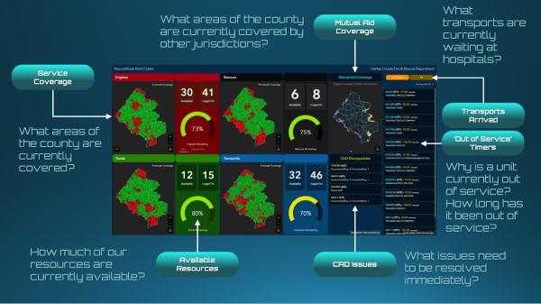
The RescueVision dashboard allows officers to obtain information on:
- Service coverage: How units are distributed throughout the county
- Resource availability: How many of each resource is ready to respond to new incidents
- Units out of service: What is not available for dispatch, how long they have been unavailable and why
- Transport location: How many units (medics and ambulances) are at medical facilities after transporting patients
- Mutual aid coverage: Which areas of the county are being covered by other jurisdictions
- Discrepancies: What actionable discrepancies can be found related to information in other Fire and Rescue systems
FILLING A NEED
Since its launch, the new system has made an important impact on the county's ability to serve residents and keep them safe.
“RescueVision shows how agile software development can come together with real-time data to provide actionable information right when it is needed,” said John Morrison, Data Analytics Strategy Manager. “We strive to be on the cutting edge of GIS technologies, and this is one of our many tools we use to ensure we’re providing the highest quality coverage to our residents and visitors.”
THE POWER OF MAP-BASED TECHNOLOGY
Our county departments continue to use geospatial technology to advance the county’s mission and strategic plan. Learn more about GIS and all the maps, services and data available to help explore your county.