Transportation

CONTACT INFORMATION: Our office is open 8:00 AM-4:30 PM M-F
703-877-5600 TTY 711
4050 Legato Road, Suite 400
Fairfax, VA 22033
Gregg Steverson
Director

Shreve Road Shared Use Path

Public Meeting Information

Providence District Supervisor Dalia Palchik, Dranesville District Supervisor James Bierman and the Fairfax County Department of Transportation (FCDOT) held a Public Information Meeting on Thursday, May 29, 2025, at Shrevewood Elementary School to discuss the Shreve Road Shared Use Path project. FCDOT presented a Conceptual Design of the project and the meeting included time for questions and feedback.

View: Shreve Road/Haycock Road & Route 7 Meeting Presentation
View: Shreve Road Shared Use Path Roll Plots

This meeting was held in conjunction with the Haycock Road and Route 7 Intersection improvements project; the two projects will be designed and constructed concurrently.

The comment period for this project closed on June 13, 2025.

Responses to Citizens' Comments and Questions from the May 29, 2025 Meeting

The proposed project will install a combination of safety measures including roadway design improvements and traffic control devices for the existing sharp horizontal curve on Shreve Road, southwest of project limit, near W&OD trail connection. The measures include installation of:

  • New curb and gutter along the outside of the curve for a better visual and physical delineation of the roadway curve limits. 
  • Tree trimming along the inside of the curve to improve the sight line for southbound traffic.
  • Intelligent Transportation System (ITS) Dynamic Speed Feedback and Curve Warning:
    • The ITS dynamic speed feedback sign will display driver's speed in comparison to the regulatory/curve warning speed as they approach the horizontal curve.
    • Existing chevron signs will be replaced with ITS dynamic curving warning system that includes oversized horizontal curve chevron signs with flashing LED lights embedded in the signs. 
    • The lights on chevron signs will be activated using the dynamic speed feedback sign.
    • The ITS system will increase drivers’ awareness of potential speeding and guide drivers through the upcoming horizontal curve.

Dynamic Speed Feedback Sign Left   Dynamic Speed Feedback Sign Right

Figure 1: Examples of ITS Dynamic Speed Feedback

Curve Warning System Left   Curve Warning System Right


Figure 2: Curve Warning Systems

*The exhibits shown above are for example only. The posted advisory speed on Shreve Road at the curve is 20-MPH and will be used for the design of the ITS system.*  


The proposed 10’ wide shared use path will be extended all the way to the existing W&OD Trail to maintain a constant width of 10’. The project will review appropriate pedestrian/cyclist warning signage in coordination with NOVA Parks. 

As requested by the Community, the County evaluated if a high visibility crosswalk can be installed on Shreve Road at the Hickory Street intersection. However, this location is unsafe to install a crosswalk due to inadequate sight distance for vehicles approaching the crosswalk. The requested location does not meet the minimum requirements for sight distance according to VDOT design standards. 

  • Curb bump-outs: The improvements at northwest side of the intersection include curb bump-outs on Shreve Road and Gordons Road. 
    • The County will further enlarge the bump-out on Gordons Road but will not be able to extend the bump-out. 
    • Any extension of the bump-out from the proposed location as well as widening of the sidewalk from the bump-out to Falls Place will require removal of existing onsite parking on Gordons Road.
  • High visibility (HV) crosswalk on Shreve Road: Although a HV crosswalk is proposed at this intersection, VDOT may only allow a standard crosswalk at this location. According to VDOT design standards, a HV crosswalk is not allowed at stop-controlled intersections.
  • Pavement Striping: The existing parking lane on Shreve Road southbound will be striped up to the proposed bump-out curb which will delineate parking lane from the turn lane to Gordons Road and reduce the unmarked pavement area.
  • Additional Traffic Measure: In September 2025, traffic counts were conducted at the intersection of Gordons and Shreve Road when schools were in session. Based on the data, a traffic signal is not warranted at this intersection. The County is evaluating other measures including a four-way stop/Rectangular Rapid Flashing Beacon (RRFB). 
  • Drainage: This project improvement does not contribute any runoff to the southwest corner of the intersection, and therefore it is outside of the project scope to implement the requested existing drainage condition improvement at the corner.

The proposed improvements at the intersection include lane reconfiguration to install a 6’ wide pedestrian refuge island on Shreve Road as well as curb extension to minimize right turn radius. The County further evaluated for a wider island and will be able to accommodate an 8’ wide refuge island. The median will be designed to align with new lane configuration on Haycock Road on the other side of the intersection.

At the northeast and southeast corners of the Shreve Road and Route 7 intersection, the proposed brick sidewalk sections will be replaced by concrete.

The project will assess existing street lights along the east side of Shreve Road to make sure they meet current standards for visibility and enhance safety. The County will develop a lighting design plan in coordination with utility company to address any deficiency. 

Shreve Road (State Route 703) is maintained by VDOT.  The road is categorized as GS-7, Major Collector Road as per VDOT Functional Classification. According to VDOT Roadway Design Manual, the minimum roadway width for GS-7 roads are 11’ (Appendix A1, page A1-23). Although NACTO Design Guide recommends for a 10’ lane width in Urban areas, it is not adopted by VDOT.  

Shreve Road is maintained by VDOT. The County does not have the authority to change the speed limit of a road maintain by VDOT. According to VDOT, the local VDOT District Traffic Engineer has the authority to increase or decrease speed limits and considers whether a review of a particular speed limit is warranted based on VDOT’s Speed Limit Change Process policy.  

FCDOT received several comments to include improvements for the above-mentioned locations. These locations are outside of the project scope. Project staff will forward these comments to appropriate FCDOT divisions for future consideration.

Project Description

This Shreve Road Shared Use Path Project will construct approximately 1,300' long, 10' wide shared use path along the east side of Shreve Road, from the W&OD trail to the intersection of Leesburg Pike (Route 7). This includes the replacement of a section of existing concrete sidewalk at the north end of the project near the intersection. This portion of the path will remain concrete, and connected to the curb with no buffer. 

Shreve Road Shared Use Path Project Map
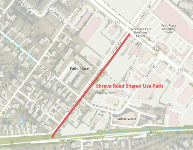
The project also involves reconfiguring the existing travel lanes at the intersection with Leesburg Pike (Route 7). The existing lane configuration will be kept in the northbound direction, while the southbound direction will be reduced from two receiving lanes to one. Additionally, a median refuge island will be installed on the south leg of the intersection. 
 

Questions? Comments?


Northern Virginia Transportation Authority

Fairfax Virtual Assistant