
Transportation Alert:

The surveys for each district regarding active transportation project prioritization closed at 4:30 p.m. on Tuesday, March 31. FCDOT staff are reviewing and evaluating the survey results and all comments submitted. Thank you to all who participated in this effort.
The Fairfax County Board of Supervisors has set a goal to invest $100 million in bicycle and pedestrian infrastructure improvements between 2021 and 2027. In fall 2025, the board approved an additional $25.43 million in one-time funding for projects within each magisterial district. So far, $82.12 million has been committed, with the remaining $17.88 million expected to be allocated within the targeted timeframe.
View Approved Funding and Projects
Working with district supervisors, the Fairfax County Department of Transportation (FCDOT) has created a list of proposed projects for each district. These focus on opportunity areas, high pedestrian and bicycle activity zones, and locations near key destinations like schools, parks and transit stops. These projects were identified through community and stakeholder feedback as well as recommendations from corridor studies and site reviews. The list of proposed projects to receive funding is available for public review and comment.
Public feedback is critical to finalizing the prioritization and informing the selection of approved projects for available funding. The Fairfax County Department of Transportation (FCDOT) hosted two public meetings and collected community input for each district by way of a survey which ended at 4:30 p.m., on March 31, 2026. Recordings and meeting materials are available below. FCDOT staff are reviewing and evaluating the survey results and all comments submitted.
Thank you to all who participated in this effort.
Please review the list of projects proposed for the Braddock District below or view the interactive Active Transportation Project Prioritization Map.
Project Number and Title | Description |
| 4. Burke Lake Road/Signal Hill Drive | Construct a pedestrian refuge in the existing crosswalk on Burke Lake Road at the Signal Hill Drive intersection and add or upgrade curb ramps and pedestrian-scale lighting. |
| 16. Little River Turnpike from Wakefield Chapel Road to Lake Drive | Construct approximately 900 feet of Active Transportation facilities along the south side of Little River Turnpike from Wakefield Chapel Road to Lake Drive. |
| 21. Little River Turnpike/I-495 North Exit Ramp | Improve the existing trail crossing on the south side of Little River Turnpike at the Exit Ramp to I-495 North and the existing trail intersection at Accotink Parkway. |
| 23. Monument Drive from Park Vista Boulevard to Government Center Parkway | Construct approximately 650 feet of Active Transportation facilities along the west side of Monument Drive from Park Vista Boulevard to Government Center Parkway. |
| 28. Maple Avenue/John Robert Way | Construct approximately 20 feet of Active Transportation facilities along the east side of Maple Avenue at the John Robert Way intersection. |
| 32. Sideburn Road from 5225 Sideburn Road to Linfield Street | Construct approximately 500 feet of Active Transportation facilities along the east side of Sideburn Road from 5225 Sideburn Road to Linfield Street. |
| 55. Holly Avenue/Route 29 | Construct approximately 1,000 feet of Active Transportation facilities along the west side of Holly Avenue north of Route 29. |
| 57. Monument Drive from Monument Hill Way to Government Center Parkway | Construct approximately 1,500 feet of Active Transportation facilities along the west side of Monument Drive from Monument Hill Way to Government Center Parkway. |
| 242. Heritage Drive from Little River Turnpike to Heritage Woods Way | Improve approximately 600 feet of Active Transportation facilities on Heritage Drive between Little River Turnpike and Heritage Woods Way. |
| 628. Heming Avenue from Braddock Road to Heming Avenue | Construct approximately 80 feet of Active Transportation facilities on Heming Avenue from Braddock Road south to the existing sidewalks along Heming Avenue. |
| 629. Heritage Drive/Four Year Run | Improve the existing marked crosswalk on Heritage Drive at the Four Year Run intersection near Annandale High School by installing curb extensions and on-street parking restrictions. |
| 631. Little River Turnpike/Guinea Road | Improve Active Transportation facilities at the Little River Turnpike and Guinea Road intersection to possibly include an additional marked crosswalk, new curb ramps, and approximately 50 feet of connection at the northeast corner of the intersection. |
| 632. Random Hills Road/Ridgetop Road/Verret Drive | Relocate the existing marked crosswalk on Random Hills Road at the intersection with Ridgetop Road and Verret Drive to the western approach of the intersection, construct a pedestrian refuge island, and upgrade pedestrian-scale lighting and signage. |
| 669. Route 29 from Legato Road to Piney Ridge Branch Road | Construct approximately 750 feet of Active Transportation facilities on the north side of Route 29 from Legato Road to Piney Ridge Branch Road. |
| 681. Hunter Village Drive from Old Keene Mill Road to Gerry Connolly Cross County Trail | Construct approximately 300 feet of Active Transportation facilities on the east side of Hunter Village Drive from Old Keene Mill Road to the Gerry Connolly Cross County Trail. |
| 721. Guinea Road/Olley Lane/Harford Lane | Improve pedestrian crossings at the Guinea Road intersection with Olley Lane and Harford Lane by upgrading crosswalk to high-visibility markings, potentially adding pedestrian refuges and additional crosswalk, upgrading curb ramps and pedestrian lighting. |
Please review the list of projects proposed for the Dranesville District below or view the interactive Active Transportation Project Prioritization Map.
Project Number and Title | Description |
| 68. Coppermine Road from Centreville Road to Sunrise Valley Drive | Install approximately 4,000 feet of bike lanes on Coppermine Road from Centreville Road to Sunrise Valley Drive. |
| 73. Dolley Madison Boulevard/Old Dominion Drive | Upgrade all the existing crosswalks at the Dolley Madison Boulevard and Old Dominion Drive intersection to high-visibility markings, reconstruct curb ramps, and add or upgrade pedestrian-scale lighting at the intersection. |
| 77. Great Falls Street/Moly Drive | Install new marked crosswalk and pedestrian refuge on Great Falls Street at Moly Drive, reconstruct curb ramps, and add or upgrade pedestrian-scale lighting. |
| 84. Kensington Road from Dolley Madison Boulevard to Melrose Drive | Construct approximately 1,200 feet of Active Transportation facilities along Kensington Road from Dolley Madison Boulevard to Melrose Drive. |
| 105. Park Avenue from Old Dominion Drive to Spring Vale Avenue | Construct approximately 600 feet of Active Transportation facilities along Park Avenue from Old Dominion Drive to Spring Vale Avenue. |
| 111. Birch Road from Kirby Road to Birch Grove Court | Construct approximately 500 feet of Active Transportation facilities on the east side of Birch Road from Kirby Road to Birch Grove Court. |
| 122. Chain Bridge Road/Salona Village Shopping Center | Construct a median pedestrian refuge and curb ramps for the existing crosswalk on Chain Bridge Road at the Salona Village Shopping Center entrance. |
| 704. Churchill Road/McLean Park Trail | Improve the existing crosswalk across Churchill Road connecting to the McLean Central Park Trail between Dead Run Drive and Ingleside Avenue including upgraded signage and pedestrian-scale lighting. |
| 705. Lewinsville Road/Bridle Path Lane/Falstaff Road | Install a marked crosswalk across Lewinsville Road at Bridle Path Lane/Falstaff Road including potential pedestrian refuge, curb extensions, upgraded signage, and pedestrian-scale lighting. |
| 709. Live Oak Drive from Langley Swim and Tennis Club to the Potomac Heritage National Scenic Trail | Conduct a study to evaluate the feasibility of constructing approximately 3,800 feet of Active Transportation facilities along Live Oak Drive from the Langley Swim and Tennis Club to the Potomac Heritage National Scenic Trail. (Updated Feb. 26, 2026) |
| 714. Great Falls Street/Sea Cliff Road | Improve the existing marked crosswalk on Great Falls Street at Sea Cliff Road including potential pedestrian refuge, curb extensions, upgraded signage, and pedestrian-scale lighting. |
| 715. Walker Road/Columbine Street | Improve the existing marked crosswalk on Walker Road that connects the Village Centre shopping plaza north of Columbine Street to the shopping center on the east side of Walker Road by installing upgrade signage and pedestrian refuge. |
| 716. Lewinsville Road from Old Falls Road to Meadow Green Lane | Construct approximately 1,200 feet of Active Transportation facilities along the north side of Lewinsville Road from Old Falls Road to the existing sidewalk east of Meadow Green Lane. |
| 719. Old Dominion Drive/Spring Hill Road | Install marked crosswalks at Old Dominion Drive and Spring Hill Road intersection, construct 130 feet of Active Transportation facilities along the west side of Spring Hill Road and a crosswalk connecting to existing trail at the VFW entrance. |
| 720. Utterback Store Road/Loran Road | Construct approximately 1,100 feet of Active Transportation facilities on the west side of Utterback Store Road from Leesburg Pike to Loran Road including a marked crosswalk, upgraded curb ramps, and pedestrian signage across Utterback Store Road at Loran Road near Forestville Elementary School. (Updated Feb. 26, 2026) |
Please review the list of projects proposed for the Franconia District below or view the interactive Active Transportation Project Prioritization Map.
Project Number and Title | Description |
| 132. South Kings Highway/Memorial Street | Install additional marked crosswalks, reconstructed curb ramps, and upgraded pedestrian-scale lighting at the South Kings Highway and Memorial Street intersection. |
| 152. Buckman Road/Janna Lee Avenue | Construct approximately 400 feet of Active Transportation facilities on the south side of Buckman Road and the west side of Janna Lee Avenue near El Camino Place. Restripe and add crosswalks, curb ramps, and refuge at Buckman Road and Janna Lee Avenue. |
| 157. Lockheed Boulevard/Fordson Road | Install additional marked crosswalks, reconstructed curb ramps, and upgraded pedestrian-scale lighting at the Lockheed Boulevard and Fordson Road intersection. |
| 163. North Kings Highway/Fairhaven Avenue | Install marked crosswalk across North Kings Highway at Fairhaven Avenue including reconstructed curb ramps, upgraded pedestrian lighting, and signage. |
| 639. Fordson Road/Cyrene Boulevard | Construct a median pedestrian refuge island in the cross-hatched area of the existing crosswalk on Fordson Road at Cyrene Boulevard including reconstructed curb ramps, upgraded pedestrian lighting, and signage. |
| 640. Kalmia Street from Elder Avenue to Hackberry Street | Construct approximately 1,100 feet of Active Transportation facilities on Kalmia Street from Elder Avenue to Hackberry Street. |
| 641. Ladson Lane/Evergreen Farm Place | Install a marked crosswalk on Ladson Lane at Evergreen Farm Place and the Costco entrance including potential curb extensions, upgraded curb ramps, pedestrian lighting, and signage. |
| 643. Hackberry Street/Melia Street | Construct approximately 350 feet of trail connecting the intersection of Hackberry Street and Melia Street to the existing WMATA trail to provide pedestrian access to the Franconia Springfield Metro. |
| 681. Hunter Village Drive from Old Keene Mill Road to the Gerry Connolly Cross County Trail | Construct approximately 125 feet of Active Transportation facilities on the east side of Hunter Village Drive from Old Keene Mill Road to the Gerry Connolly Cross County Trail. |
| 685. Backlick Road/Spring Garden | Install new marked crosswalks on the northern and western approaches of the Backlick Road and Spring Garden intersection including upgraded curb ramps, pedestrian lighting, and signage. |
| 707. Franconia Road/Westchester Street | Improve the existing marked crosswalk on Franconia Road at Westchester Street including upgraded pedestrian-lighting and signage. |
| 722. Poag Street/Shaffer Drive | Construct approximately 50 feet of Active Transportation facilities at the end of the Poag Street cul-de-sac at the existing connection to Shaffer Drive. |
| 731. Morning View Lane/Tassia Drive | Improve the existing marked crosswalk on Morning View Lane at the Island Creek Elementary entrance and Tassia Drive including modified curb ramps, upgraded pedestrian lighting, and potentially curb extensions, or refuge island. |
| 732. Franconia Road/Craft Road | Improve the existing marked crosswalk on Franconia Road at the Mark Twain Elementary entrance and Craft Road by upgrading pedestrian lighting and potentially constructing curb extensions or pedestrian refuge island. |
Please review the list of projects proposed for the Hunter Mill District below or view the interactive Active Transportation Project Prioritization Map.
Project Number and Title | Description |
| 68. Coppermine Road from Centreville Road to Sunrise Valley Drive | Install approximately 4,000 feet of bike lanes on Coppermine Road from Centreville Road to Sunrise Valley Drive. |
| 123. Centerville Road/Floris Elementary School | Install new marked crosswalk with pedestrian refuge island, reconstructed curb ramps, and upgraded pedestrian-scale lighting at the entrance to Floris Elementary School on Centreville Road. |
| 193. West Ox Road from Rodgers Lane to Floris Lane | Construct approximately 600 feet of Active Transportation facilities along the south side of West Ox Road between Rodgers Lane and Floris Lane including a new marked crosswalk and pedestrian-scale lighting at Frying Pan Farm Park. |
| 196. Stevenage Road from Bennington Woods Road to Reston Parkway | Construct 700 feet of Active Transportation facilities on the south side of Stevenage Road from Bracknell Drive west to existing sidewalk at shopping center entrance. Install crosswalks on Stevenage Road between Bennington Woods Road and Reston Parkway. |
| 203. Colts Neck Road from Glade Drive to Branleigh Park Court | Construct approximately 600 feet of Active Transportation facilities along the west side of Colts Neck Road from Glade Drive to Branleigh Park Court. |
| 205. Sunrise Valley Drive from Glade Drive to the Fairfax County Parkway | Replace existing substandard facility with approximately 550 feet of Active Transportation facilities along the north side of Sunrise Valley drive between Glade Drive and Fairfax County Parkway. |
| 645. Fairway Drive from Wiehle Avenue to South Shore Road | Construct approximately 500 feet of Active Transportation facilities on the north side of Fairway Drive from Wiehle Avenue to South Shore Road. |
| 647. Reston Parkway from Bowman Green Drive to Spectrum Center | Construct approximately 550 feet of Active Transportation facilities on the east side of Reston Parkway from the existing trail north of Bowman Green Drive to Spectrum Center. Add new marked crosswalk and curb ramps on Reston Parkway at Spectrum Center. |
| 648. Reston Parkway/Hopper Street | Construct signalized pedestrian marked crosswalk with median refuge across Reston Parkway at the Hopper Street intersection. |
| 649. Ridge heights Road from South Lakes Drive to Lakewinds Drive | Construct approximately 600 feet of Active Transportation facilities on the south side of Ridge Heights Road from South Lakes Drive to the sidewalk across from Lakewinds Drive. Add crosswalk with new curb ramps and pedestrian lighting at Lakewinds Drive. |
| 650. Sunrise Valley Drive/Lakeport Way | Install new marked crosswalk with pedestrian refuge island, reconstructed curb ramps, upgraded signage and pedestrian-scale lighting across Sunrise Valley Drive at Lakeport Way. |
| 651. Sunrise Valley Drive from Soapstone Drive to Indian Ridge Road | Construct approximately 850 feet of Active Transportation facilities on the south side of Sunrise Valley Drive from Soapstone Drive to Indian Ridge Road. |
| 654. Westwood Center Drive/Sheraton Tysons Drive | Construct a marked crosswalk with pedestrian signals and curb ramps crossing Westwood Center Drive at Sheraton Tysons Drive. |
| 655. Wiehle Avenue/Reston Station Boulevard | Install a signalized crosswalk on the southern approach of the Wiehle Avenue and Reston Station Boulevard intersection. |
| 729. Fairway Drive/Apricot Court | Install a mid-block marked crosswalk with curb ramps on Fairway Drive near Apricot Court to provide pedestrian access to the Hook Road Recreational Area park. |
Please review the list of projects proposed for the Mason District below or view the interactive Active Transportation Project Prioritization Map.
Project Number and Title | Description |
| 230. Columbia Pike at Mason District Park | Improve Active Transportation facilities at the Mason District Park entrance and trail on the south side of Columbia Pike including possible additional crosswalk and trail connection, median cut-throughs, upgraded curb ramps and pedestrian-scale lighting. |
| 231. Columbia Pike/Sleepy Hollow Road | Extend the existing trail on the south side of Columbia Pike approximately 350 feet east to Sleepy Hollow Road. Install signalized crosswalk on Columbia Pike at Sleepy Hollow Road with reconstructed curb ramps and pedestrian-scale lighting. |
| 254. Arlington Boulevard/ Graham Road | Improve Active Transportation facilities at Arlington Boulevard and Graham Road including potential additional marked crosswalk, median cut-throughs and pedestrian refuge, reconstructed curb ramps, and upgraded pedestrian-scale lighting. |
| 263. Little River Turnpike from Lake Drive to 8428 Little River Turnpike | Construct approximately 600 feet of Active Transportation facilities along the north side of Little River Turnpike from the Lake Drive intersection to the existing sidewalk at 8428 Little River Turnpike. |
| 270. Seminary Road/Carlin Springs Road | Construct approximately 200 feet of Active Transportation facilities along the north side of Seminary Road just west of the Carlin Springs Road intersection, upgrade curb ramps, and install pedestrian-scale lighting. |
| 271. Carlin Springs Road/Seminary Road | Construct approximately 200 feet of Active Transportation facilities along the west side of Carlin Springs Road just north of the Seminary Road intersection, upgrade curb ramps, and install pedestrian-scale lighting. |
| 280. Little River Turnpike from Roberts Avenue to High Place | Construct approximately 600 feet of Active Transportation facilities along the north side of Little River Turnpike from the service road east of Roberts Avenue to the service road east of High Place including new curb ramps and pedestrian-scale lighting. |
| 302. Leesburg Pike from Rock Spring Avenue to Crossroads Center Way | Upgrade the existing Active Transportation facilities along the north side of Leesburg Pike between Rock Spring Avenue and Crossroads Center Way including reconstructed curb ramps and pedestrian-scale lighting. |
| 320. Columbia Pike/Eastbound Leesburg Pike and Seminary Road ramp | Construct new signalized crosswalk across Columbia Pike at the eastbound Leesburg Pike and Seminary Road ramp including reconstructed curb ramps and pedestrian-scale lighting. |
| 323. Leesburg Pike/Aldi Shopping Center | Construct approximately 10 feet of Active Transportation facilities including installing a new curb ramp to provide pedestrian access from the existing sidewalk on the north side of Leesburg Pike to the Aldi shopping center. |
| 452. Arlington Boulevard/Thomas Jefferson Library | Install Pedestrian Hybrid Beacon at the existing marked crosswalk across Arlington Boulevard near the entrance to Thomas Jefferson Library. Relocate eastbound and westbound bus stops and construct new Active Transportation connections and boarding pads. |
| 453. Route 50/Allen Street | Install additional crosswalks, upgrade parallel style crosswalk to high-visibility markings, relocate existing crosswalk, construct pedestrian refuge(s), reconstruct curb ramps, and install pedestrian- scale lighting at Route 50 and Allen Street. |
| 631. Little River Turnpike/Guinea Road | Improve Active Transportation facilities at the Little River Turnpike and Guinea Road intersection to possibly include an additional marked crosswalk, new curb ramps, and approximately 50 feet of connection at the northeast corner of the intersection. |
| 657. Little River Turnpike/Woodland Road | Construct bus pad and Active Transportation facilities connecting to the bus stop on the south side of Little River Turnpike east of Woodland Road. Install a marked crosswalk and curb ramps at the bus stop in front of Little River Shopping Center. |
| 688. Gallows Road from Holes Run Drive to I-495 North ramp | Construct approximately 200 feet of Active Transportation facilities on the north side of Gallows Road from the existing sidewalk west of Holmes Run Drive to the I-495 North ramp including a new crosswalk on Gallows Road at Holmes Run Drive. |
| 711. Woodburn Road/Spicewood Drive and Robey Avenue | Install Rectangular Rapid Flashing Beacons at the crosswalk on Woodburn Road at the Gerry Connolly Cross County Trail crossing between Spicewood Drive and Robey Avenue. |
Please review the list of projects proposed for the Mount Vernon District below or view the interactive Active Transportation Project Prioritization Map.
Project Number and Title | Description |
| 163. North Kings Highway/Fairhaven Avenue | Install high-visibility marked crosswalk across North Kings Highway at Fairhaven Avenue. Reconstruct existing curb ramps and upgrade pedestrian-scale lighting. |
| 166. Sherwood Hall Lane/Parkers Lane | Install pedestrian signals at Sherwood Hall Lane and Parkers Lane. Add curb ramps on the eastern approach crosswalk. Upgrade southern approach crosswalk markings to high-visibility. Upgrade pedestrian facilities for both separated right-turn lane islands. |
| 337. Lorton Station Boulevard at the Stonegarden Drive/Grace Church Lane and Lee Masey Drive/Old Beech Court intersections | Improve two existing crosswalks on Lorton Station Boulevard at the Stonegarden Drive/Grace Church Lane and Lee Masey Drive/Old Beech Court intersections by constructing pedestrian refuges and upgrading curb ramps, signage, and pedestrian lighting. |
| 345. Fairview Drive from Eastern Grid Street to the existing sidewalk east of Phillips Drive | Construct approximately 1,000 feet of Active Transportation facilities along the north side of Fairview Drive from Eastern Grid Street to the existing sidewalk east of Phillips Drive. |
| 348. Radford Avenue from Jackson Place to the existing sidewalk south of Sonia Court | Construct approximately 900 feet of Active Transportation facilities along the east side of Radford Avenue from Jackson Place to the existing sidewalk south of Sonia Court. |
| 352. Richmond Highway from Armistead Road south to the existing sidewalk past the gas station entrance | Construct approximately 350 feet of Active Transportation facilities along the west side of Richmond Highway from Armistead Road south to the existing sidewalk past the gas station entrance. |
| 357. Dart Drive from Richmond Highway BRT project limits to the existing sidewalk east of Mums Drive | Construct approximately 1,000 feet of Active Transportation facilities along the south side of Dart Drive from Richmond Highway BRT project limits to the existing sidewalk east of Mums Drive. |
| 364. Rixey Drive/Byrd Lane | Install a new marked crosswalk across Rixey Drive at Byrd Lane with new curb ramps, pedestrian-scale lighting, and signage. |
| 370. Sherwood Hall Lane from existing on-road bike lanes east of the Gum Springs Center entrance to tie into Richmond Highway BRT active transportation facilities | Improve bicycle facilities on Sherwood Hall Lane from existing on-road bike lanes east of the Gum Springs Center entrance to tie into Richmond Highway BRT active transportation facilities. |
| 619. From Cameron Run Terrace under Richmond Highway and connecting to the Mount Vernon Trail on the I-95 North ramp | Conduct a feasibility study to construct approximately 1,400 feet of Active Transportation facilities from Cameron Run Terrace under Richmond Highway and connecting to the Mount Vernon Trail on the I-95 North ramp. |
| 661. Lorton Road/Lorton Market Street | Improve pedestrian crossings at the Lorton Road and Lorton Market Street intersection by adding a high-visibility crosswalk on the western approach, constructing new curb ramps, and installing pedestrian-scale lighting. |
| 662. Lorton Road/Lorton Station Boulevard/Armistead Road | Improve existing crosswalks at the Lorton Road intersection with Lorton Station Boulevard and Armistead Road by upgrading curb ramps and pedestrian lighting. |
| 663. Pohick River Drive from Armistead Road to the end of the cul-de-sac | Construct approximately 1,300 feet of Active Transportation facilities along Pohick River Drive from Armistead Road to the end of the cul-de-sac. |
| 664. Richmond Highway/Dutchman Drive | Improve pedestrian crossings on Richmond Highway at Dutchman Drive and Lorton Community Center and Library by upgrading existing crosswalks to high-visibility markings, new curb ramps, and installing pedestrian lighting. |
Please review the list of projects proposed for the Providence District below or view the interactive Active Transportation Project Prioritization Map.
Project Number and Title | Description |
| 120. Magarity Road from Lunceford Lane to Ware Road | Construct approximately 850 feet of Active Transportation facilities along the south side of Magarity Road from Lunceford Lane to Ware Road. |
| 254. Arlington Boulevard/Graham Road | Improve Active Transportation facilities at Arlington Boulevard and Graham Road including potential additional marked crosswalk, reconstructed curb ramps, and upgraded pedestrian-scale lighting. |
| 413. Eskridge Road/Strawberry Lane | Improve the existing marked crosswalk on Eskridge Road at Strawberry Lane by upgrading the pedestrian lighting and signage and potentially constructing a median pedestrian refuge. |
| 414. Vaden Drive/Royal Victoria Drive | Upgrade the Active Transportation crossings at the Vaden Drive and Royal Victoria Drive intersection to improve access to the Providence Community Center including adding and upgrading pedestrian signage, lighting, and curb ramps. |
| 448. Route 29 from Dover Lane to Meadow View Road | Construct approximately 450 feet of Active Transportation facilities along the south side of Route 29 from Dover Lane to Meadow View Road. |
| 452. Arlington Boulevard/Thomas Jefferson Library Entrance | Install pedestrian hybrid beacon at existing crosswalk on Arlington Boulevard near the entrance to Thomas Jefferson Library. May include relocating eastbound and westbound bus stops and constructing new Active Transportation connections and boarding pads. |
| 453. Route 50/Allen Street | Relocate eastern approach crosswalk at Route 50 and Allen Street, upgrade existing parallel crosswalks to high-visibility markings, install additional crosswalks and pedestrian refuges, reconstruct curb ramps, and install pedestrian-scale lighting. |
| 478. Route 29 from Prosperity Avenue east to the existing Metrobus bus shelter | Construct approximately 300 feet of Active Transportation facilities along the south side of Route 29 from Prosperity Avenue east to the existing Metrobus bus shelter. |
| 479. Hilltop Road/Old Lee Highway | Improve Active Transportation facilities at the intersection of Hilltop Road and Old Lee Highway. |
| 484. Hollywood Road from Route 29 to the service road entrance | Construct approximately 100 feet of Active Transportation facilities along the west side of Hollywood Road from Route 29 to the service road entrance, including new intersection curb ramp(s). |
| 485. Route 29 from Hollywood Road to Mary Street | Construct approximately 1,000 feet of Active Transportation facilities along the north side of Route 29 from Hollywood Road to Mary Street. |
| 486. Emma Lee Street from Route 29 north to the existing sidewalk | Construct approximately 75 feet of Active Transportation facilities and improved curb ramps on the west side of Emma Lee Street from Route 29 north to the existing sidewalk. |
| 491. Blake Lane from Sutton Road south across the Blake Lane Bridge over I-66 | Improve Active Transportation facilities on Blake Lane from the Sutton Road intersection south across the Blake Lane bridge over I-66. |
| 492. Route 29/Eskridge Road/Merrilee Drive | Improve existing crosswalks at the Route 29 intersection with Eskridge Road and Merrilee Drive including upgraded curb ramps and pedestrian lighting as well as potential curb extensions. |
| 494. Route 29/West Street | Install new crosswalk on the western approach of Route 29 and West Street intersection including reconstructed curb ramps, pedestrian lighting, and Active Transportation connections to nearby bus stops. Install marked crosswalks on the service road. |
Please review the list of projects proposed for the Springfield District below or view the interactive Active Transportation Project Prioritization Map.
Project Number and Title | Description |
| 536. Route 50/Stringfellow Road | Improve the existing crosswalks at the Route 50 and Stringfellow Road intersection including adding median pedestrian refuge. |
| 540. Rolling Road from Edinburgh Drive to Tanner Robert Court | Construct approximately 450 feet of Active Transportation facilities on the west side of Rolling Road from the southern Edinburgh Drive intersection to Tanner Robert Court. |
| 542. Westbrook Drive from Stringfellow Road to Whisper Willow Drive and Collin Chase Place intersection | Construct approximately 1,000 feet of Active Transportation facilities on Westbrook Drive from Stringfellow Road to the Whisper Willow Drive and Collin Chase Place intersection. |
| 546. Route 29 from Piney Branch Road to West Ox Road | Construct approximately 1,300 feet of Active Transportation facilities on the north side of Route 29 from Piney Branch Road to West Ox Road. |
| 548. Old Keene Mill Road from Hillside Road to Bauer Drive and Greeley Boulevard Intersection | Construct approximately 1,000 feet of Active Transportation facilities on the north side of Old Keene Mill Road from Hillside Road to the Bauer Drive and Greeley Boulevard intersection. |
| 552. Monument Drive/Fair Ridge Drive | Improve the existing crosswalks at the Monument Drive and Fair Ridge Drive intersection including constructing additional pedestrian refuge, reconstructing curb ramps, and installing or upgrading pedestrian-scale lighting. |
| 565. Burke Road/Old Burke Lake Road | Improve Active Transportation facilities at the intersection of Burke Road and Old Burke Lake Road by installing marked crosswalks, new curb ramps, pedestrian refuges, and pedestrian-scale lighting. |
| 568. Old Keene Mill Road from Field Baster Drive to Huntsman Boulevard | Construct approximately 1,400 feet of Active Transportation facilities on the south side of Old Keene Mill Road from the existing sidewalk east of Field Master Drive to Huntsman Boulevard. |
| 569. Monument Drive/West Ox Road | Improve Active Transportation facilities at the Monument Drive and West Ox Road intersection including reconstructed curb cuts, curb ramps, pedestrian median refuges, and pedestrian island refuges. |
| 630. Legato Road/Dixie Hill Road/Ruffin Drive | Upgrade the existing marked crosswalk at Legato Road and Dixie Hill Road and Ruffin Drive by installing Rectangular Rapid Flashing Beacons, new curb ramps, pedestrian lighting, advanced warning signage, and possible pedestrian refuge. |
| 668. Stringfellow Road/Chantilly Regional Library and Chantilly High School | Install a marked crosswalk, curb ramps, and pedestrian-scale lighting on Stringfellow Road to provide a pedestrian crossing from the entrance of the Chantilly Regional Library to the entrance of Chantilly High School. |
| 669. Route 29 from Legato Road to Piney Ridge Branch Road | Construct approximately 750 feet of Active Transportation facilities on the north side of Route 29 from Legato Road to Piney Ridge Branch Road. |
| 671. Monument Drive/Monument Court | Install a marked crosswalk, median pedestrian refuge, curb ramps, and pedestrian-scale lighting on Monument Drive at the Monument Court intersection. |
| 672. Hillside Road/Hall Street and Timber Hollow Lane | Install a marked crosswalk, possible pedestrian refuge or curb extensions, reconstructed curb ramps, and pedestrian-scale lighting on Hillside Road at the Hall Street and Timber Hollow Lane intersection. |
| 697. Old Kene Mill Road/Rolling Valley Park and Ride | Construct approximately 40 feet of Active Transportation facilities on the north side of Old Keene Mill Road at the Rolling Valley Park and Ride entrance with a new marked crosswalk and curb ramps. |
Please review the list of projects proposed for the Sully District below or view the interactive Active Transportation Project Prioritization Map.
Project Number and Title | Description |
| 573. Route 29/Trinity Parkway/Centrewood Drive | Install pedestrian safety improvements at the Route 29 intersection with Trinity Parkway and Centrewood Drive. |
| 574. Pickwick Road from Leland Road to Johnson Avenue | Construct approximately 800 feet of Active Transportation facilities along the west side of Pickwick Road from Leland Road to Johnson Avenue. |
| 579. Route 50/Centerview Drive/Sullyfield Circle | Upgrade crosswalk on eastern approach of Route 50 intersection with Centerview Drive and Sullyfield Circle to high-visibility markings, reconstruct curb ramps, improve pedestrian lighting, and evaluate additional crosswalk and pedestrian refuge islands. |
| 580. Route 50 from Lees Corner Road to the existing trail crosswalk west of Galesbury Lane | Construct approximately 1,300 feet of Active Transportation facilities on the north side of Route 50 from Lees Corner Road to the existing bus shelter and trail at the crosswalk that connects to the shopping center entrance west of Galesbury Lane. |
| 582. Route 50/Metrotech Drive/Elmwood Street | Improve Active Transportation facilities at the Route 50 intersection with Metrotech Drive and Elmwood Street including improved pedestrian-scale lighting and potential additional pedestrian refuge islands and crosswalk. |
| 589. Stonecroft Boulevard from Westfields Boulevard to the existing trail crosswalk at Westone Plaza | Construct approximately 500 feet of Active Transportation facilities on the south side of Stonecroft Boulevard from Westfields Boulevard to the existing trail crosswalk at Westone Plaza. |
| 590. Westvields Boulevard from Stonecroft Boulevard to Smithwood Drive and Sequioa Farms Drive | Construct approximately 1,400 feet of Active Transportation facilities on the west side of Westfields Boulevard from Stonecroft Boulevard to Smithwood Drive and Sequoia Farms Drive. |
| 593. EDS Drive from McLearen Road to the existing sidewalk west of the Air and Space Museum Parkway | Construct approximately 1,200 feet of Active Transportation facilities along the north/west side of EDS Drive from Mclearen Road to the existing sidewalk west of the Air and Space Museum Parkway intersection. |
| 595. Metrotech Drive from Route 50 to the Sully Place shopping center | Construct approximately 300 feet of Active Transportation facilities on the east side of Metrotech Drive from Route 50 to the Sully Place shopping center entrance. |
| 605. Fair Ridge Drive from Route 50 north to the existing trail at the rear entrance to the Fair Oaks Fire Station | Construct approximately 750 feet of Active Transportation facilities on the west side of Fair Ridge Drive from Route 50 north to the existing trail at the rear entrance to the Fair Oaks Fire Station. |
| 676. Centrewood Drive/Saint Germain Drive | Improve pedestrian crossings at the Centrewood Drive and Saint Germain Drive intersection by upgrading existing crosswalks to high-visibility markings, reconstructing curb ramps, and adding lighting. |
| 678. Route 29/Trinity Parkway/Machen Road | Improve pedestrian crossings at the Route 29 intersection with Trinity Parkway and Machen Road by installing high-visibility crosswalk markings, upgraded curb ramps, and lighting, and a marked crosswalk on the western approach. |
| 679. Stonecroft Boulevard/Old Lee Road | Improve pedestrian access to Westfield High School by installing marked crosswalks on the southern and western approaches of the Stonecroft Boulevard and Old Lee Road intersection and upgrading pedestrian-scale lighting at all four curb ramps. |
| 702. Stringfellow Road from Fairfax County Parkway to the trail north of Custom House Court | Construct 750 feet of Active Transportation facilities on the west side of Stringfellow Road from Fairfax County Parkway to the trail north of Custom House Court. Install crosswalks and curb ramps at Coralberry Drive and Custom House Court intersections. |
FCDOT regularly receives requests for unfunded active transportation (e.g. biking, walking and rolling) infrastructure improvements from county residents and communities. These requests are combined with unfunded project recommendations from various traffic studies on an unfunded active transportation project list. The following process is used to prioritize these potential projects to inform decisions as funding is identified.
Projects deemed unsuitable based on funding limitations or other factors are removed. Because suitability depends on many factors, projects that are suitable for one funding opportunity may not be suitable for others.
This step is also designed to refine the large list of potential projects into a more manageable selection of the highest priority items. County staff apply two key methodologies to initially score projects' priority level : the Need Analysis Tool and Demand Analysis Tool.
The Need Analysis Tool identifies areas with the highest need for access to safe active transportation facilities as well as those that are culturally less likely to request such improvements. Key factors include: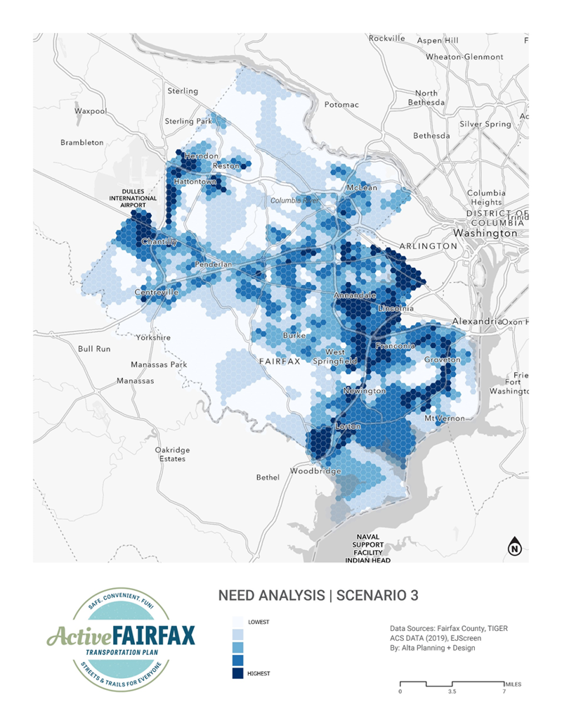
The Demand Analysis Tool identifies locations with the highest density of pedestrian destinations to highlight areas with the greatest existing demand for active transportation facilities. Key factors include: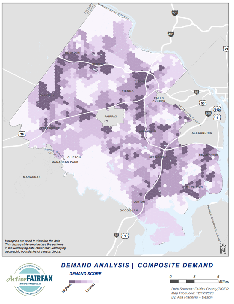
While the Need and Demand Analysis Tools applied in Step 1 are important tools, County staff recognize that there could be important potential projects that fall outside those scoring criterion.
This step integrates coordination with the Board of Supervisors and other stakeholders to capture high priority items that may not have been identified previously.
Projects selected in previous steps for further evaluation are analyzed in further detail. This step is designed to identify the projects that are likely to have the most substantial positive impacts on safety and access. Locations that are expected to be improved by other agencies are filtered out at this stage, as well as projects with major feasibility concerns.
The remaining projects are then scored across three criteria:
Feedback from community members and further analysis (constructability, property and environmental impacts, cost, etc.) help produce the final list of potential projects. This list is then provided to the Board of Supervisors for approval as funding becomes available.
To request a bicycle or pedestrian improvement – such as a sidewalk, crosswalk, ADA pedestrian ramp, etc. – please contact our FCDOT team by using the link below. Be sure to include: