

Land Development Services Alert:
The General VPDES* Permit for Discharges of Stormwater from Construction Activities, also known as the Construction General Permit (CGP), will expire June 30, 2024. Per the permit regulations, any operator who was authorized to discharge under the expiring general permit and who intends to continue coverage (i.e., continue land-disturbing activities after June 30, 2024) must submit a new registration statement at least 60-days before the expiration date. Registration statements are submitted via email.
A complete and accurate registration statement should be submitted to Land Development Services no later than May 1, 2024. If final stabilization has been achieved, please submit a Notice of Termination.
For all VPDES-related applications, including the new 2024 Registration Statement, Notice of Termination, and Transfer Agreement, visit our Forms and Publications Library.
For a list of active 2019 Construction General Permits, visit DEQ’s Stormwater-Construction page.
For questions or additional information, contact the Site Services branch at 703-222-0801, TTY 711.
*VPDES is an acronym for the Virginia Pollutant Discharge Elimination System.
![]() County staff continue to implement additional improvements to the Planning and Land Use System (PLUS) to serve you better. Check out these new PLUS fixes for Land Development Services (LDS) customers.
County staff continue to implement additional improvements to the Planning and Land Use System (PLUS) to serve you better. Check out these new PLUS fixes for Land Development Services (LDS) customers.
PLUS Enhancement |
LDS Customer Benefit |
Updates to Building |
|
|
Added help text to residential and commercial building record applications. |
Added help text to building record applications to better direct customers on what is required when completing the “estimated cost of construction” and “estimated cost of materials” fields as part of the permit application process. |
|
Updated the Building Records Issued Report. |
Added the 2024 reporting year to the existing Building Records Issued report dropdown criteria, allowing customers to view permits issued during the 2024 calendar year. |
|
Updated the Critical Structures record. |
Updated the logic for critical structures records to allow for submission while an amendment or revision is being processed under the parent building permit. |
|
Launched the Elevator Revision record.
|
Allows elevator customers to amend, revise and extend their existing elevator record. |
Update to Site |
|
|
Updated how conditional fees are assessed and invoiced for minor plan records. |
Fees associated with minor plan records approval conditions such as pro rata share, stormwater permits and conservation escrow deposits will be calculated and assessed during application submittal but not invoiced until technical plan approval (i.e., log out). The fee amounts will still be published under the Conditions tab in PLUS. This allows customers to pay resubmission fees on subsequent submissions, without being required to pay their associated approval condition fees when their plan is not yet approved. Minor plan records include conservation plans (CON), infill lot grading plans (INF), rough grading plans (RGP) and minor site plans (MSP). |
|
Parcel validation required at application submittal. |
Customers will be required to enter valid parcel numbers to submit site record applications. Help text is included as is a search option to help find the valid parcel number. This will ensure accurate project information and eliminate errors related to invalid parcels. |
|
Created deck stamp for plats related to bonded grading plans. |
In accordance with Technical Bulletin 24-01 , staff will review standalone deck applications for residential projects associated with an active (i.e., bonded) grading plan and approve with a specialized stamp noting the associated approval conditions. |
|
Created adjoining property notice approval condition, when applicable. |
Updates have been made to the appropriate record workflows to ensure Adjoining Property Notice requirements are noted in PLUS. A Pre-Approval Condition has been added to provide clarity for customers. |
|
Updated the Site Records Approved Report. |
Added the 2024 reporting year to the existing Site Records Approved report dropdown criteria, allowing customers to view approved site-related plans under the 2024 calendar year. |
![]() We welcome your feedback on future PLUS enhancements. If you have ideas to improve the system, please take a moment to enter them here: LDS Customer PLUS Feedback Form.
We welcome your feedback on future PLUS enhancements. If you have ideas to improve the system, please take a moment to enter them here: LDS Customer PLUS Feedback Form.
Fairfax County Zoning Ordinance Article 6 Off-Street Parking and Loading Requirements
The county has just released an electronic calculator to assist in determining required parking for land uses in Fairfax County. This calculator incorporates changes to Section 6100 of the Zoning Ordinance. Using the calculator, you can determine the expected minimum parking for:
The calculator can be used to determine parking requirements associated with changes in site uses and incorporates the ordinance changes from Parking Reimagined designed to create more flexibility for shopping centers, office buildings, and industrial uses.
The Electronic Parking Calculator can be accessed through Section 6100.4 of the ordinance as well as other key areas within Article 6. In addition, the calculator and training resources associated with the updated regulations are available through the LDS Off-Street Parking webpage.
If you have any questions, please contact Michael Davis, Parking Program Manager, in the Site Development and Inspection Division at 703-324-3065, TTY 711.
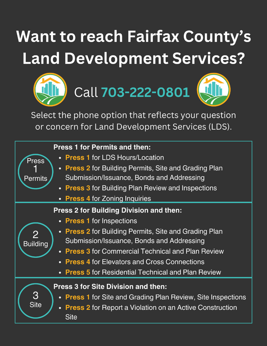
Land Development Services (LDS) recently introduced a new phone tree system. This new phone tree system enhances the customer service experience for anyone calling LDS for assistance. Phone tree options changed from our previous phone tree system to enhance efficiency. See the below graphic for a list of the current calling options. If you are unsure which option is right for you, press 1 and then press 2 and the staff of the customer experience team will help guide you to the appropriate staff member.
![]() County staff continue to implement additional improvements to the Planning and Land Use System (PLUS) to serve you better. Check out these new PLUS fixes for Land Development Services (LDS) customers.
County staff continue to implement additional improvements to the Planning and Land Use System (PLUS) to serve you better. Check out these new PLUS fixes for Land Development Services (LDS) customers.
|
PLUS Enhancement |
LDS Customer Benefit |
Updates to Building |
|
|
Updated the Plan Room to remove a misleading document type. |
Updated the plan room to remove the “plan cover sheet” document type to prevent confusion when naming required files appropriately. The required document is now identified as the Fairfax Cover Sheet. |
|
Added the 2021 Virginia code references. |
Updated PLUS to include the newly adopted 2021 Virginia Construction Code. |
|
Updated the building home screen in Accela Citizen Access (ACA). |
Updated the historical records link and associated description to provide more detail for customers looking to find historical information for a particular address or project. |
|
Update to non-Plan Room records. |
In ACA, customers were able to upload documents to finalized records. This update prevents uploading of documents on records that have a final inspection and are no longer considered active. |
Updates to Site |
|
|
Update ACA application intake to allow customers to submit without payment. |
All site records now allow applicants to upload plans and submit the application before payment is made. Fees will be invoiced by staff at intake and payment will still be required before plan distribution. This helps ensure the proper record type is selected and appropriate submission fees are charged accordingly. It also allows the applicant to seamlessly coordinate online PLUS payment with other parties, when needed. |
|
Create new status and generate email on minor plans ready for logout. |
Staff are now able set the record status to Pending Customer when minor site-related plans (minor site plans, infill lot grading plans, conservation plans and residential rough grading plans) have achieved technical approval, but additional conditions are outstanding such as the conservation agreement, pro rata share agreement and VDOT permit. Once updated, the system will generate an automated email to the applicant letting them know additional action is required and list any outstanding conditions and/or fees. |
|
Designated Plans Examiner (DPE) outside agency review defect corrected. |
DPE outside agency reviews that have been approved in prior submissions will no longer activate, creating a cleaner workflow for staff to navigate. |
|
Update parking reduction/adjustment record. |
Updated the parking reduction/adjustment application in PLUS to align with changes to the Zoning Ordinance that took effect on January 1, 2024. |
![]() We welcome your feedback on future PLUS enhancements. If you have ideas to improve the system, please take a moment to enter them here: LDS Customer PLUS Feedback Form.
We welcome your feedback on future PLUS enhancements. If you have ideas to improve the system, please take a moment to enter them here: LDS Customer PLUS Feedback Form.
The 2024 Unit Price Schedule (UPS) will go into effect on March 1, 2024. This formulaic change reflects a 2.6% increase linked to inflation as published in the Engineering News-Record 2024 Construction Cost Index (published in January 2024). Affected submittals include the following:
In the case of development agreement extension and replacement requests, if the estimated value using the 2024 UPS exceeds the existing posted amount, the county will require supplemental security before approval of the request. As noted above, all bond reductions must be calculated using the 2024 UPS.
The 2024 UPS will be available at the Forms & Publications Library on March 1, 2024.
If you have any questions, please contact Morgan Wolfe in the Bonds and Agreements Center at 703-324-1519, TTY 711.
![]()
Land Development Services (LDS) recently launched new webpages designed to help customers navigate the Planning and Land Use System (PLUS) Digital Plan Room. There are three instructional pages:
The “Uploading Plans and Documents” page helps customers understand how to upload required plans and documents to supplement their PLUS record application.
The “VOID Sheet Process” page explains that applicants cannot remove or delete submitted plan sheets in PLUS, but they can upload a VOID sheet to communicate to a plan reviewer that a specific sheet is no longer applicable to the submitted application package.
The “Corrections Required” page explains what to do when reviewers provide comments on your plans to identify issues that need to be corrected and how to address those issues.
All instructional pages are fully printable if that is preferrable to the web user. These new pages enable customers to navigate the Digital Plan Room with greater confidence. Check these pages out the next time you submit an application in PLUS!
Unsure where to get started with your project? The “Do I Need a Permit” webpage helps you determine whether your project requires a permit. The “Permit Library” webpage provides various site and building permit guides to help you navigate through the application process for every LDS record type available in PLUS.
![]()
Land Development Services (LDS) is pleased to host virtual information sessions on proposed amendments to the county’s Chesapeake Bay Preservation Ordinance (CBPO) and the Public Facilities Manual (PFM). The sessions will be hosted on Microsoft Teams and accessible by either downloading Microsoft Teams, or joining on the web at the time of the meeting. Advanced registration is not required.
Proposed CBPO Amendment on Preservation of Mature Trees and Coastal Resilience and Adaptation to Sea Level Rise
Learn more about a proposed amendment to update the CBPO to incorporate new state-mandated regulatory requirements for proposed requests to build in the Resource Protection Area to preserve mature trees and adapt to rising sea level and storm surge based on climate change. Please note that the two sessions will feature the same presentation.
Proposed PFM Amendment on Street Light Waiver Criteria

Learn more about a proposed PFM amendment to modify the existing street light waiver provision by adding criteria that must be considered before a waiver can be approved by the Director of LDS. Please note that the two sessions will feature the same presentation.
Additional information and meeting links
For more information or reasonable accommodation, contact Jerry Stonefield, Site Code Research and Development Branch, Land Development Services, at 703-324-1791, TTY 711 or email Jerry Stonefield.
![]()
The public may now sign up for notifications about parking adjustment requests submitted to Land Development Services. The Board of Supervisors (Board) approved the repeal and replacement of parking requirements which took effect on Jan. 1, 2024. The Board also requested notifications to allow members of the public to receive alerts regarding parking adjustment requests.
This notification system enhances transparency of our processes and provides citizens access to records to allow an opportunity to comment or seek additional information on proposed parking adjustments. The parking adjustments notification list was made available to the public in Jan. 2024, and it is updated monthly. If you are interested in being notified about parking adjustment submittals, you can sign up for the notification list here. Thank you very much for your interest in this topic area.
The Department of Land Development Services’ introduced an online comprehensive permit library of over 60+ help guides for all record types available in the Planning and Land Use system (PLUS). Within the permit library, customers will find a page devoted to each record type providing guidance through the building and site application and approval process.