Click for larger view
House location plats show the location of structures on an individual property. Submit a house location plat for projects disturbing less than 2,500 square feet of land.
House Location Plat Requirements
Be clear and legible.
Show the entire parcel, and show all property line bearings and distances.
Be drawn to a designated scale no larger than 1” equals 50’.
Show existing and proposed structures properly identified, accurately located and dimensioned and drawn to the designated scale.
Be signed and sealed by a licensed professional in accordance with Virginia Administrative Code 18VAC10-20-380.
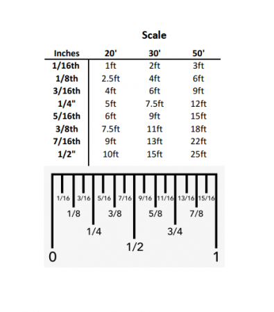
To scale your plat at home, use this conversion chart and a standard 12-inch ruler. Every plat will have the scale provided by the surveyor so check the plat first then use this chart.
Example: On this 1” = 30’ scale plat, the right lot line reads as 119.65’ long. By using the chart and a ruler, it will come out to 3-15/16th” on the ruler.
What does "to scale" mean?
A scaled item retains the original scale indicated by the surveyor of the plat. Here are some things to consider to ensure your plat scales correctly:
The best place to start is with the plat document itself, not a picture of it, photocopy or a version that has potentially been skewed.
Next, the proposed work must be drawn onto the plat to the scale indicated, by either using an engineer’s scale, ruler or digital software. The document itself must be to scale as well as the structure being proposed.
The document is scanned in (made digital) to the original size document. Example: the size paper of your plat is 8 ½" x 14" so you need to scan it to 8 ½" x 14" and not 8 ½" x 11" or another size. By scanning the document correctly, you will not lose the scale.
Surveys that have been photographed, scanned on a phone app, faxed, reduced, enlarged, or otherwise altered may not be accepted if they are not typically to scale and have poor resolution and lack of detail.
COMMON PROJECTS THAT USE A HOUSE LOCATION PLAT
Decks
Screened porches
Additions (including 2nd story over existing structure)
Pools
Garages and carports
Porches and stoops
Retaining walls
Areaways
Sunrooms
Bay windows
Sheds
Detached structures
Demolition of pools and structures
Remember!
Include disturbed area limits (see Calculating Disturbed Area graphic).
Elevation/height of structure is required to be listed within the construction documents.
If there is flood plain present on your property, it must be shown on the plat.
Calculating Disturbed Area
Add the area of project footprint +
10-foot work zone around all sides of project footprint +
Area of stockpile footprint (when project includes excavation) +
10-foot-wide access path from street/driveway to edge of project = TOTAL DISTURBED AREA
The proposed structure must be drawn to the listed scale
Plat cannot include verbiage prohibiting its use for construction purposes
Plat that has been previously used for construction purposes cannot be reused
Plat must contain signature and seal of licensed professional
Plat must match current footprint of all existing structures on the property
Topography or wall check is not acceptable
Why is a house location plat required?
An accurate survey is required to show proposed work anytime a structure is altered to determine if the project meets all building, site and zoning codes and requirements.


