Planning, Permitting and Construction

CONTACT INFORMATION: 8 a.m. - 4:30 p.m. Permitting Business Hours: 8 a.m. - 4 p.m. (M-Th), 9:15 a.m. - 4 p.m. (F)
703-324-1780 TTY 711
12055 Government Center Parkway
Fairfax, VA 22035
Multiple Development Agency Directors

How Do I Apply for a Tidal Wetlands Permit?

The Wetlands Zoning Ordinance or the Coastal Primary Sand Dune Zoning Ordinance regulates use and development activity in tidal wetland areas in Fairfax County. Tidal wetlands are valuable natural resources which help to:

  • prevent flooding
  • improve water quality
  • provide habitat

Consequently, the Wetlands Board requires mitigation or compensation for wetlands impacts. In addition, the Wetlands Board has adopted a Living Shoreline Policy, which encourages vegetated shoreline stabilizations.

Application Submission Requirements

For an overview of the permitting process and requirements, see the Application Guide.

The Wetlands Board’s application process has three requirements:

Applicants must first file a Joint Permit Application with the Virginia Marine Resources Commission (VMRC), Habitat Management Division. VMRC will then notify the Corps of Engineers, the Fairfax County Wetlands Board, and the Virginia Department of Environmental Quality of the planned activity on your property.

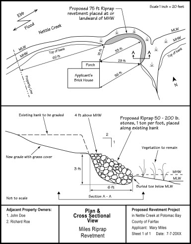
Note that as part of the Joint Permit Application, plan view and cross-section view drawings are required for all projects. Follow instructions on the website carefully. Clear and accurate drawings are essential for project review and compliance determination. Incomplete or unclear drawings may cause delays in the processing of your application.

In addition, applicants must file a Supplementary Information Form, which is required by the Wetlands Board, pursuant to Va. Code Ann. §§ 28.2-1302.4B.,and Ch. 116, Wetlands Zoning Ordinance of the Code of Fairfax County.

Finally, applicants must pay a fee in the amount of $300.00 to Fairfax County to cover the application processing fees, and submit a letter acknowledging that the applicant and/or the applicant’s agent understands that the publication fees for the public hearing will be billed to the applicant or the applicant’s agent, as applicable. This payment will be collected digitally once a completed application is submitted through the PLUS application portal.

CHECKLIST FOR A COMPLETE APPLICATION

plan for a project

  • North arrow
  • Name of waterway
  • Existing structures
  • Benchmarks showing distance to fixed reference points
  • Mean low water and mean high water lines (tidal)
  • Location of vegetated wetlands at the project site
  • Shoreline, property lines, and location of adjacent property owners
  • Ebb and flood (tidal) or direction of the flow (nontidal)
  • Channelward encroachment relative to mean high/mean low water lines
  • Connection with existing bulkhead or riprap structure (if applicable)
  • Proposed backfill
  • Length of revetment

  • Proposed backfill
  • Mean low water and mean high water levels (tidal)
  • Ordinary high water (nontidal)
  • Existing contours of the shoreline and/or bank
  • Dimensions of proposed revetment
  • Filter cloth
  • Buried toe or riprap apron
  • Proposed grading of existing bank relative to mean high water
  • Vicinity map – The name of the map from which the vicinity map was taken and the exact location of the project site must be included (U.S.G.S. quad sheet, street map or county map is preferred).

  1. What will be the average amount of fill material (placed below the plane of mean high water) per linear foot of shoreline? 
  2. How many cubic yards per foot  OR  how many tons per foot?
  3. What type of material will be used for construction of the riprap revetment, such as quarry stone, cinder block, etc.
  4. Estimate the average weight and size of the bottom layer core material.  Estimate the weight and size of the top layer armour material. 
  5. If backfill will be placed landward of the revetment, then describe the composition of the material to be used.
  6. What is the source of the backfill material?
  7. Will any portion of the project be placed on wetlands or subaqueous lands?  If yes, indicate the square footage and the type of area to be affected. 

Contact Information

Fairfax County Wetlands Board

For questions about your proposed project in relationship to the Wetlands Board’s jurisdiction – that area within mean low water and an elevation above mean low water equal to 1½ times the mean tide range – or if you have any questions about filing a wetlands permit application, contact:

Fairfax County Wetland Board Staff
Department of Planning and Development, Planning Division
12055 Government Center Parkway, Suite 730
Fairfax, VA 22035-5504
Phone: 703-324-1380, TTY 711

For Questions About Activities Conducted Below Mean Low Water:

Virginia Marine Resources Commission
Habitat Management
2600 Washington Avenue
Newport News, VA 23607-0756
757-247-2200

For More Information About Activities Conducted in Waters and Wetlands of the United States:

United States Army Corps of Engineers
Northern Virginia Field Office
18139 Triangle Shopping Plaza, Suite 213
Dumfries, VA 22026
703-221-6967


Fairfax Virtual Assistant