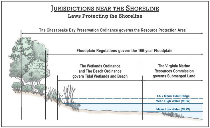
Tidal wetlands are lands contiguous to a tidal body of water and lying between mean low water and mean high water subject to flooding by normal tides and wind tides. Projects that are within the Waters of the United States, including tidal wetlands may be subject to approval by the U.S. Army Corps of Engineers. Projects that are below mean low water, within the tidal wetland, sand dunes or beaches, may require review by the Virginia Marine Resources Commission. Land disturbances and related construction activities within the tidal wetland often require a wetlands permit in accordance with the Wetlands Zoning Ordinance or the Coastal Primary Sand Dune Zoning Ordinance. To facilitate the review by federal, state and local agencies that have overlapping regulatory jurisdiction, a single “Joint Permit Application” may be prepared and submitted for review.
The following types of land disturbing activities and construction projects will require a Joint Permit Application:
Any construction project on, over or adjacent to a body of water.
Any project in which fill material is placed in or near wetlands such as riprap.
Projects designed to protect property at the water's edge.
The floodplain, as defined by Fairfax County, is the land area in and adjacent to streams that have a drainage area greater than 70 acres, and would be inundated by a flood event with a one percent chance of occurrence in any given year (commonly called the 100-year flood). The Federal Emergency Management Agency (FEMA) has delineated Special Flood Hazard Areas (SFHAs). To view mapped floodplain boundaries and other related information use the interactive map. Please note, however, that the County Floodplain Regulations are more stringent than the federal minimum requirements of the National Flood Insurance Program.
The Floodplain Regulations are found in Section 5105 of the Zoning Ordinance. Any Permitted Use in the Floodplain that qualifies requires a request for written determination from Land Development Services (LDS). If not a Permitted Use, Special Exception Uses require an application submission to the Department of Planning and Development with approval by the Board of Supervisors.
RPAs are sensitive land areas that include the tidal shore, tidal wetland, perennial streams, and non-tidal wetlands. The RPA buffer also includes the major floodplains. To view the maps online, visit Chesapeake Bay Preservation Area Maps online.
Removal of invasive or undesirable plant species within a RPA may require a WQIA, 118-3-3(d). Removal of such invasive or noxious plants may involve several techniques including, but are not limited to, the following:
Projects that include the construction of structures (i.e., decks, docks) may require building permits and possibly other construction permits such as electrical and plumbing, in accordance with the Virginia Uniform Statewide Building Code.
Projects disturbing 2,500 square feet or more and land-disturbing activity that is part of a larger common plan of development or sale that disturbs one acre or more, may require approval of a grading or conservation plan prepared by a Professional Engineer and submitted to LDS and issuance of a Land Disturbance Permit in accordance with the Erosion and Stormwater Management Ordinance, Chapter 124.1 of the County Code. More information on site-related plans and site development are available online.
Projects that disturb more than one acre of land or are part of a common plan of development or sale, must comply with the terms and conditions of the state General VPDES Permit for Discharges of Stormwater from Construction Activities which is administered by DEQ.