

Transportation Alert:
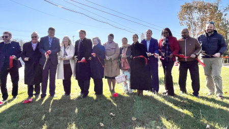 (November 2023) A ribbon cutting ceremony was held November 1, 2023, to celebrate the substantial completion of the Route 28 Widening Project. Despite ongoing construction activities, crucial segments of the project are now open to traffic. While continuing efforts are directed towards pending construction, such as completing the installation of noise barriers, stormwater management facilities, shared-use paths and improvements on a few side streets, the project demonstrates its potential in significantly enhancing regional transportation infrastructure.
The project also enhances travel reliability, facilitating more efficient commutes to major commercial and employment centers, including Dulles Airport, businesses in the Reston, Herndon, and Dulles Corridors, and Tysons.
Route 28 serves residential and business destinations from Remington in Fauquier County to Route 7 in Loudoun County, connecting Route 29, Route 234, I-66, Route 50, Dulles International Airport and Route 267 in between. The corridor has experienced increased congestion for many years, particularly in Prince William and Fairfax Counties south of I-66. To address this congestion, the Fairfax County Department of Transportation (FCDOT) proposes widening Route 28 for a distance of approximately 2.3 miles from the existing bridge over Bull Run to the interchange at Route 29. The project includes:
The project was endorsed by the Fairfax County Board of Supervisors as part of the County’s Transportation Priorities Plan (TPP) on January 28, 2014 (Project ID#62).
Fairfax County and the D-B contractor will coordinate with property owners well in advance of construction. Work hours are set by VDOT and Fairfax County. Night work is likely. The D-B contractor will be required to maintain pedestrian and vehicular traffic and signals during construction. No lane closures will be allowed during peak travel hours.
FCDOT ensures nondiscrimination in all programs and activities in accordance with Title VI of the Civil Rights Act of 1964 and the Americans with Disabilities Act (ADA). If you need this information in an alternate format or would like to request reasonable accommodations for persons with disabilities or limited English proficiency, contact FCDOT at 703-877-5600, TTY 711. Requests for assistance must be received at least 7 business days in advance of an event.
(October 2024) On Oct. 31, 2024, VDOT issued a c% Certificate of Completion for the project construction. The contractor will address any maintenance issues on the project during a one year warranty period.
(May 2024) Starting Sunday, April 14 and continuing through May 31, motorists can expect single and double lane closures between the hours of 10 p.m. to 5 a.m. along Route 28 northbound and southbound between the Route 28/Route 29 interchange and the Fairfax County/Prince William County line to facilitate final paving. Please follow police direction. This work is weather dependent and dates are subject to change.
(April 2024) On Sunday, April 7 to Friday, April 12, motorists can expect single and double lane closures between the hours of 10 p.m. to 5 a.m. along Route 28 southbound between the Route 28/Route 29 interchange and New Braddock Road to facilitate storm sewer installation. This work is weather dependent and dates are subject to change.
(March 2024) Starting on or about Sunday, March 17, motorists can expect nighttime single lane closures on Route 28 to facilitate post installation inspection of storm sewer systems.
(February 2024) As part of the Route 28 (Centreville Road) Widening design-build project, the median will be closed Sunday, Feb. 25 through Thursday, Feb. 29, from 10 p.m. to 5 a.m. In addition to no left turns across the median, only right in/right out turns will be allowed to and from intersecting streets. Crews will be removing existing signal controller cabinets and installing new cabinets at the intersections of Compton Road, Green Trails Boulevard/Old Mill Road, New Braddock Road, Machen Road and Upperridge Drive/Old Centreville Road.
Please use caution when approaching these intersections and follow police direction. The construction schedule, which is subject to change, includes:
Please click on the links for each intersection to preview traffic flow.
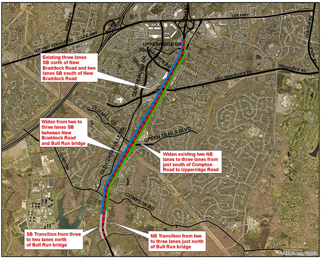
(October 2023) Starting on or about Thursday, Oct. 5, motorists can expect new traffic patterns along Route 28 between the Fairfax County/Prince William County line and Old Centreville Road. The new traffic pattern will add an additional lane northbound and southbound, providing three traffic lanes in each direction. All northbound lanes are expected to be open by Thursday afternoon October 5. Southbound lanes should be open no later than Monday afternoon October 9.
Please note: Shoulders will still be closed as ongoing construction continues.
Through Spring of 2024, motorists can expect periodic single lane closures on Route 28 in both directions during off-peak hours (9:30 a.m. to 3 p.m., Monday through Thursday; 9:30 a.m. to 2 p.m. on Fridays) to complete remaining work in the corridor.
Temporary message boards have been placed on Route 28 northbound and southbound to help alert drivers to the changes. Final completion is anticipated for Spring of 2024.
(September 2023) Night work with temporary lane closures has been rescheduled for the nights of Wednesday, Sept. 27 and Thursday, Sept. 28, for signal and ITS (Intelligent Transportation Systems/computers and communications) work. This work is weather dependent and subject to change.
Erection of signal poles at the intersections of Route 28 and New Braddock Road and Route 28 and Machen Road will require single lane closures on Route 28 southbound between the hours of 10 p.m. and 5 a.m., with up to 20 minute stoppages of Route 28 between the hours of 12 and 4 a.m. (Thursday and Friday mornings). The intersection will be under police direction during the operation.
Erection of a new dynamic message sign/structure and demolition of the existing dynamic message sign/structure will require single lane closures along Route 28 northbound between the hours of 10 p.m. and 5 a.m. with up to 20 minute stoppages of Route 28 between the hours of 12 and 4 a.m. (Thursday and Friday mornings).
(July 2023) Construction is underway in the New Braddock Road median east and west of Route 28. This part of the project will provide approximately 300 feet of dual left turn lanes and 300 feet of a single right turn lane on eastbound New Braddock Road west of Route 28, in addition to the two existing through lanes.
On westbound New Braddock Road east of Route 28, approximately 300 feet of triple left turn lanes and 300 feet of a single right turn lane will be constructed, in addition to the two existing through lanes.
(July 2023) Construction is about to begin on Noise Barrier D1, located on the northbound side of Route 28 immediately south of New Braddock Road. The contractor plans to begin setting sound wall posts on July 26, weather permitting. Construction on the sound walls south of New Braddock Road will continue through the summer.
(June 2023) As part of the ongoing Route 28 Centreville Road construction, Shirley Contracting will install permanent signal poles and signal mast arms June 28 and 29, 2023. The night work, scheduled between 10 p.m. and 5 a.m., will impact the intersections of Route 28 with New Braddock Road and Green Trails Boulevard/Old Mill Road. Work will be conducted at one intersection each night and will require closure of the Route 28 median. No left turns will be permitted from Route 28 northbound and southbound. Traffic on the intersecting streets will be limited to right out/right in movements to and from Route 28. Limited 20 minute temporary stoppages of Route 28 will be required for this work between the hours of 12 and 4 a.m.; ony one direction will be affected per stoppage. During the operation, the intersection will be under police control.
See the attached maps for closures and detour information. Please note this work is weather dependent:
(May 1, 2023) Shirley Contracting plans full roadway closures for the installation of traffic signal mast arms on Route 28 at the following intersections, no earlier than 10 a.m. to no later than 2 p.m., on weekdays beginning Wednesday, May 3 through Tuesday, May 9, as necessary:
Closures will not occur simultaneously at more than one intersection.
In addition, directional closures will not occur simultaneously on both Southbound and Northbound Route 28, and shall be limited to the following times:
Each full stoppage shall be as short as possible, not to exceed five to 10 minutes in total duration. If excessive traffic back-ups and/or queuing routinely develops, the remainder of the mast arm installations requiring full closures may be rescheduled to the applicable allowable nighttime hours.
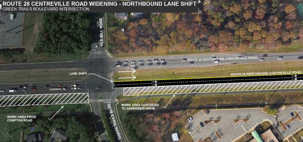
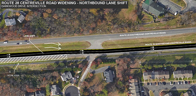
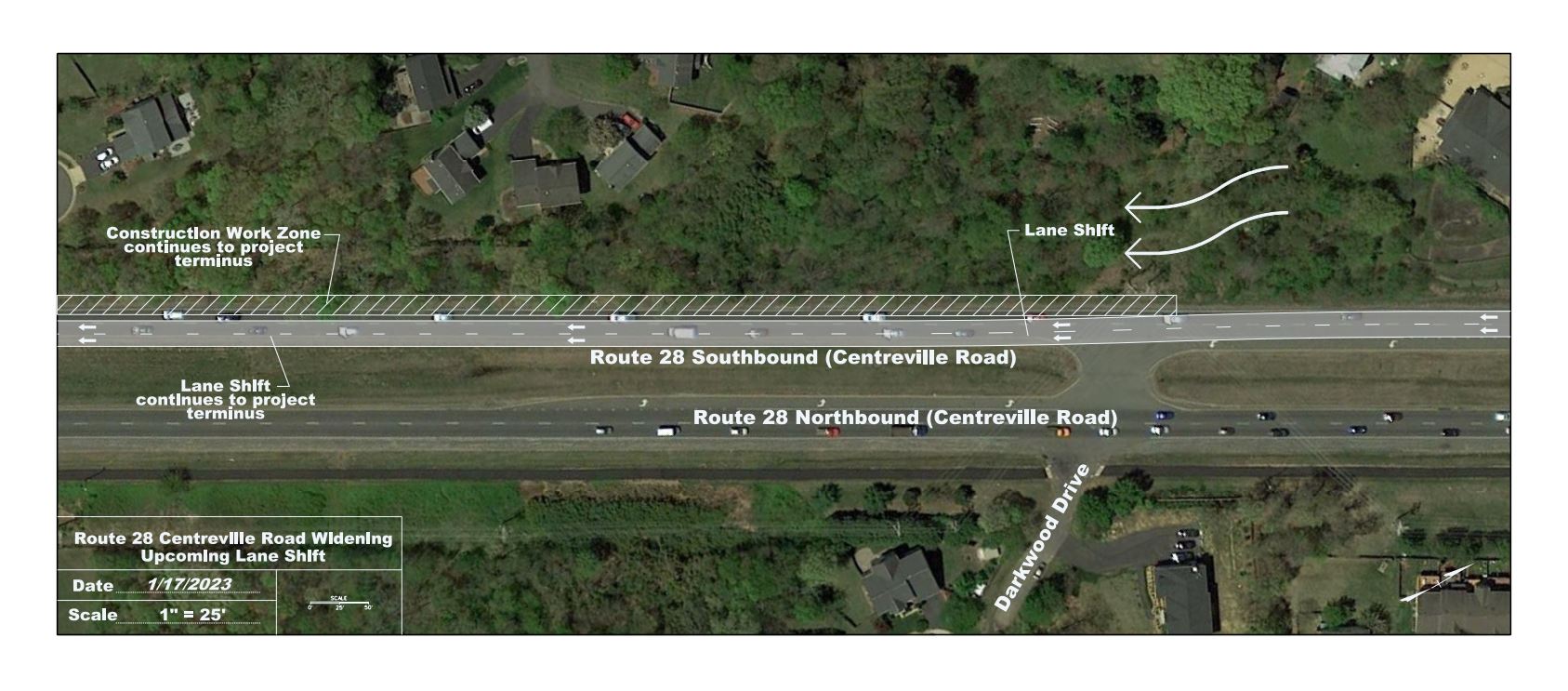
(March 2023) As part of the ongoing Route 28 widening construction, an upcoming lane shift is scheduled for Wednesday, March 1. The new lane configuration will shift traffic along northbound Route 28 at the Green Trails Boulevard intersection towards the median, and transition traffic back to its current configuration at Darkwood Drive. The new lane configuration will continue to provide two through lanes northbound and turn lanes at signalized intersections. Please be alert and aware of ongoing construction on the project.
(February 2023) As part of the ongoing Route 28 widening construction, two upcoming lane shifts are scheduled for February. The new lane configuration will continue to provide two through lanes southbound and turn lanes at signalized intersections. Please be alert and aware of ongoing construction on the project.
(November 2022) On or about Wednesday, November 2, 2022, motorists can expect delays and modified traffic patterns in the area of Route 28 and Compton Road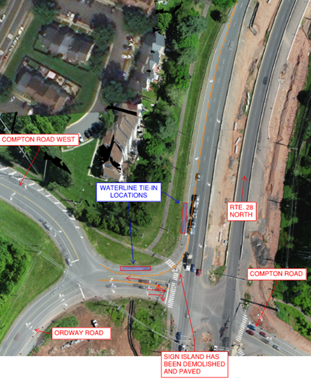 between the hours of 5:00 a.m. and 3:00 p.m. as part of waterline relocation work for the Route 28 Centreville Road Widening Design-Build project.
The contractor shall provide adequate notification and signing for all surrounding/adjacent/directly affected property owners and the general public in advance. Fairfax County Police will be on site to assist in directing traffic, if needed.
This work is weather dependent and subject to change.
(August 2022) - Construction, which began in August 2021, continues on the Route 28 (Centreville Road) widening between the Bull Run bridge and Old Mill Road/Green Trails Blvd., and has moved north to New Braddock Road. Ongoing construction work includes clearing and grubbing, to be followed by grading, paving, and installation of storm sewers; curb and gutter installation; and paving. Construction will require intermittent lane closures during off-peak hours. Night work will occur. The shared use path along Route 28 South will be closed from the Bull Run bridge to Compton Road.
All work is weather dependent and will be rescheduled if inclement conditions occur.
(July 2022) - FCDOT posted drone footage of the project on its Facebook page - please check out this bird's eye view of Route 28!
(December 2021) - Shirley Contracting Company will close the northbound left turn lane at the Route 28/Bradenton Road intersection (from station 132+00 to 137+00) for at least nine months effective Friday, Dec. 17, 2021. This duration may be adjusted depending on progress in that area.
The median break at Bradenton Road, and the southbound Route 28 left turn lane, will both remain open. View plans here.
The 2016 traffic study for the Route 28 project documented just one U-turn here in the AM peak hour and two in the PM peak hour. There are no driveways on either northbound or southbound Route 28 between Compton Road and Bradenton that would require residents to make a U-turn at this location.
FCDOT will monitor traffic conditions and adjust this closure accordingly. Please contact the project team by using the red feedback form button at the bottom of this page or by calling the project team at 703-877-5600.
(Nov. 1, 2021) - Route 28 Shared Use Paths Update
The Virginia Department of Transportation (VDOT) authorized the award of the Route 28 Widening Project contract on May 12, 2020, to Shirley Contracting Company, LLC, based on their bid of $56,882,900. Fairfax County approved the award of the contract on May 22, 2020.
Statements of Qualifications for the RT 28 Design-Build project were received from the following firms on May 24, 2019. Technical proposals were received from short listed firms on March 6, 2020. Price proposals were received from the short listed firms on March 27, 2020.
| Offerers | Short List | Final Ranking | Contract Awarded |
|---|---|---|---|
| Archer Western/STV | Branch/RDA | Shirley/Dewberry | Contract Award |
| Branch/RDA | Lane/RK&K | Branch/RDA | |
| Fort Myer/Volkert | Shirley/Dewberry | Lane RK&K | |
| Lane/RK&K | |||
| Shirley/Dewberry |
FCDOT used the Design-Build (D-B) procurement method to deliver the project. D-B allows for more rapid implementation of projects by combining and overlapping the design, right-of-way, utility relocation and construction phases.
Design plans have progressed to approximately 90%. This preliminary design provides for the widening of Route 28 between Compton Road and Route 29 to a six lane divided highway, while not to precluding a future widening to 8-lanes. FCDOT completed a draft report of the traffic analyses to determine the optimal number of lanes that will be required to provide an acceptable traffic flow in the future. For additional information on the traffic analysis, see the Traffic Analysis and Widening Options
Please note: These plans are preliminary and are subject to change as the design progresses. Additional easements may be needed for utility relocation and potential noise walls. Potential noise wall locations are shown on the plans. Typical sections do not illustrate all conditions along the proposed roadway alignments.
The County’s Comprehensive Transportation Plan describes Route 28 as eight lanes with High Occupancy Vehicle (HOV) lanes, and a future interchange at New Braddock Road. The project design will not preclude future widening to eight lanes, future HOV or a future interchange at New Braddock Road.
FCDOT completed the noise barrier evaluations and voting for the Route 28 project, in accordance with VDOT requirements. Based on survey votes received from owners and residents of benefited receptors, the project constructed proposed Noise Barrier Walls D1, E1, I1/I2, and J1.
All barriers were constructed using the Virginia Dry Stack Architectural Treatment pattern and will be stained/painted Light Brown (FS 37150).
FCDOT held a virtual stakeholder meeting for the Route 28 Widening project on Wednesday, May 11, 2022, to update the community on the status of the project, upcoming construction activities, and to discuss the project land acquisition schedule and process. Staff from FCDOT and Shirley Contracting Company led a question-and-answer session after the presentation.
Comments were accepted through May 25; please use the red Feedback Form button at the bottom of this page to contact the project team.
FCDOT held a virtual stakeholder meeting for the Route 28 Widening project on Dec. 2, 2021, at 7 p.m., to update the community on the status of the project, upcoming construction activities, and to discuss the project land acquisition schedule and process. Staff from FCDOT and Shirley Contracting Company were available to answer questions.
held a virtual community information meeting on the widening of Route 28 from the Prince William/Fairfax County Line o Route 29 on Thursday, June 17, at 7 p.m. The purpose of the meeting was to update project status; discuss the Land Acquisition process; and present the findings of the Final Noise Analysis and discuss noise barriers proposed with the project.
Comments will be accepted through Friday, July 9, 2021. To send questions and feedback:
The Fairfax County Department of Transportation (FCDOT) held a “Pardon Our Dust” virtual meeting on Tuesday, Oct. 27, 2020, at 7 p.m., to present the plans for initial construction of the Route 28 widening project.
The project will widen existing Route 28 from four to six lanes from just north of the bridge over Bull Run to the interchange at Route 29. The meeting provided more detail on the project’s final design and construction schedule, including initial construction work that is anticipated to begin in 2021. This initial work will be limited to temporary shoulder widening along both the northbound and southbound roadways between the Bull Run bridge and Route 29 to provide space for lane shifts. The project plans to maintain two lanes of travel in each direction during peak hours when the full roadway construction begins, which is anticipated in late Spring/early Summer 2021.
The meeting provided more information on the project’s final design and construction schedule and included an opportunity for questions from the public.
FCDOT held a Design Public Hearing for the Route 28 Widening Project on Monday, Sept. 23, 2019, 6:30 - 9 p.m., in the cafeteria of Centreville Elementary School, 14330 Green Trails Blvd., Centreville. A formal presentation was held at 7 p.m., and presentation materials are posted below:
The Full Plan Set (51 MB) is available by contacting the project team by using the feedback button below or by calling 703-877-5600, TTY 711. The comment period for the Route 28 Widening Project closed Oct. 7, 2019.
In accordance with the National Environmental Policy Act (NEPA) and 23 CFR 771, a Categorical Exclusion (CE) was prepared in cooperation with the Federal Highway Administration (FWHA) for the project. The CE was submitted to VDOT on July 15 and on FWHA found the Draft NEPA Documentation to be acceptable to support the original Categorical Exclusion determination on July 19, 2019.
Summaries of the technical documentation on historical resources, the preliminary noise analysis and correspondence are posted below:
For more information on the Categorical Exclusion and technical documents, please contact the project team by using the feedback button below or calling FCDOT at 703-877-5600. The deadline for comments regarding the Categorical Exclusion closed on Sept. 25, 2019.
Presentation and meeting information for previous community meetings on the Route 28 widening project are listed below:
VDOT Project Number:
0028-029-269, P101, R201, C501
VDOT UPC: 108720
FCDOT Project Numbers:
Fund 40013: 2G40-136-000
Fund 40017: 2G40-100-000
Fund 50000: AA1400143-17
Federal Project Numbers:
P101: NHPP-5A01(810)
R201: NHPP-5B01(078)
C501: NHPP-5B01(079
The proposed Design-Build project schedule includes:
For more information, see the Alternative Delivery Methods and Schedule Comparison.
Completed Tasks:
The section of Route 28 between the Prince William County/Fairfax County line (at the bridge over Bull Run), and the existing interchange at Route 29 is a four-lane divided highway that currently carries approximately 60,000 vehicles per day (vpd). Between Route 29 and New Braddock Road, the southbound side of the roadway is currently three lanes wide. Along this 2.3 mile segment, there are five signalized intersections located at Compton Road, Old Mill Road/Green Trails Blvd., New Braddock Road, Machen Road and Upperridge Drive/Old Centreville Road. In addition, there are three un-signalized median crossovers (one U-turn south of Compton Road, Bradenton Drive and Darkwood Drive), and one right-in/right-out intersection on the northbound side of Route 28 (Tallavast Drive).
Traffic counts were collected in 2016 and analyzed to determine the operational characteristics of the Route 28 corridor under existing conditions. During the AM peak period, one signalized intersection operates at Level of Service (LOS) F (New Braddock Road), and two operate at LOS D (Compton Road and Upperridge/Old Centreville). Based upon field observations, the queues generated by these poorly operating intersections result in spill back to upstream intersections throughout the length of the corridor. In the AM, these queues spill back well into Prince William County. During the PM peak period, three intersections operate at LOS F (New Braddock Road, Machen Road and Upperridge/Old Centreville) and one other signalized intersection operates at LOS E (Compton Road.) Queue spill back during the PM peak severely degrades operations at upstream intersections, however, the spill back rarely impacts or affects operations at the Route 28/Route 29 interchange or the interchange on Route 28 at I-66.
A study completed by VDOT in 2015 of the safety and operational characteristics of Route 28 between Liberia Avenue (in the City of Manassas) and just south of I-66 provides confirmation of the operational deficiencies found along Route 28. The VDOT report indicated average AM peak period travel times between Liberia Avenue and I-66 of 46 minutes, and average PM peak period travel time of 18 minutes to cover this approximately six (6) mile distance.
Please note: Some sections below reference Levels of Service or “LOS.” Level of Service is a measure of the relative quality of traffic congestion, based on performance measures such as traffic speed and density. LOS “A” is free flow of traffic; LOS “F” is breakdown flow or gridlock.
FCDOT began preliminary design on the project in 2016. The initial project scope proposed widening Route 28 from a four lane divided roadway to a 6-lane divided roadway with a shared use path on both sides of the roadway. The initial traffic analysis for a 6-lane section indicated that traffic volumes in the year 2040 would result in LOS F at one intersections (Compton Road) during the AM peak period. Three of the five intersections were expected to operate at LOS E during the PM peak period. As under existing conditions, queue spill back from these poorly operating intersections is anticipated to degrade operations of the upstream intersections. The anticipated growth in traffic volumes reduced or eliminated any benefits of the proposed widening. Congestion in both directions was due to inadequate capacity; but congestion in the southbound direction (at the PM peak) was also caused by queue spill back from heavy volumes on Route 28 to the south of the FCDOT widening, in Prince William County.
As a result of this initial analysis, FCDOT performed a series of traffic analyses on several possible lane configurations for Route 28 in order to optimize the proposed improvements and traffic operations along the corridor. These concepts included; 1) widening Route 28 to seven (7) lanes (4-northbound, 3-southbound); 2) widening Route 28 to eight (8) lanes (4-lanes northbound and southbound); and 3) a hybrid of the original scope and concept 1 and 2 (6-7-8 lanes). Based upon the results of the traffic analysis, FCDOT selected the Hybrid 6-7-8 lane Option as the preferred design as it met the anticipated traffic demand and achieved the desired traffic operational results while minimizing costs and impact to the community and environment.
In early 2018, FCDOT submitted a request to NVTA for additional funds to complete project funding for the Hybrid 6-7-8 lane option. Due to the Virginia General Assembly’s reallocation of funds from NVTA to WMATA, , when NVTA’s FY 2018-2023 Six Year Program was approved on June 14, 2018, only $16 million was awarded to the project. As a result of this reduced funding, the County was forced to reassess what improvements could be completed with available funds. Thus, instead of building the preferred Hybrid 6-7-8 lane option, the project is now limited to building only 6-lanes at this time . It should also be noted that an additional $7,794,999 in local funds has been allocated by the County in order to construct 6-lanes.
The traffic analysis was updated in October 2018 to evaluate traffic operations of the Route 28 6-Lane design alternative in the anticipated opening year, 2023, and the future design year 2040. The study was to determine if the additional lanes in each direction on Route 28, as well as other intersection improvements, were sufficient to provide acceptable operations in the Opening Year 2023; the resultant operations in the future design year 2040, and determine when additional improvements above and beyond the 6-lane design would be required. Each intersection analyzed in this study was improved to nearly the maximum extent practical using conventional intersection layouts.
A VJUST (VDOT Junction Screening Tool) analysis was also performed to evaluate alternative intersection designs. This analysis found that based on operating characteristics, construction constraints and right-of-way constraints, alternative intersection designs, while technically feasible, provided neglible benefits and were thus not cost effective.
The results show that the 6-lane design will provide for reasonable traffic operations in the Opening Year 2023: All the intersections on the Route 28 mainline corridor within the study area are expected to operate better than or approximately equal to existing conditions in both the AM and PM peak periods. Only one intersection(New Braddock during the AM peak) is expected to operate at LOS E in 2023, with all remaining intersections operating at LOS D or better. The results also identify average and maximum queuing, and provide input regarding the recommended turn bay lengths for the design.
In the 2040 6-Lane Build Alternative, one intersection (New Braddock) is expected to fail in the AM peak (with an LOS of F); no intersections are expected to fail in the PM peak. In the PM peak in 2040, three intersections are expected to operate at LOS E conditions, with a fourth at borderline LOS D/E conditions. The results indicate that the 6-Lane Build alternative shows an improvement to LOS, delay, and travel times as compared to the No-Build condition. Through the analysis, it has been determined that, based upon estimated travel time results, the 6-Lane alternative will potentially fail by the year 2040, and Route 28 would operate with similar travel times as existing conditions. It is estimated that additional widening, either to the 6-7-8 lane Hybrid option or to 8-lanes will be required sometime between 2035 and 2040.
Due to the reduced project funding, FCDOT is now proceeding with a phased approach to provide the roadway as a 6-lane section, with a design that will not preclude future widening to an 8-lane section as called for in the County’s Comprehensive Transportation Plan. The traffic analyses indicate that the 6- lane section will provide a sufficient and acceptable operations in the opening year of 2023. However by 2040, the 6-lane section will operate with similar travel times as existing conditions. VDOT Northern Virginia District staff have indicated they support the County’s plan to construct the 6-lane option as an interim (phased) widening in the corridor. The County intends to continue to pursue funding in the future to widen Route 28 to an eventual 8-lane facility and to construct needed improvements prior to failure of the 6-lane alternative.
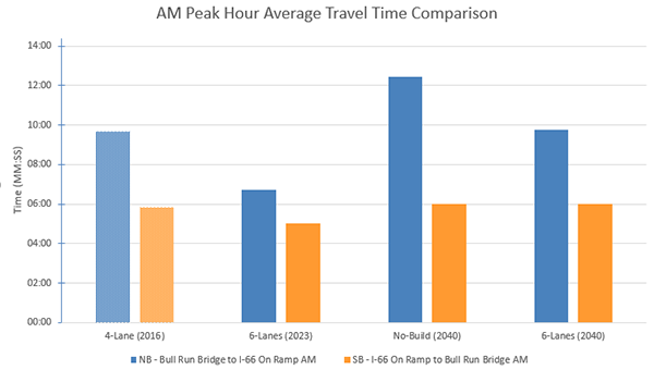
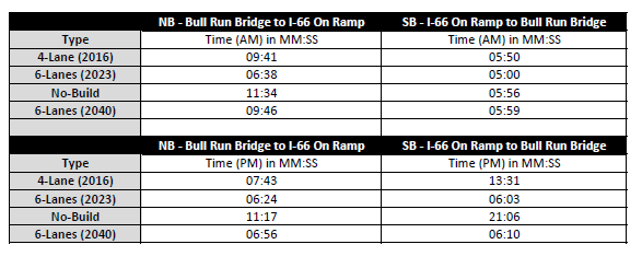
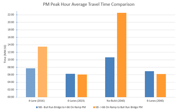
This table compares average intersection delays and Levels of Service (LOS) at each signalized intersection in the corridor based on :
The table also shows corridor travel times based on the traffic analysis.
Following the results of the traffic analysis, FCDOT developed concept level plans (approximately 15% complete) for an 8-lane widening of Route 28 between Compton Road and Route 29. The 8-lane concept level plan was utilized as a “base line” to evaluate various factors, including but not limited to: total project cost, right-of-way, design, construction, schedule, risk, environmental impacts and mitigation, utility relocation, maintenance of traffic, and constructability. This concept design was further developed to a Preliminary 30% plan for a 6-lane widening, based on the ultimate 8-lane design. The 6-lane design allows future widening to be constructed in the median. No additional right-of-way should be required for future widening to an 8-lane section.
These plans are preliminary and are subject to change as traffic analyses are refined and design progresses. Additional easements may be needed for utility relocation and potential noise walls. The plans indicate the locations of potential noise walls, based on the noise analysis.
The 8-lane section, as presented, represents the “worst” case scenario for the proposed improvements to Route 28, and as such, is representative of the anticipated maximum impacts that may result from the proposed roadway widening.
The preliminary 6-lane plan widens the northbound roadway by adding one lane to the outside. South of New Braddock Road, the centerline of the southbound roadway is shifted approximately 5 feet toward the median. Widening to add one additional southbound lane is constructed on both the outside and inside of the southbound roadway.
On the northern end of the corridor, north of New Braddock Road, both the northbound and southbound roadways are proposed to be closed sections, with curb and gutter and closed drainage systems. South of New Braddock Road, a shoulder section is proposed on the outside of both the northbound and southbound lanes. However, curb and gutter is proposed along all left and right turn lanes. The proposed outside shoulder section is a safety feature providing safe pull off areas for vehicle breakdowns, accidents, and police enforcement areas.
Future widening to an 8-lane section would add one lane to the inside (or median side) of each roadway. A raised median, with median curb, is proposed along the entire length of the corridor as part of the future widening. Due to the existing differences in elevation between the northbound and southbound lanes, retaining walls will be required in the median at several locations.
Because of the increase in impervious area, storm water management facilities will be required to control storm runoff water quality and quantity. The preliminary storm water management design, as shown, is based upon the ultimate eight-lane configuration of Route 28 and upon preliminary calculations of storm water management requirements in accordance with Fairfax County storm water management criteria. Potential storm water management facilities necessary to meet these requirements are shown on the concept plan, and are located on vacant parcels adjacent to the project.
The project may also improve traffic operations between Compton and Ordway Roads and Route 28. The options initially under consideration included an additional left turn lane from eastbound Compton Road to northbound Route 28, and additional right-of-way of varying amounts depending on the option. The options include:
Preliminary traffic analyses indicated that only Options 1 and 4 provided significant improvements to traffic flow. Due to funding constraints, the Request for Proposal (RFP) includes Option 1 only.
The Prince William County Department of Transportation and the Prince William County Board of Supervisors continue to study the Route 28 Bypass project. FCDOT and the Fairfax County Board of Supervisors remain committed to working with Prince William County to develop regional solutions to the area's transportation challenges.
The Prince William County Department of Transportation hosted two community meetings to update residents in both Fairfax and Prince William counties about the Route 28 Bypass project. Meetings were held on April 19 at Centreville Elementary School and April 20 at the Manassas Park Community Center. Meeting videos and presentation are available on the project webpage.
Prince William County hosted a virtual information session on Monday, Dec. 7, 2020, at 7 p.m., to inform residents of both counties about the Route 28 Bypass Project, including proposed concepts for the Route 28 Bypass connection and tie-in point to existing Route 28 in Fairfax County. Details and meeting recording will be available at http://route28bypass.com/.
Prince William County (PWC), the City of Manassas, and the City of Manassas Park, in cooperation with VDOT, are presently preparing an Environmental Assessment (EA) to evaluate the potential social, economic, and environmental effects associated with proposed improvements in the Route 28 corridor between Sudley Road in Prince William County and Compton Road in Fairfax County. Information on this study is available at www.route28study.com.
The EA will evaluate three alternatives developed in the December 2017 Route 28 Corridor Feasibility Study. Limited funding is available for this project and no date has been proposed for construction[MWT2]. No major capacity improvements to Route 28 south of the Bull Run bridge are expected to be complete before 2025.
FCDOT’s Route 28 widening project does not preclude the construction of any of the alternatives in the Prince William County study.
Right of way acquisition for the project was completed in 2023. The project did not require any relocation sor displacements of residents or businesses.
Since the proposed widening takes advantage of the wider right of way available on the northbound side of the roadway, and the southbound centerline is proposed to be shifted approximately 5’ towards the median, right of way requirements for the roadway widening were minimized. Right-of-way required for the road widening itself were partial property takes of five to twenty feet in width, abutting the existing right-of-way on Route 28 and intersecting streets. Additional easements were required for utility relocation, particularly along the southbound side between New Braddock Road and the bridge over Bull Run, and for sound barrier walls.
Storm water management (SWM) for the project required acquisition of several larger parcels (which may include full takes) outside the existing right of way. FCDOT required the Design Builder to prepare a design and acquire adequate right-of-way for storm water management facilities to serve the ultimate eight-lane section.
If future funding becomes available, the realignment of the Compton/Ordway/Old Centreville Road intersection may require partial or full takes of several adjacent properties, depending on the final design.
With the exception of the land rights required for storm water management facilities, the ultimate eight-lane design can be designed and constructed without significant additional right-of-way requirements beyond the initial 6-lane section. The six-lane widening project will acquire adequate right of way for the widening of the ultimate 8-lane design even though the design will be for 6-lanes in the interim.
FCDOT delineated utilities within the project site and excavated 76 test holes at locations where potential utility conflicts may exist. FCDOT held a Utility Field Inspection (UFI) in August 2017 with affected utilities. Additionally, using recent 30% design plans, FCDOT will be conducting more detailed UFI meetings with each individual utility company in February and March 2019. The Design Build contractor also excavated additional test holes and coordinated with the utility companies for protection and relocation of existing facilities during construction. The project included extension of a water main along Route 28 for approximately 1,000 linear feet south of Compton Rad to provide fire protection and domestic water service to existing homes.
Utilities with facilities in the project area include:
FCDOT is prepared a Categorical Exclusion (CE) level evaluation to determine the level of environmental impacts, determine the types of permits and approvals required, and undertake coordination with appropriate environmental resource agencies and permitting agencies.
This work included field studies for archaeological, historic standing structures, and other historic resources (i.e. battlefields), noise and air quality, and wetlands and waterbodies; and evaluations of socioeconomics (including Environmental Justice), Section 4 (f) and Section 6 (f), natural resources including protected species, agricultural/open space, hazardous materials, and cumulative and indirect effects. The work is being performed in accordance with Federal and State environmental regulations pursuant to the National Environmental Protection Act (NEPA). The Final CE was submitted for VDOT and FHWA review in late February and will be posted to the website upon final FHWA approval.
The evaluation includes the areas within and adjacent to the existing VDOT right-of-way that may be affected by the roadway widening; and sites that have been identified as potential storm water management (SWM) facilities.
The study found no areas of cultural or historical significance within or immediately adjacent to the existing VDOT right-of-way. Six wetlands and five Waters of the U.S. have been identified within the project corridor and candidate SWM sites. FCDOT anticipates the maximum impact on wetlands will be approximately 0.8 acres; and the maximum impact on Waters of the United States will be about 2,500 linear feet. These impacts were mitigated by the purchase of stream and wetland credits in accordance with state and federal regulations.
The final construction plans show the delineated wetlands and the noise wall locations.
Links to Environmental Documents below:
NEPA documentation concurrence form
Wetland (WET) Classification & Waters of the US (WUS) Classification
Environmental Impact Analysis and Studies
FCDOT conducted preliminary noise analysis per VDOT Noise Policy to determine where project noise levels are projected to exceed established criteria. FCDOT is required to propose noise mitigation. Ten sound barriers were evaluated based on the criteria of feasibility and reasonableness.
Two barriers were found to meet these criteria and will undergo
further evaluation by the D-B contractor (including effectiveness, exact location, length, height) during final design:
Sound Barriers will be constructed only if a majority of the people who are directly benefitted vote in favor of the implementation.
Please see "Noise Barrier Information" above
A Geotechnical Investigation to support the Preliminary Design has been completed. The study includes a Geotechnical Design Report (GDR) consisting of soil borings and pavement cores equivalent to 50% of the requirements by the VDOT Manual of Instructions (MOI). The GDR provides boring logs for roadway pavement, retaining walls, stormwater management facilities, and large drainage pipes/culverts. The GDR also provides the existing pavement core information as well as a preliminary pavement design.
VDOT approved the final report in March 2019.
In recent years, VDOT has employed alternative delivery methods such as Design-Build (DB) to deliver projects on an accelerated schedule. Fairfax County has endorsed the use of the Design-Build method of delivery and has used it on a number of other projects. FCDOT believes that the DB method is a reasonable alternative to consider for this project. FCDOT developed concept schedules for project delivery using both the Design-Bid-Build (DBB) method and the Design-Build Method. Using DB delivery it is estimated that the project could be completed approximately 24-28 months ahead of the standard DBB method.
VDOT’s Transform 66 Outside the Beltway project will reconstruct I-66 to provide two High-Occupancy-Toll (HOT) express lanes and three general purpose lanes in each direction, between Gainesville and the Beltway. Project completion is currently scheduled for Fall 2023. Using the Design-Build method of delivery would enable the Route 28 project to be substantially complete at approximately the same time that the I-66 project improvements become operational.
While FCDOT developed traffic models and cost estimates for the 6, 7, 8, and hybrid 6-7-8 lane concepts, FCDOT assumed that the project schedules for design and construction would be similar regardless of which widening concept was selected, with only minor changes to design and construction time frames. Time frames for completion and estimated costs for utility relocation and right-of-way acquisition for each concept were also assumed to be similar for each widening concept in order to provide comparable estimates.
The Design-Build contract procurement method for this project satisfies the following needs:
FCDOT prepared estimated total project costs using VDOT’s PCES system and information developed during concept design for each design under consideration. For Design-Build project delivery, the PCES system estimates were developed and then imported into the VDOT Design-Build Cost Finance Summary Worksheet. Costs include, but are not limited to; design, construction, anticipated utility relocations, right-of-way, environmental mitigation requirements, construction engineering and inspection, and VDOT oversight. Estimates were developed for Design- Bid-Build delivery for all concept designs. Design-Build estimates were developed for the 7-lane, 8-lane and hybrid 6-7-8 lanes designs.
Estimated Project Costs - Route 28 Widening (2018 Estimate)
| Concept | Design-Bid-Build (DBB) | Design - Build (DB) |
|---|---|---|
| 6 Lanes | $68,400,000 | $76,625,000 |
| 6-7-8 Hybrid Section | $90,500,000 | $91,100,000 |
Current Cost of Route 28 Widening Project is $86,748,000. Sources of funding include:
During the second round of SmartScale project selection, the amount of SmartScale funds received was $32,830,000. The initial SmartScale funding award included the repurposing of $9,407,418 in Federal Demonstration funds. These funds have an obligation deadline of September 30, 2019.
Under a Design-Bid-Build procurement schedule, FCDOT would not be able to satisfy this obligation deadline since the construction advertisement date would be approximately October 2022. However, per discussions with VDOT, the obligation deadline for these funds would be met if FCDOT utilized the Design-Build project delivery method since funds for Design-Build projects are considered to be obligated for construction once the Request for Proposals (RFP) is advertised.
A Design-Build RFP could be advertised in late Spring 2019 which will be well in advance of the September 30, 2019 obligation deadline.
FCDOT anticipates advertisement of a Design-Build RFP in the Summer of 2019.