
Transportation Alert:

FCDOT asks the public to submit any requests for a public hearing regarding the Lincoln Street project on or by April 10, 2026.
Please see the attached notices, which have been published in The Washington Post and El Tiempo Latino:
To submit a request for a public hearing, please send a written letter to Ms. Sonia Shahnaj, Project Manager, Fairfax County Department of Transportation, 4050 Legato Road, Suite 400, Fairfax, VA 22033, on or prior to April 10, 2026.
The Lincoln Street is a new roadway facility connecting Old Meadow Road to Magarity Road in Tysons. The project consists of two 11’ wide lanes road with 6’ sidewalk on one side and 10’ sidewalk on the other side and a roadway bridge carrying the road over Scott’s Run. Additionally, the project includes two mini roundabouts along Magarity Road at Peabody Drive and at Violet Ridge Place and a raised median island between the roundabouts.
The Lincoln Street corridor provides an alternative access route from Old Meadow Road to I-66 and the McLean area, bypassing portions of Route 123. Access is also provided to Westgate Elementary School, and other residential and institutional properties situated in the Magarity Road/Pimmit Hills area.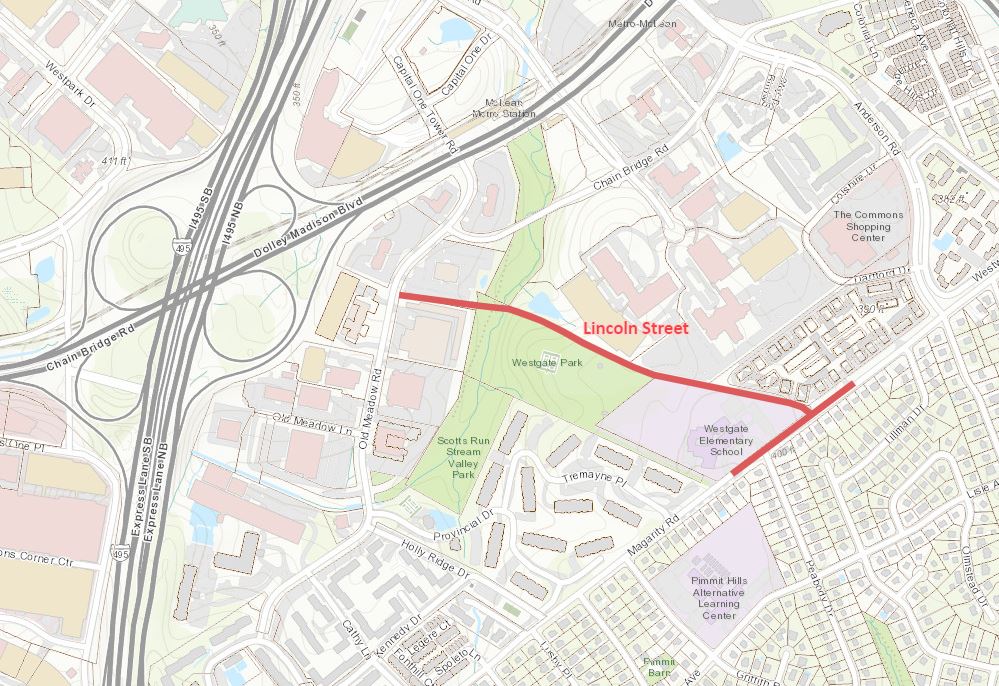
The Tysons Area, particularly Tysons East, is projected to experience substantial growth in the next 40 years. Fairfax County’s traffic studies have focused on developing a refined street network to accommodate growth by distributing traffic across alternative routes and enhancing the urban quality of Tysons through enhancements to multimodal facilities. Lincoln Street is programmed to be a part of this improved roadway network serving Tysons. Click below for additional information.
Nov. 13, 2024, Virtual Meeting
View the Lincon Street Exhibits:
Watch Magarity Road Simulation Video:
The Fairfax County Department of Transportation (FCDOT) has responded to community concern about transportation facilities being constructed on time for new development by moving forward with several capital projects in Tysons, as well as establishing a robust funding plan to ensure an appropriate balance between land use densities and the transportation system. The Lincoln Street grid link is one of these projects and both County and developer traffic studies have shown that a connection between Old Meadow Road and Magarity Road is necessary to ensure other roads such as Anderson Road, Magarity Road and Route 123 can function.
The grid of streets comes from the Fairfax County Comprehensive Plan. Extensive community engagement has occurred in the last 20 years to develop and then update this plan. This history can be found here.
The proposed Lincoln Street is part of the FY2020-2025 Fairfax County Transportation Priorities Plan (TPP) approved by the Fairfax County Board of Supervisors (BOS) on December 3, 2019.
If this connection is not built, other roadways will not function as well, impacting safety, commuter time, walkability, viability of transit options, and ultimately a less functional urban area. Please note, the Board of Supervisors approved developments will be constructed regardless of whether this roadway is constructed, and future development plans would likely look to other solutions to solve mobility issues since the community vision in the Comprehensive Plan calls for Tysons to continue to be densified, with appropriate transportation solutions.
The Tysons East grid of streets network was evaluated and recommended in the 2012 Traffic Study. The study used the Comprehensive Plan land use approved by the Board of Supervisors in 2010. Travel demand assumptions for that study, which assumed high traffic reductions due to telework, technological advances, and other forward-thinking methodologies, are still valid for that analysis.
Lincoln Street will be maintained by Virgina Department of Transportation (VDOT). The design and construction of the new road will be in accordance with VDOT standards and specifications, and all applicable County, State and Federal regulations to ensure safety of the travelling public are met.
The road is classified as a Local Street in the Transportation Design Standards for Tysons Corner Urban Center - VDOT in partnership with the FCDOT. It consists of two 11’ wide lanes road with 6’ concrete sidewalk on one side and 10’ asphalt walkway/trail on the other side with variable buffer width (mostly 6’ where possible). Any deviation from the design standards requires design waiver approval from VDOT and is not guaranteed.
Additionally, Lincoln Street will be designed to accommodate fire trucks and emergency vehicles from Scotts Run Fire Station at Old Meadow Lane, to serve adjacent neighborhoods on Magarity Road including Westgate Elementary School, Union Park at McLean and The Colonies.
Please note, the right-of-way for future Lincoln Street was dedicated by Union Park at McLean, formerly known as McLean Commons development. Please see attached Plat in Exhibit A for reference.
Lincoln Street Connection at Magarity Road:
At the intersection of Lincoln Street and Magarity Road a series of existing private access points on the east side of Magarity Road presents access management and safety challenges, in the case of a traditional stop-controlled or signal-controlled intersection. A feasibility study was completed by FCDOT in 2022 to evaluate alternative options to address the location and continued operation of driveways within the influence area of the new Magarity Road/Lincoln Street intersection.
FCDOT held two public information meetings on the feasibility study in May 2022 to discuss the project background, staff recommended alternative, and the concept plan based on the study.
The study considered eight alternative options including a signalized three leg intersection (T-intersection) at this intersection. However, this option was unacceptable by VDOT. According to VDOT the proposed configuration of the new intersection with a signal is a safety and operational concern. In addition, an estimated three properties would need to be acquired along the southeast side of Magarity Road to remove driveways within and immediately adjacent to the proposed signal.
Dual Mini Roundabouts:
This option was recommended by FCDOT and VDOT as the best alternative to address the operational and safety issues and to minimize disruption to the residential properties and cost to the project.
It includes an unsignalized T-intersection between Lincoln Street and Magarity Road, where access to and from Lincoln Street is right-in and right-out. The mini roundabouts will be located at Magarity Road/Peabody Drive and at Magarity Road/Violet Ridge Place intersections with a raised median between them.
The use of dual mini roundabouts on the Magarity Road corridor is recommended based on the following factors:
Mini Roundabout at Magarity Road/Peabody Drive:
Roundabouts have been included in FHWA’s Proven Safety Countermeasures initiative, a collection of countermeasures and strategies effective in reducing roadway fatalities and serious injuries on highways. The mini roundabout at Magarity Road/Peabody Drive would act as a traffic calming measure and provide a safer environment for school children and their parents than a stop-controlled intersection.
While initial public acceptance of roundabouts has often been a challenge, surveys conducted by the Insurance Institute for Highway Safety (IIHS) reported a positive public attitude after construction (63% of the responses were positive or very positive) versus before construction (41% of the responses were strongly opposed). Additionally, this would not be the first roundabout installed near a school in Northern Virginia. Exhibit B shows a roundabout next to Clarke County High School and D. G. Cooley Elementary School in Berryville, Virginia.
Additional Crosswalk Recommendation:
The current design is in the early stages of development – it is only 30% complete. The County will evaluate the need for additional pedestrian crosswalk on proposed Lincoln Street as the design progresses.
Lighting:
The lighting for the proposed Lincoln Street will be designed in accordance with Tysons Corner Urban Design Guidelines. The design will also adhere to Fairfax County’s Public Facilities Manual for Tysons Design Guidance and Criteria for Non-Standard Streetlights Along Public Right-of-Way. A warmer color temperature luminaire will be installed to minimize light pollution.
Speed Limit Enforcement:
The proposed Lincoln Street will be maintained by VDOT. Additional traffic calming measures on a VDOT road are generally only warranted once a study has demonstrated the need. The study will not be able to determine the need without actual data showing an existing problem. If speeding becomes an issue, the community will have the opportunity to reach out to the County/VDOT to evaluate additional measures, under the programs listed below.
Also, the project will evaluate the option to install additional signage such as, Watch for Children and/or Person with Disability Area, if applicable, as per VDOT’s guidance.
Magarity Road Parking Impact:
Approximately ten (10) parking spaces on Magarity Road will be eliminated by the project (eight (8) spaces east of the school parking lot entrance along the north side and two (2) parking spaces along the south side of the road at Violet Ridge Place).
Below is response from FCPA on additional land acquisition.
Park acquisition and development are considered as part of all rezoning applications, consistent with the County Comprehensive Plan. Under the Comprehensive Plan, the Tysons Urban Center is subject to the Urban Parks Framework, which calls for new developments to provide 1.5 acres or urban parkland per 1,000 residents and 1.0 acres of urban parkland per 10,000 employees. Staff have and will continue to negotiate with developers to provide additional publicly accessible parkland that enhances connectivity with existing parkland in Scotts Run (much of which is already proffered under existing rezoning approvals but has not been built out yet).
The County completed a topographic survey including tree information within the proposed Lincoln Street project area. As the design progresses, a detailed plan will be developed to address tree impact. The plan will be developed in coordination with a professional arborist to evaluate existing trees for their potential to be preserved. Impacts to trees will be minimized and mitigated in accordance with tree conservation guidelines set forth in Section 12-0000 of Fairfax County’s Public Facilities Manual.
Tree Planting:
The roadway design is subjected to a multitude of site constraints - proximity of storage building/ parking lot at/near Old Meadow Road, existing Scotts Run trail bridge, detention ponds/multi-story garage on Northrop Grumman property, rolling terrain along Westgate Park/ elementary school south of proposed Lincoln Street and MITRE parking lot/town home community on the north side. Rolling terrain and limited right-of-way requires retaining walls at Old Meadow Road and along the school to limit impacts to adjacent developed properties. Planting trees along the proposed road will require additional land rights than what is shown on the proposed design. The goal is to minimize limits of disturbed areas (and land rights) to preserve existing trees to the maximum extent possible.
Planting trees/landscaping within the buffer between the sidewalk/trail and road, poses challenges due to utility conflict (electrical service, storm drainage system etc.) and long-term maintenance. However, the County will investigate the possibility of planting trees in the buffer area as design progresses.
Please note, compensation for tree loss on park, school and private properties will be provided through monetary reimbursement which can be utilized for tree replacement by the owners.
Privacy Barrier:
The County acknowledges that the roadway project will require removal of several trees which appear to be within a dedicated right-of-way along northwest side of Union Park at McLean. All impacts to the property will be compensated at fair market value. There is no barrier such as fence, wall, or gate that is located on the property that our project disturbs. For this reason, we are unable to compensate/provide funding or construct a barrier with the project.
Also, the approved plan by the County for Union Park at McLean, formerly known as McLean Commons development, calls out for planting new trees along future Lincoln Street as shown in attached Exhibit D. The development is required to plant trees as per the approved plan.
Wildlife in the project vicinity can be divided into two categories, those species that are afforded legal protection by virtue of their special status, and those species which do not have such protection.
The preliminary environmental studies completed by the County and VDOT indicate the potential for the endangered Northern Long Eared Bat, and possibly other threatened or endangered bat species, to be present in the project vicinity. Because of this, and to protect the bat reproduction cycle and the trees they roost in, there will likely be restrictions placed on the time of year that trees can be cleared. Typically, this means the trees would be cleared during the winter months when the bats are hibernating.
There is also the potential for the threatened Wood Turtle to be present in Scotts Run. Because of this, the construction contractor may be required to conduct additional surveys and to take special measures to relocate and protect the turtles if any are located.
The environmental study will not be finalized until the design plans are fully developed. The County will coordinate with applicable state and federal wildlife agencies to incorporate measures to avoid potentially adverse effects to protected species that may be present within the project corridor.
The other types of wildlife in the corridor are common species such as squirrels, racoons, deer, fox and similar animals. The construction process is likely to temporarily displace these species, but it is anticipated that they will return after the construction is complete, similar to how they returned after the construction of Scotts Run trail and pedestrian bridges (completed in December 2020) and stream restoration work (completed in March 2022).
Lincoln Street is designed to be a low-speed (25 mph) road with normal urban/suburban traffic patterns. A low-speed road of this type is not expected to generate major amounts of highway traffic noise. When discussing noise levels, it should be noted that highway traffic noise is calculated based on a weighted average of noise over time. Thus, while an occasional loud muffler or emergency vehicle will be temporarily intrusive, when averaged over time these occasional noise spikes tend to be smoothed out into a lower average number.
Construction Noise:
It is normal and unavoidable to have equipment and other noise while the project is being built. However, the contractor must comply with Fairfax County Noise Ordinance for outdoor construction work. The project plan will include a time schedule for permitted hours, weekend/holiday hours and noise level in accordance with the Ordinance for the construction work.
Nighttime construction was discussed on November 13, 2024, Community Information Meeting as an option to expedite construction schedule. The County understands this will create sleep disruption for the citizens living nearby and will investigate other alternative options such as longer working hours, weekend work or financial incentives to contractors to expedite construction schedule.
Exhibit B: Examples of Roundabouts Near Schools
Exhibit C: Approved Site Plan, McLean Commons
Exhibit D: Approved Landscaping Plan, McLean Commons
May 11, 2022, and May 19, 2022, Virtual Meetings
Fairfax County Department of Transportation (FCDOT) held two virtual public information meetings on the Lincoln Street Feasibility Study in May 2022. The meetings were held to discuss the project background, staff recommended alternative, and the concept plan based on the Study. The first meeting was held on May 11, 2022, where the adjacent property owners were invited to discuss the concept plan including the access at Magarity Road. A second meeting was held to update the community about the Study.