Tysons

CONTACT INFORMATION: Regular hours are 8 a.m. to 4 p.m., Monday - Friday.
703-324-9300 TTY 711
12055 Government Center Parkway Suite 755
Fairfax, VA 22035
Suzie Battista, AICP
Section Director

Transportation - Transforming the Existing System

Jones Branch Connector

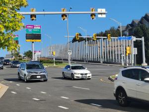
Today, the vast majority of people traveling to, from, around and through Tysons do so using private automobiles. However the projected growth of Tysons as a residential and employment center means we have to accept the urban center that Tysons has become – and plan for a transportation network that will get people to work, home, school, shopping, errands, entertainment and more. 

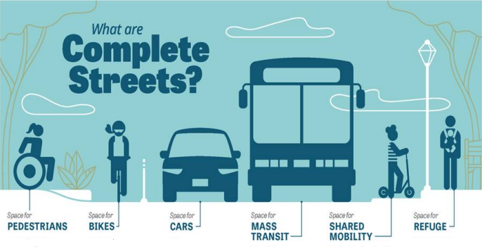
As we watch Tysons grow up (literally), we must acknowledge and accept that moving residents and commuters solely in cars will be impossible. There simply isn’t enough space and roads to accommodate the surging population. We must commit to other forms of transportation to keep people moving: transit, ridesharing, and active transportation options like bicycles, scooters and walking must be part of the mix.

Using the Fairfax County Comprehensive Plan as a guide, we will help Tysons shed its automobile past and become the future of urban living in Fairfax County, offering safe and accessible transportation that balances the needs of transit users, bicyclists, pedestrians and drivers.

Metrorail Silver Line Extension

Metro Silver Line Extension
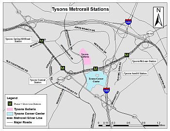
In 2014, four Metrorail Silver Line Stations opened in Tysons. These rail stations carry the majority of transit trips to, from and through Tysons. In late 2022, the Silver Line Phase II will be complete. Six new stations will operate beyond Tysons; Reston Town Center, Herndon, Innovation Center, Dulles Airport, Loudoun Gateway, Ashburn. More detailed information can be found at the Dulles Metrorail Project website or Metro's Silver Line Extension webpage. In Tysons, the station names and cross-streets where they are located are as follows:

  • McLean - Located on Route 123 at Scotts Crossing Road
  • Tysons - Located on Route 123 at Tysons Boulevard
  • Greensboro - Located on Route 7 northwest of Route 123
  • Spring Hill - Located on Route 7 at Spring Hill Road

Express and Local Bus Service to Tysons

OPENED JANUARY 2023: New Fairfax Connector route along I-66 express lanes between Tysons-Centreville

Fairfax Connector Bus Network (Tysons) Connector Logo
401: Backlick - Gallows Northbound
402: Backlick - Gallows Southbound
432: Old Courthouse - Beulah
462: Dunn Loring - Navy Federal - Tysons
463: Maple Avenue - Tysons
467: Dunn Loring - Vienna Community Center - Vienna Town Hall - Tysons
494: Springfield - Tysons
495: Burke Centre VRE - Tysons
574: Reston Town Center - Tysons
721: Chain Bridge Road - McLean
724: Lewinsville Road
Tysons Circulator
423: Central Tysons - Tysons Metro
424: North Tysons - Spring Hill Metro
Metrobus Route
28A: King Street Old Town - Tysons Metro

Grid of Streets

Tysons Grid of Streets

Tysons Grid of Streets (2022) A grid of streets with smaller block sizes is typical in urban areas. It disperses vehicle traffic and improves mobility for pedestrians and bicyclists by providing short, direct connections between multiple points in an area. Smaller block sizes will make Tysons more walkable by creating convenient and short walk distances between points in Tysons and will improve pedestrian and bicycle access to the four Silver Line Metrorail Stations in Tysons.

Complete Streets with Pedestrian and Bicycle Facilities

complete streets

The Comprehensive Plan calls for "Compete Streets" in Tysons Corner; a mixed-use urban center with a more traditional downtown feel.

By definition, complete streets are designed and operated to enable safe access and movement for pedestrians, bicyclists, motorists and transit riders of all ages and abilities. Complete streets in Tysons are attractive environments that include; sidewalks buffered from traffic by street trees, and bicycle enhancements, such as separate bike lanes, to address the elements of a complete street.

Additional Information

The Comprehensive Plan for the Tysons Corner Urban Center calls for the establishment of a Tysons Corner Transportation Management Association to develop and promote Transportation Demand Management (TDM) programs to stakeholders, major employers and developers in Tysons Corner. TDM refers to a variety of strategies aimed at reducing the demand on the transportation system, particularly to reducing single occupant vehicles during peak periods, and expanding the transportation choices available to residents, employees, shoppers and visitors. The result is a more efficient use of the existing transportation system.

When the four Metrorail stations open in Tysons and denser mixed use transit-oriented development is constructed surrounding the stations, a substantial percentage of travelers are expected to commute via Metrorail without any TDM programs in place. This development pattern will also reduce the need for driving trips because jobs, housing, shopping, recreational and cultural opportunities will be close at hand and accessible by walking or a short transit ride. A broad, systematic, and integrated program of TDM strategies throughout Tysons can further reduce peak period single occupancy vehicle trips, as well as increase the percentage of travelers using transit and non-vehicular modes of transportation. Examples of TDM Measures include:

  • Transit and vanpool subsidies
  • Pre-tax deduction of transit and vanpool fares
  • Telework program
  • Carpool and vanpool matching service
  • Shower and locker facilities for bicyclists and walkers
  • Secure and weatherproof bicycle parking
  • Carpool and vanpool preferential parking
  • On-site car-sharing vehicle
  • Employee shuttle
  • Guaranteed Ride Home Program
  • Commuter information center (bulletin board, web site, brochure table)
  • Employee Transportation Coordinator (ETC)
  • Flexible or alternative work hours
  • TDM education programs directed at the public and employers


In order to maintain an acceptable level of accessibility in and around Tysons Corner as development occurs over time, it is essential to keep a balance between land use and transportation. To maintain this balance, the increase in development in Tysons should be coordinated with the provision of transportation infrastructure and programs to reduce vehicular trips. Considerable analysis was conducted to determine the need for specific transportation programs and infrastructure for a specific level of development in Tysons. From the results of this analysis, the following strategies were identified that need to be successfully implemented to maintain a balance between land use and transportation:

  1. The phased provision of transportation infrastructure, as detailed in Table 7 in the Comprehensive Plan. Major components of transportation infrastructure are the grid of streets, new transit routes, and new connections in and out of Tysons.
     
  2. The achievement of vehicle trip reduction levels, as specified in Table 5 in the Comprehensive Plan. Essential in obtaining these vehicle trip reductions are the following:
    • TDM programs, as specified in the TDM section of the Plan.
    • Achievement of transit modal split levels, specified in Table 2 of the Comprehensive Plan.
    • Limitations to the provision of parking, specified in Table 6 of the Comprehensive Plan.
    • Increasing the amount of residential development in Tysons as specified in the Land Use section of the Plan.
    • Excellence in urban design, successful integration with Metro stations, and the achievement of the mix of uses and the facilities which creates the largest possible internal trip capture.
  3. A monitoring system, described in the "Monitoring System" section of the plan, to verify that strategies 1 and 2 are realized as planned, and to apply timely adjustments if there are variations from the recommendations on how a balance will be maintained.
Fairfax Virtual Assistant