Public Works and Environmental Services

CONTACT INFORMATION: Our administrative offices are open 8 a.m. – 4:30 p.m., Mon - Fri
703-324-5500 TTY 711
12000 Government Center Parkway
Suite 449, Fairfax, Va 22035
Shannon Curtis
Chief, Watershed Assessment Branch

Difficult Run Watershed

map of area watershedLocation
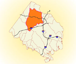
Difficult Run is a 57.7-square-mile watershed in the north-central portion of Fairfax County and drains directly to the Potomac River.

Major Streams and Tributaries
Captain Hickory Run, Piney Run, Colvin Run, Snakeden Branch, Little Difficult Run, Rocky Run, Angelico Branch, Piney Branch, Wolftrap Creek and Rocky Run

Unique Features
This watershed is home to Wolf Trap Farm Park and part of Great Falls Park. It is crossed by several major highways, including Leesburg Pike, I-66, Route 50, and the Dulles Access Road, and by the W&OD Trail. It contains four manmade lakes: Lake Anne and Lake Fairfax on Colvin Run, and Lake Thoreau and Lake Audubon on Snakeden Branch. Difficult Run flows through a wide variety of watershed conditions, from forest to urban areas. Just before its empties into the Potomac River, it flows through a narrow, cliff-lined valley. Difficult Run is the largest watershed in Fairfax County.

Improvement Opportunities
The plans identify areas of opportunity for implementing both structural and non-structural improvement projects such as stream restorations, stormwater facility retrofits, community education and stewardship, streamside buffer enhancements and installation of green stormwater infrastructure (GSI). Proposed projects in the plans have recommended priorities. These lists should not be interpreted as specific implementation schedules or a guarantee that the project will be implemented through the planned Capital Improvement Program (CIP). A full list of active or completed Stormwater projects is available online on at Stormwater Improvement Projects or through Jade (Fairfax County's Comprehensive Mapping Application).

Fairfax Virtual Assistant