Public Works and Environmental Services

CONTACT INFORMATION: Our offices are open to the public by appointment only at this time. Please call or email 8 a.m. - 4:30 p.m., Monday - Friday
703-324-5033 TTY 711
12000 Government Center Parkway
Suite 448 Fairfax, VA 22035
Christopher S. Herrington
Director

Watershed Monitoring

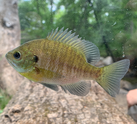
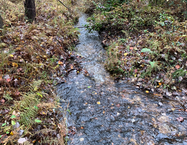
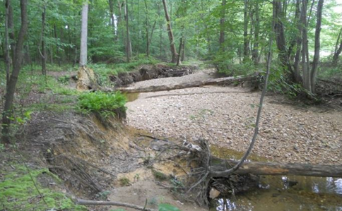
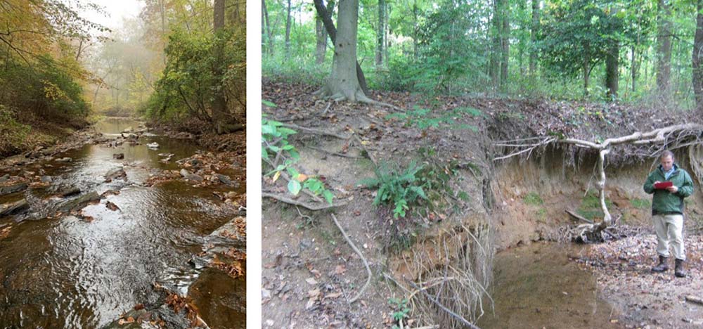
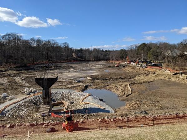
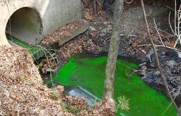
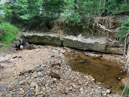
Clean water is important for healthy ecosystems and a sustainable environment. Human actions impact the County’s streams, lakes, wetlands, rivers, and the lands that drain them. These are called watersheds.

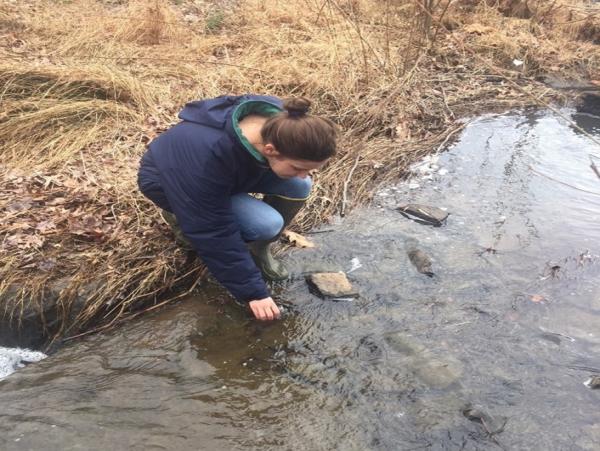
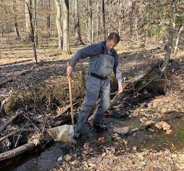
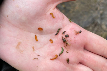
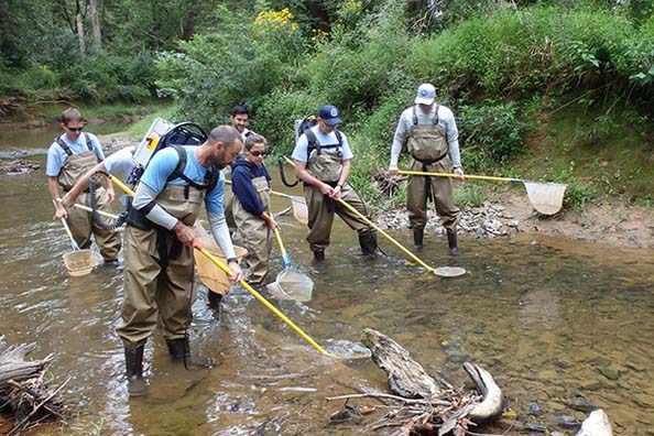
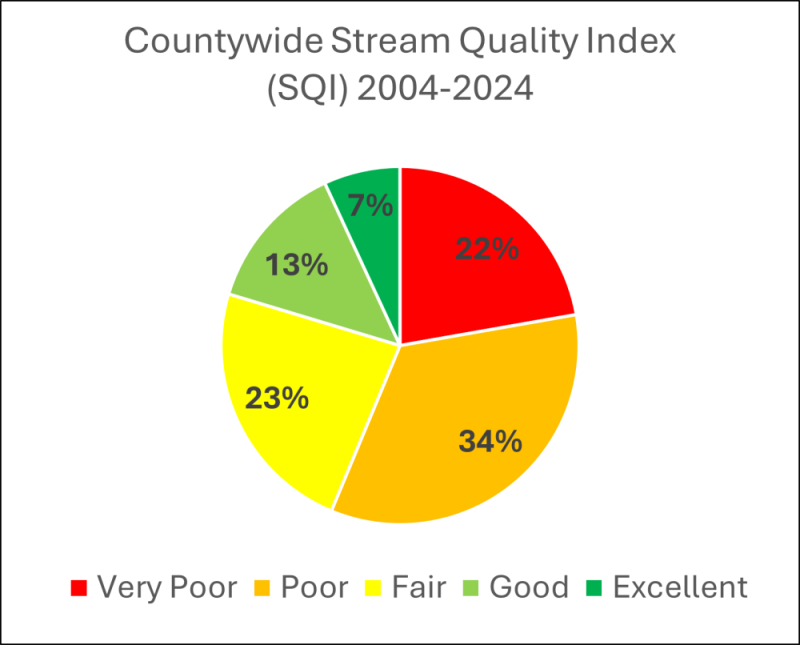
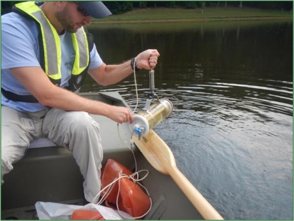
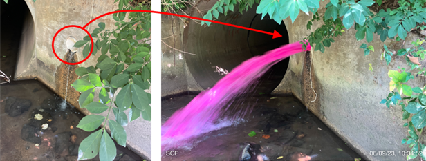
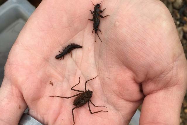
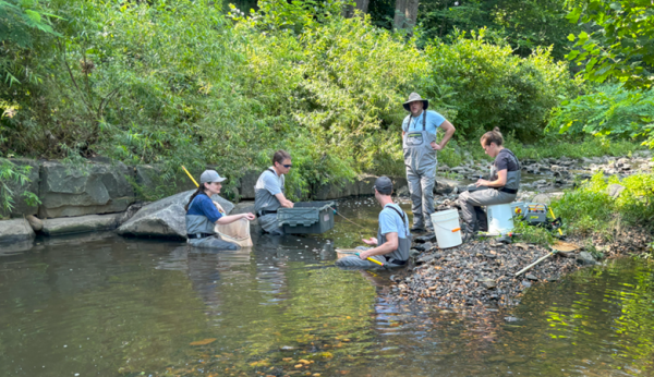
Fairfax County studies stream health by monitoring living and non-living parts of our freshwater ecosystems. This information helps assess the condition of our watersheds and guides efforts to protect and care for our local freshwater resources. Environmental monitoring of our watersheds is required by state and federal laws and supports Fairfax County’s environmental goals.

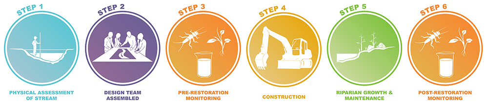
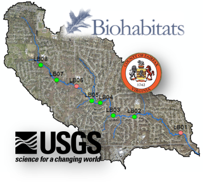
Learn more about how Fairfax County measures the health of our streams and lakes.

On This Page

Bacteria and Nutrient Monitoring

Bacteria & Nutrient Monitoring

Each year, Fairfax County staff take water samples from 40 different streams. They do this to check if there are pollution problems in the water. They look for a type of bacteria called E. coli which shows that human or animal waste may have gotten into the water.

The county Health Department does not recommend swimming in natural waters like streams, rivers, and ponds.

Bacteria monitoring helps identify issues like broken wastewater pipes or other pollution sources. The amount of E. coli in the water is compared to the safe limit. The safe limit is 235 cfu/100 ml based on Virginia's standards. If the amount found is too high, the County will collect more samples to find the source of the problem.

County staff collects a water sample
County staff collects a water sample from a stream to be tested for E. coli., nitrogen and phosphorus.

In 2019, a stream was found to have very high E. coli levels (48,000 cfu/100 ml), which is more than 200 times the state limit. County staff traced the problem to a broken sewer pipe caused by a tree falling on it. This pipe was leaking wastewater into the stream. The county repaired the broken sewer pipe quickly and stopped more pollution from getting into the stream.

Emergency construction to repair a broken sanitary sewer line
Emergency construction to repair a broken sanitary sewer line detected by the bacteria monitoring program.

The county tests water samples for nutrients (nitrogen and phosphorus) at the same locations as bacteria monitoring. High levels of nutrients can indicate possible stream contamination from wastewater sources. Too much nitrogen and phosphorus in streams can lead to poor water quality and algae blooms. It can also harm fish and other animals living in the water. Reducing these nutrients helps to protect local streams, the Potomac River, and the Chesapeake Bay.

Biological Monitoring

Biological Monitoring

Fairfax County staff study two main groups of freshwater organisms. These are critters like benthic macroinvertebrates and fish. Benthic macroinvertebrates are small aquatic animals such as insects, snails, worms, clams, and small crustaceans. They are bottom-dwelling (benthic), are visible without magnification (macro) and lack a backbone (invertebrate). Benthic macroinvertebrates are often found attached to rocks, vegetation, logs and sticks. They may also be found burrowed into sand and sediments in streams, rivers, lakes, and ponds.

These organisms are important because they spend all or most of their lives in water. They respond differently to pollution and other changes in their environment. This makes them very good indicators of overall stream health. By studying freshwater organisms, the County can learn whether the water is clean or polluted. They may be able to spot problems that might not show up in other water quality tests. These assessments are especially helpful in understanding how things like urban growth, stormwater systems, and other human activities affect our watersheds. The County uses this information to plan and manage resources, and to protect and restore the environment.

County staff monitoring stream benthic macroinvertebrates.

County staff monitor benthic macroinvertebrates in both spring and fall. Each stream location is given a score based on several factors. These factors include the variety of organisms, the number found, and how sensitive they are to pollution. This score is called the Index of Biological Integrity (IBI). These individual scores are then combined to create a bigger picture of stream health for the whole County, called the Stream Quality Index (SQI). The IBI scores are also reported to the state and used to evaluate stream restoration projects.

Examples of benthic macroinvertebrates
Examples of benthic macroinvertebrates found in streams.

Fairfax County monitors fish communities between June and September. Freshwater fishes are another group of indicators of stream health. Fish are important to residents as a recreational resource and are connected to the County’s natural heritage. The presence of fish helps indicate the health of the entire stream. This is because fish are higher in the food chain, are longer-lived, and are more mobile than invertebrates. Learn more about the different fish found in Fairfax County by visiting Fishes of Fairfax.

County staff sampling  the fish community.
County staff sampling the fish community.
 
Example of fish found in streams
Example of fish found in streams (Bluegill, L. macrochirus).
Countywide Stream Monitoring

Countywide Stream Monitoring

Fairfax County collects freshwater invertebrates at many stream locations across the county each year. Some of these organisms can only live in clean water, while others are able to survive in polluted conditions. Based on the types of invertebrates found, each location receives a rating of excellent, good, fair, poor or very poor. About 80 percent of these locations receive grades of fair, poor or very poor. This indicates that most county streams are not very healthy. They have likely been affected by polluted runoff, erosion, and sediment from human activities on the landscape.

Countywide Stream Quality Index (SQI) 2004-2024
Chart of all SQI scores from 2004 through 2024.

Each year, 40 stream monitoring sites across the county are randomly selected based upon the size and location of the streams. Random sampling helps the county understand both the health of each selected stream and the overall health of all county streams. This sampling design is a statistically valid approach, called “Probabilistic Monitoring”. At each selected location, the amount of bacteria in the water is measured along with assessments of freshwater invertebrates, fish, and stream habitat. Water properties such as temperature, conductivity pH, and dissolved oxygen, as well as the nitrogen and phosphorus are also measured at these locations.

Stream ratings from all sites are combined to produce an overall countywide rating each year called the Stream Quality Index (SQI). Higher SQIs indicate better stream health. Yearly results of this index can be found in the SQI table.

The methods used to survey freshwater invertebrates, fish, and stream features (habitat) follow guidelines adapted from the US Environmental Protection Agency (EPA). These methods are detailed in the county's Standard Operating Procedures Manual for the Fairfax County Biological Stream Monitoring Program. See the EPA’s Rapid Bioassessment Protocol (RBP) for streams and small rivers for more information.

Habitat and Physical Assessment

Habitat and Physical Assessment

As we develop our land, too much runoff flows to our streams quickly instead of soaking into the ground. This causes our streams to erode. As stream channels shift, aquatic habitats are damaged or buried which harms our wildlife. Severe streambank erosion can negatively affect nearby properties and the Chesapeake Bay. Fairfax County’s Capital Improvement Program (CIP) provides funds for projects that halt erosion and improve the habitat of poor-quality streams.

Every year, Fairfax County staff check the condition of select streams around the County. They focus on the stream’s habitat, physical features, and the land around it.

Rapid Habitat Assessments are based on EPA protocols.

These assessments focus on the stream’s ability to support aquatic life. Both the in-stream and nearby land habitats are evaluated, since they affect the health and variety of life in the water. Ten different habitat categories like erosion, sedimentation, and nearby vegetation, are scored. This habitat assessment is used in several other monitoring programs. These programs include Countywide Stream Monitoring, the Water Resources Monitoring Network-(Fairfax-USGS Partnership), and Permit Required Monitoring.

high-quality habitat
Photo above shows excellent stability and vegetation along the stream bank. This is a stable, high-quality habitat feature.
low-quality habitat
Photo shows excess sediment within the stream channel. This is low-quality habitat in streams.

County staff perform visual stream physical assessments in the winter and early spring to assess current stream conditions. They look at the stream’s physical condition, locate stable areas, and identify spots where the stream might need improvement. Staff walk along streams and assess 20 different features. Some of these features are bank stability, erosion, and sedimentation. Only a portion of the county is assessed each year.

good and poor quality streams
A good quality, stable stream (left) and a poor quality, unstable stream (right) as assessed by the SPA.


Please see the Stream Physical Assessment Map for the area of the county that has been assessed.

Uses for the stream physical assessment results

  • Identify locations of instability for inclusion in the County’s CIP project process
  • Identify damaged, deficient, or at-risk stormwater, wastewater, or other types of infrastructure
  • Identify stream corridors in stable physical condition
  • Watershed management planning
Lakes Monitoring

Lakes Monitoring

Fairfax County staff monitor the water quality of four lakes in the Pohick Creek watershed. The lakes were constructed in the 1970s and 1980s to manage excess runoff and trap sediment caused by development in the watershed.

The purpose of the lakes program is to monitor and analyze lake water nutrients, sediment, and chemistry. Chemistry includes temperature, pH, specific conductance, and dissolved oxygen. This will better inform management of these facilities.

Through this program, the County learned that these lakes stratify, or separate into layers, during the summer months. Layering occurred at depths between one and two meters. This resulted in low dissolved oxygen (DO) at the bottom of the lake and high DO at the top. This information is helpful for effective natural resource management. It shows that fish and invertebrates, which need oxygen to live, cannot survive in deep water during the summer.

County staff collecting a deep-water sample.

One way the County manages these lakes is by removing sediment from the lake bottom by dredging. All four lakes have been drained and dredged since 2014. The purpose is to increase sediment storage, improve water quality both within and downstream of the lake, and create easier access for future maintenance. Results show that after dredging, water quality improved with significant reductions in nitrogen, phosphorus, and total suspended solids (TSS). However, each year following the dredge, these concentrations began to increase again.

When the lakes were drained, each lake outlet was re-designed to allow both surface water and deep water to flow from the lake. The lake outlet is called a riser. This helped reduce the temperature by 2 degrees Celsius downstream of the lakes in the summer, which benefits the stream organisms.

Lake Barton drained during dredging
Lake Barton drained during dredging in 2020-2021. The riser structure is in the foreground.
 

Permit Required Monitoring

Permit Required Monitoring

Fairfax County has a state-issued stormwater permit called the Municipal Separate Storm Sewer System (MS4) Permit. This permit requires the county to keep harmful pollution from draining into local streams and rivers. Examples include engine oil, fertilizer, pet waste, pool water, and trash. Material that enters the county’s MS4 does not go to a wastewater treatment plant and instead goes to county streams. The permit requires the County to regularly check the condition of streams and the stormwater system. By tracking pollution and stream health, Fairfax County ensures its stormwater system works properly and protects the local environment. These efforts directly contribute to cleaner water for the community and the natural world around it.

During dry weather periods, county staff monitor places where stormwater flows out of the storm sewer system and into streams. They check to see if pollution gets into these pipes when it’s not raining. This helps the County detect problems like broken sewer or drinking water pipes, illegal wastewater connections, car wash runoff, or pool water getting into the stormwater system. Staff check more than 100 of these "outfalls" each year. Identifying and fixing these issues helps keep the streams healthier.

County staff used a pink dye tracer to find an improper connection to a county stream.
County staff used green dye tracer to find the source of pollution entering the county storm sewer network.
County staff used green dye to detect an improper wastewater connection to the storm sewer network.

When it rains, stormwater runoff from industrial and commercial areas can carry more pollution into streams than other parts of the County. Some common examples are car repair shops or shopping malls. To track this, the county monitors water running off the land in these areas during rainstorms through MS4 outfalls. This helps them estimate how much pollution is entering the streams and which areas are causing the most pollution. Unlike dry weather screening, this work focuses on the pollution carried by rainwater.

Twice a year, in spring and fall, county staff check five stream locations to see how healthy they are by looking at benthic macroinvertebrates. They are insects, crayfish and other organisms that live in the bottoms of streams. These small animals are great indicators of stream health because they each have different sensitivities to pollution and other changes to their environment. The county studies what kinds and how many organisms are present in the stream. This helps us understand how clean or polluted the water is and how well streams are doing overall. Stream habitat is also evaluated during these surveys.

Examples of benthic macroinvertebrates found in streams.

The county is also required to collect and test stream water at the same five locations used for biological monitoring. Fairfax County collects water samples six times a year.  The focus is on harmful bacteria (E. coli), nutrients like nitrogen and phosphorus, temperature, pH, dissolved oxygen, and cloudy water caused by suspended solids. These tests help track ongoing stream conditions and identify any problem areas.

Each year, the County reports all their findings from these monitoring efforts to the Virginia Department of Environmental Quality (DEQ). The latest reports can be found in the MS4 Program Plan and Annual Reports.

You can report polluted run-off due to improper or illicit dumping of materials into the county’s streams or storm sewer system. Visit Pollution Runoff Inspection to learn more and submit a report.

Restoration Monitoring

Restoration Monitoring

Fairfax County invests over 25 percent of the stormwater annual budget on watershed improvement projects. These include stream restorations, outfall improvements, and stormwater pond retrofits. These projects help to prevent erosion in local streams, and reduce nitrogen, phosphorus, and sediment pollution from getting to the Chesapeake Bay.

Residents, managers and elected officials want to know how effective these restoration activities are at improving water quality and ecological function. To evaluate these projects, a stream restoration monitoring framework was implemented.

Stream Monitoring Frameword
Stream monitoring framework steps: Physical Assessment of Stream, Design Team Assembled, Pre-restoration Monitoring, Construction, Riparian Growth & Maintenance, Post-restoration Monitoring,

Monitoring occurs for at least 2 years before construction, allows 2 years for plant growth after construction is complete, then another 2 times after the plants are established.

Approximately 10 restoration sites are monitored each year for stream invertebrates and water chemistry. However, new monitoring may be added, based upon the goals of specific projects. The goal of stream restoration monitoring is to determine what practices give the best water quality and ecological benefits. This information can be replicated to better improve stream restorations throughout the county and the Chesapeake Bay watershed.

County staff identify fish in a Scotts Run stream restoration project.


The county, together with the U.S. Geological Survey (USGS) and BioHabitats, Inc., is working on a study. There are 18 water quality projects in the Long Branch Central Watershed. They will study how these projects improve the health of the streams and overall watershed. This study has a broad scope, involving both yearly and continuous monitoring of the watershed. Additional monitoring will occur at many individual stream restoration projects. Learn more about the Fairfax County - USGS Partnership: Water Resources Monitoring Network.

The team will monitor things like water flow in the channel and on floodplains, erosion, the shape of the streams, groundwater levels, and water quality. They also monitor the plants and animals living there. This data will be collected before, during, and after the projects are complete. Find out more at Long Branch Central Watershed Management Area Project.

Bank erosion, an exposed sanitary sewer line, and excess sediment deposited in the stream channel in the Long Branch Central Watershed.
Fairfax-USGS Monitoring locations
Long Branch Central Watershed and some of the monitoring locations. Pink dots have USGS continuous monitoring gages, and green dots have annual erosion and ground water monitoring.
 
Water Resources Monitoring Network
Fairfax Virtual Assistant