Transportation Alert:
In September 2025, FCDOT decided to separate the project into two phases:
The following materials are now available:
Uploaded August 3, 2021:
Other helpful links:
The Fairfax County Department of Transportation held a virtual meeting on the Cinder Bed Road Bikeway project on Monday, May 10, 2021, at 7 p.m.
Comments were due Monday, May 24, 2021. Please contact the project team through:
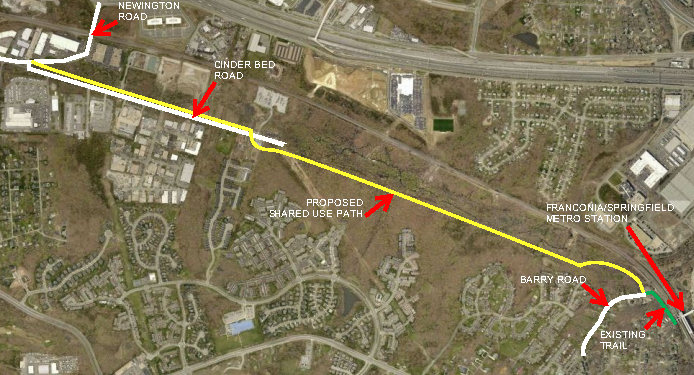
The Cinder Bed Road Bikeway project will provide a continuous shared use path between Newington Road and the Franconia-Springfield Metro Station. A shared use path will be constructed along the west side of Cinder Bed Road, connect to an existing trail through Fairfax County Park Authority (FCPA) property, and then continue through private property to tie into the trail at the end of Barry Road that leads to the Franconia/Springfield Metro Station. Two pedestrian bridges will be constructed to cross Long Branch. The project length is approximately two miles.
Project Exhibits:
The project is funded with County funds along with Federal Transportation Alternatives Program (TAP) Grant funds.
Fairfax County Project Number – 1400137-15
State Project Numbers – EN14-029-107, P101, R201, UPC #106143
FCDOT ensures nondiscrimination in all programs and activities in accordance with Title VI of the Civil Rights Act of 1964 and the Americans with Disabilities Act (ADA). If you need this information in an alternate format or would like to request reasonable accommodations for persons with disabilities or limited English proficiency, contact FCDOT at 703-877-5600, TTY 711. Requests for assistance must be received at least 7 business days in advance of an event.
Questions/Comments:
Answer/Explanation:
The Cinder Bed Road Bikeway Trail has been a part of the Fairfax County Bicycle Master Plan since the 1980s, included in the Countywide Trails Plan for many years, and was approved by the Board of Supervisors in 2014. The Bikeway provides key community benefits that cannot be replicated by using right-of-way on existing roads, including:
The Fairfax County Department of Transportation (FCDOT) has worked extensively with the community in developing a trail design that maximizes these benefits while minimizing environmental risks. The trail's current design avoids the most environmentally sensitive areas, providing residents with safe and comfortable access to green space while ensuring that local plant and animal life will still be able to thrive.
Question:
What public outreach efforts have been made on the project?
Answer:
The first public meeting on the project was held in May 2021. Since then, Supervisor Lusk's office and FCDOT have met several times over the years with environmental advocates as well as homeowner associations, holding multiple walkthroughs of the project site. FCDOT has answered many questions in detail, performed significant additional analysis in partnership with environmental experts, and made several changes to the project design to mitigate impacts significantly.
Environmental groups including Nature Forward, Friends of Accotink Creek, the Northern Virginia Bird Alliance and the Sierra Club have been invested partners throughout the project. These groups, among others, have recently advocated for proposed language in the Active Transportation and Trails Plan Map, for trails through open space or in stream valley, that says, “Additional environmental and cultural resource review should occur prior to finalizing design”. Supervisor Lusk supported this amendment, and the language was passed by the Board of Supervisors on May 5, 2026.
Question/Concern:
It is wrong to intrude into streamside Resource Protection Areas while citizens are fined for doing so.
Answer/Explanation:
The proposed Project meets the provisions of the Fairfax County Chesapeake Bay Preservation Ordinance (CBPO) Section 118-5-2, which states public facilities are an allowed use within Resource Protection Areas (RPAs). To comply with the Chesapeake Bay Preservation Area Designation and Management Regulations and the Fairfax County CBPO, the Project was submitted for review to Fairfax County Department of Public Works and Environmental Services (DPWES), requesting their approval to qualify for an exemption to the CBPO. Efforts have been made to minimize the limits of disturbance in the RPA. The County is providing and will adhere to a landscaping plan to revegetate the impacted RPAs with native tree species after construction.
Question/Concern:
It is wrong to contribute to stormwater runoff while citizens are taxed millions for stream restoration
Answer/Explanation:
The project is required to comply with all applicable federal regulations, standards and requirements. The Fairfax County Stormwater Management Ordinance, and the Virginia Department of Environmental Quality-Virginia Stormwater Management Program (DEQ VSMP) regulations have been used for compliance with water quality and quantity analysis. The Virginia Runoff Reduction Method (VRRM) was utilized to determine the pollutant removal requirements. Offsite nutrient credits, within the same watershed, will be purchased to satisfy water quality requirements.
Questions/Concerns:
Answer/Explanation:
Delineation of jurisdictional waters, including wetlands, within the project study area has been conducted in support of the proposed Cinder Bed Road Bikeway Project. The Project study area is located east of I-95 between Cinder Bed Road at Newington Road and the end of Barry Road near the Franconia-Springfield Metrorail Station, and the existing Metro Path.
The study area includes portions of existing public right-of-way adjacent to Cinder Bed Road and along the existing trail facility, within Fairfax Enclave at Long Branch development, and a portion of forested floodplain, where the Project would be constructed on new location.
Preliminary Jurisdictional Determination (PJD) NAO-2020-00461 was issued by the U.S. Army Corps of Engineers (USACE) on April 7, 2020. Since the PJD was issued over five years ago, the entire Project study area was re-delineated in July and August 2025 to ensure jurisdictional feature boundaries are accurate. There are additional areas included in the delineation due to design changes. The report of the re-delineation was completed in October 2025, and it will be included in the Joint Permit Application (JPA) submittal to the U.S. Army Corps of Engineers (USACE) and the Virginia Department of Environmental Quality (VDEQ), requesting authorization for impacts to Waters of the U.S. for the construction of the project.
Most recently, a field visit was conducted on September 3, 2025, to evaluate the Coastal Plain/Outer Piedmont Acidic Seepage Swamp within the Newington Conservation Area. Representatives from Virginia Department of Conservation and Recreation (DCR), FCDOT, the project design consultant and environmental specialist, Whitman, Requardt & Associates, LLP (WRA), and Friends of Accotink were in attendance. During the site visit both the old (2020) acidic seepage swamp and new (2023) northern polygon were visited. The group walked the proposed trail alignment, which bisects the new DCR acidic seepage swamp polygon.
During the visit, DCR took photos and field notes with intended coordination with DCR staff to potentially change and reduce the limits of this natural heritage resource based on field observations. WRA explained the avoidance and minimization measures in place to allow groundwater to flow beneath the trail and maintain the hydrology of the area.
DCR ultimately reduced the limits of the significant natural communities and revealed that the Cinder Bed Bikeway trail alignment was nearly entirely out of the path of these communities. This was a significant finding and that the project will have less environmental impact than originally estimated.
The Cinder Bed Road Bikeway project has been split into two phases. Phase 1 – from Newington Road to Cinder Bed Road cul-de-sac, and Phase 2 – from Cinder Bed Road cul-de-sac to Barry Road, including two pedestrian bridges. JPA for the Cinder Bed Road Bikeway Phase 1 has been submitted to USACE and DEQ and the review is in progress. JPA submittal for Phase 2 will be made once the project progresses to Final design. The approved NEPA document will be submitted for re-evaluation to Virginia Department of Transportation before construction commences.
Multiple design considerations have been implemented to minimize environmental impacts within the Phase 2 limit of the project, which include: