

Lots that were created before the zoning ordinance was enacted or were created by recordation of a plat or deed without county approval may be “validated” by the county. If the legality of a lot is unclear, a lot validation can determine whether the lot meets certain requirements and can be validated so that a building permit may potentially be issued for the development of that lot. County Code Sections 101-1-12, 101-1-13, and 101-1-14 describe the process for validating a lot. Once the review is complete, the county will issue a written determination as to whether a land parcel is a valid lot or unbuildable outlot.
A “valid” lot may not be a “buildable” lot. For a lot to be “buildable”, it must meet the minimum yard and floodplain requirements of the Fairfax County Zoning Ordinance, the requirements of the Chesapeake Bay Preservation Ordinance, and the appropriate erosion and sedimentation and stormwater measures. In addition, the lot must have legal access from a public road and all necessary well and septic permits must be obtained.
Before proceeding with a Lot Validation request, please consider the following:
- Per Zoning Ordinance 112.1.5100.2J, any lot recorded before March 1, 1941 is a valid lot and does not require a formal Lot Validation submission.
- If your lot was created between March 1, 1941 and March 25, 2003, it is a valid lot if it is identified as a separate lot on the Fairfax County Real Property Identification Map and contained a principal structure on March 9, 2004 and therefore does not require a formal Lot Validation submission.
- If your lot has red property boundary lines as shown on the Digital Map Viewer, this is an indication that the property was split but did not go through the subdivision control process. Verification of property lines may be accomplished by a licensed land surveyor or by submitting a Lot Validation request to the county.
Additionally, as of 2018, the Department of Tax Administration (DTA) no longer considers lot consolidations for administrative tax purposes. All previously consolidated tax map numbers created to receive one tax bill have been grandfathered. Property owners wishing to consolidate multiple parcels must record a deed of consolidation with Fairfax County Land Records. For more information, please contact @DTA RED or visit DTA’s website.
ON THIS PAGE
This information is the most common for how to obtain the necessary approval for your project and is not representative of all the conditions you may encounter.
WHO SHOULD APPLY?
Property owners or their duly authorized agents may submit lot validation applications.
PLAN AHEAD
Before submitting, ensure you are aware of all applicable regulations and conditions that could affect your project to avoid surprises during the review process. Some of those factors include:
- Zoning Information
- Design Codes and Standards
- Do I Need to Hire a Design Professional?
- Floodplains
- Resource Protection Areas (RPA)
- Grading/Site Plans
- Parking Tabulation
- Types of Soils and Problem Soils
- Researching Site Conditions
To get a detailed description about each regulation and condition, visit our Plan Ahead page.
HOW DO I SUBMIT MY RECORD?
PLUS Application
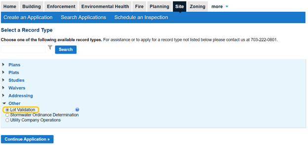
Apply for your lot validation online in PLUS under the Site tab. If you are a first-time user, you must first register for an account.
Tutorial on Uploading Plans and Documents in PLUS
Requirements
To complete the Lot Validation Request you will need to first obtain the following information about the lot or lots that you are requesting be validated:
- Property address
- Tax map and parcel number
- Current zoning district designation
- Magisterial (supervisor) district where the lot is located
- Subdivision name (if within an existing subdivision)
- The deed book and page number (if known) where the document that created the lot is filed among the county land records
- Review fee
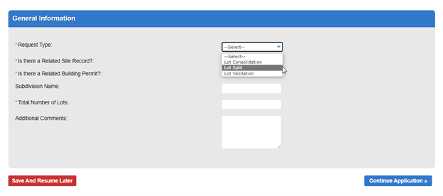
To submit a lot split request, select the “lot split” Request Type option under General Information in PLUS and complete the Owner Request to Split Tax Map Numbers form.
What's Next?
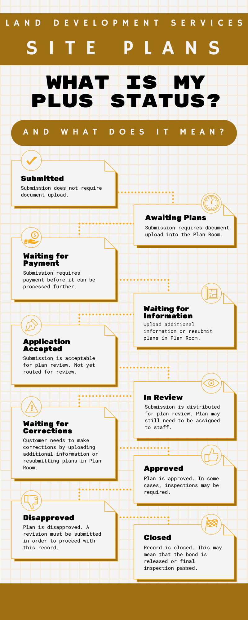
To get a step-by-step guide on PLUS statuses and what they mean, see our What is My PLUS Status? Site Plans Infographic.
Review Process
Staff from the Site Application Center and Site Development and Inspections Division will review your package for completeness and compliance with submission requirements. Lot Validations are also reviewed by the County Surveyor’s Office, and the Department of Planning and Development. Once the review is complete, staff will issue a determination as to whether the requested lot is a validated lot (e.g., a building permit may be issued for work on the lot) or an outlot (no building permit may be issued on the lot).
Issuance of Determination
Once all reviews are approved and fees have been paid, your lot validation determination will be available to download from PLUS.
Helpful Video:
![]() Approved Plans - YouTube Video
Approved Plans - YouTube Video
