Headwaters of Popes Head Creek at Brecon Ridge Subdivision Stream Restoration Project
Project Number: SD-000031-220 (PH9271/PH9272)
Project Update: March 27, 2024
Design is currently on hold until easements are acquired.
Popes Head at Brecon Ridge Stream Restoration Story Map
The Popes Head Creek at Brecon Ridge project will restore approximately 5,300 linear feet of Popes Head Creek including a short section of one tributary, stabilize stormwater outfalls, and re-establish the stream valley floodplain connection and riparian corridor.
The Popes Head Creek Watershed Management Plan identifies this project for stream restoration and stabilization as PH9271 and PH9272. In September 2019, Stormwater Planning Division staff initiated the project design.
Project Description
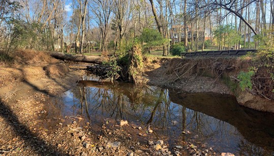
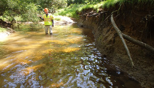
The project will restore approximately 3,000 linear feet of Popes Head Creek, stabilize stormwater outfalls, and re-establish the stream valley floodplain connection and riparian corridor. Over this reach, the stream is severely eroded, down cut, incised and overly widened.
Without the restoration project, a great potential exists that stream bed and bank instability will continue eroding and damaging privately-owned and homeowners’ association-owned property while continuing to further impair water quality in Popes Head Creek.
The goal is to implement a sustainable project to protect property, health, and safety while improving water quality. This will be accomplished by restoring the stream’s dimension, pattern, and profile to a form appropriate for current and future watershed conditions. The project will also restore equilibrium to the channel and riparian corridor supporting effective conveyance of water and sediment without excessive channel erosion and migration. The design will enhance the natural habitat supporting improved biodiversity and restoring channel and floodplain ability to naturally process excess nutrients and sediment. Protecting and preserving existing trees to the greatest extent possible is always a priority. The work will repurpose, and use removed trees and existing streambed material within the project reach to the greatest extent possible.
The project is part of Fairfax County’s larger efforts to restore degraded streams while improving overall water quality in local waterways and the Chesapeake Bay.
The primary restoration objectives are:
Improve water quality by stabilizing the continuously eroding bed and banks
Naturally process nutrients and sediment on the floodplain
Provide groundwater recharge for the local aquifer
Enhance riparian forest habitat by planting native trees, shrubs, and herbaceous plants
Restore the ecological function of the stream and the riparian zone to process phosphorous, nitrogen, and sediment
Restore and enhance the aquatic and riparian habitats
Coordinate closely with community stakeholders to support project goals and commitment to future efforts to help maintain success
Project Location
The project begins on the south side of Braddock Road approximately 725 linear feet east of the Bellmont Drive intersection extending approximately 3,000 linear feet south.
Project benefits include improving water quality and protecting property, health, and safety.
Providing a stable stream channel and alignment will protect property by reducing the severe soil erosion of the bed and banks leading to channel migration
Health and safety will be protected by removing trees at risk of falling and, where possible, completing work to support improved tree health
Improving water quality will be achieved through natural ecosystem cycling and removing inputs that increase nitrogen, phosphorus, and total suspended solids (aka sediment) pollutants
Removing non-native invasive vegetation and installing native plant species will improve the local riparian corridor health. Native plants are best suited to local climate variables, better at holding soil in place, and provide increased habitat value for wildlife.
Project Phase
Design is at the concept (35-percent) phase.
Timeline
A 65-percent design plan will be started after needed easements are acquired.
What To Expect
Advancing the project through an iterative design process will take approximately 12 to 14 months. In addition to an initial introduction meeting, a meeting will be scheduled immediately prior to beginning construction. During the interim, ongoing low-impact site and ecological monitoring activities will continue.
Project Cost and Funding Source
Funding is approved for design. Construction funding is dependent upon future budget availability and allocations. Stormwater projects are funded through the county Stormwater Service District.
Contact
For more information, please email Morgan Perpall at morgan.perpall@fairfaxcounty.gov, Stormwater Planning Division, Department of Public Works and Environmental Services, or call 703-324-2816, TTY 711.