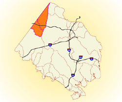
Public Works and Environmental Services

CONTACT INFORMATION: Our administrative offices are open 8 a.m. – 4:30 p.m., Mon - Fri
703-324-5500 TTY 711
12000 Government Center Parkway
Suite 449, Fairfax, Va 22035
Shannon Curtis
Chief, Watershed Assessment Branch

Sugarland Run and Horsepen Creek Watersheds

map of watershed areaLocation
The Sugarland Run and Horsepen Creek watersheds (22.5 square miles and 23.5 square miles, respectively) are located in the northwestern part of Fairfax County, and cross into Loudoun County. Sugarland Run drains to the Potomac River and Horsepen Creek drains into South Fork Broad Run, which then drains into the Potomac River.

Major Streams and Tributaries
Sugarland Run: Major tributaries include Folly Lick Branch, Offuts Branch and Rosiers Branch, as well as some unnamed streams.
Horsepen Creek: Major tributaries include Cedar Run and Frying Pan Branch as well as some unnamed streams.

Unique Features
The town of Herndon is on the border between the two watersheds. Part of the Dulles Airport property is in the Horsepen Creek watershed and Frying Pan Park is also in this watershed.

Improvement Opportunities
The plans identify areas of opportunity for implementing both structural and non-structural improvement projects such as stream restorations, stormwater facility retrofits, community education and stewardship, streamside buffer enhancements and installation of green stormwater infrastructure (GSI). Proposed projects in the plans have recommended priorities. These lists should not be interpreted as specific implementation schedules or a guarantee that the project will be implemented through the planned Capital Improvement Program (CIP). A full list of active or completed Stormwater projects is available online on at Stormwater Improvement Projects or through Jade (Fairfax County's Comprehensive Mapping Application).

Fairfax Virtual Assistant