

The purpose of a floodplain/drainage study is to establish the limits of flooding within or near a proposed development activity when an acceptable delineation does not already exist, or when proposed development may change flood boundaries. A floodplain study is conducted by a licensed professional engineer to determine the water surface elevation and boundaries of flooding for a water body during a storm event that has a 1% probability of occurring in any given year using methods required by the Public Facilities Manual 6-1400. See also Technical Bulletin, 12-03 Use of Existing Flood Hazard Data to Delineate Floodplain Boundaries on Plans. Note: A drainage study is a type of floodplain study. Drainage studies are for when the affected floodplain area is less than 70 acres. Floodplain studies are for when the affected floodplain area is 70 acres or more.
ON THIS PAGE
This information is the most common for how to obtain the necessary approval for your project and is not representative of all the conditions you may encounter.
WHO SHOULD APPLY?
Property owners or their duly authorized agents may submit floodplain studies, however, the study itself must be prepared and certified by a professional engineer licensed by the Commonwealth of Virginia and meeting the respective code requirements.
PLAN AHEAD
Before submitting, ensure you are aware of all applicable regulations and conditions that could affect your project to avoid surprises during the review process. Some of those factors include:
- Zoning Information
- Design Codes and Standards
- Do I Need to Hire a Design Professional?
- Floodplains
- Resource Protection Areas (RPA)
- Grading/Site Plans
- Parking Tabulation
- Types of Soils and Problem Soils
- Researching Site Conditions
To get a detailed description about each regulation and condition, visit our Plan Ahead page.
To verify potential floodplain boundaries impacts to your specific project, use the GIS Floodplain Viewer application.
HOW DO I SUBMIT MY RECORD?
PLUS Application
Apply for your floodplain/drainage study online in PLUS under the Site tab. If you are a first-time user, you must first register for an account.
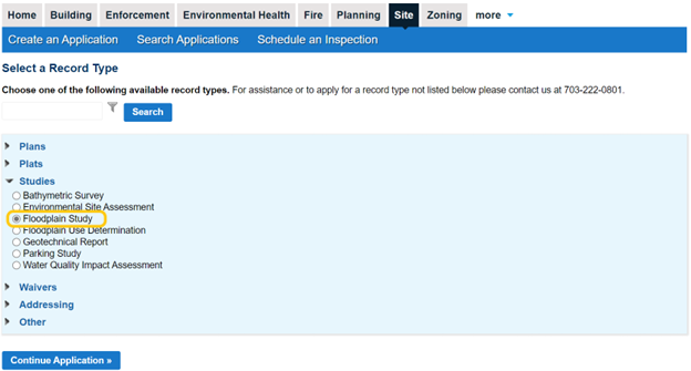
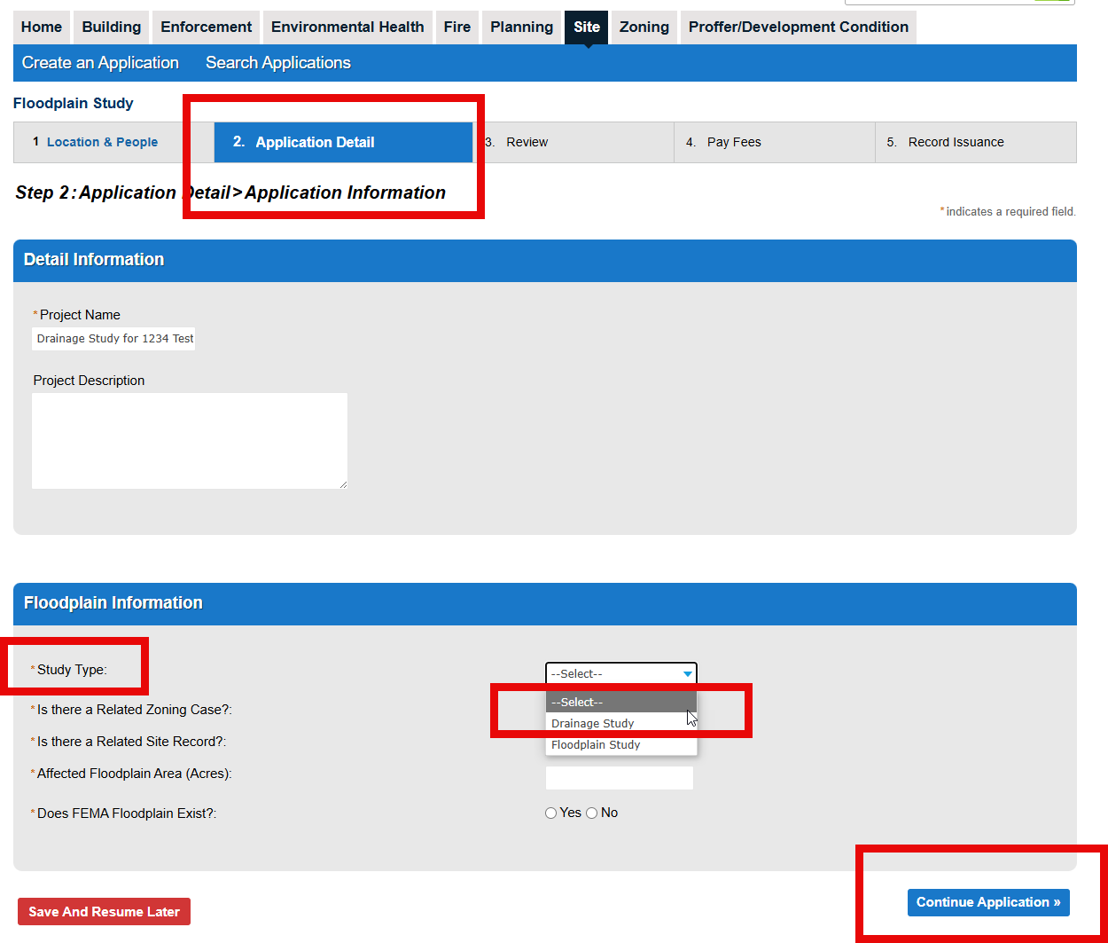
NOTE: A Drainage Study is a type of Floodplain Study. To proceed, continue your application to Step 2: Application Detail and select the appropriate study type based on the size of the affected floodplain area:
- Select Drainage Study if the affected floodplain area is less than 70 acres.
- Select Floodplain Study if the affected floodplain area is 70 acres or more.
Submission Guidelines
Visit our Site-Related Submission Guidelines page for information on how to submit your plan, including strongly encouraged naming conventions.
Tutorial on Uploading Plans and Documents in PLUS
Helpful Instruction Guide:
Requirements
Depending on the scope of your project, one or more of the following may be required:
First Submissions:
- Digital signature - verifiable digital signature of the licensed design professional
- Floodplain Study consisting of a plan depicting the floodplain boundaries, cross-sections and water surface elevations with hydrologic and hydraulic calculations meeting the requirement of the Public Facilities Manual Chapter 6 and specifically Section 6-1400.
- Review fee
Subsequent Submissions:
- Digital signature - verifiable digital signature of the licensed design professional
- Applicant responses - enter responses to all open issues in the PLUS Digital Plan Room
- Review fee
Helpful Videos:
![]() Responding to Issues - YouTube
Responding to Issues - YouTube
![]() Upload Corrected Plans - YouTube
Upload Corrected Plans - YouTube
Helpful Instruction Guides:
Revisions to previously approved plans (per the PFM):
- Digital signature - verifiable digital signature of the licensed design professional
- Revision narrative - separate letter detailing the revision and referencing its general location
- Revision block - updated revision block incorporated as part of the plan or profile sheet
- Certification of No Change - certification that no other changes have been made to the plan or profile except those previously approved
- Changes circled in red
- Review fee
Helpful Videos:
![]() Submitting Revisions in PLUS - YouTube
Submitting Revisions in PLUS - YouTube
Helpful Instruction Guides:
What's Next?
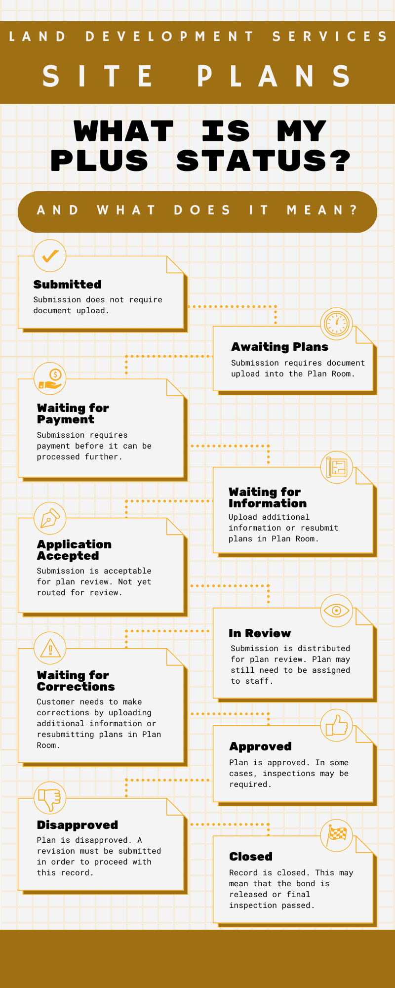
To get a step-by-step guide on PLUS statuses and what they mean, see our What is My PLUS Status? Site Plans Infographic.
Review Process
Staff from the Site Application Center and Site Development and Inspections Division will review your package for completeness and compliance with applicable codes and county ordinances. You will be notified of any deficiencies. Plan corrections, resubmission fees and additional supporting documents may be required.
- Queue times
- Fees
- Common plan comments for site review
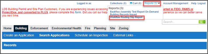
- Workflow Routing Slip to track review and plan assignment
For a detailed summary of application progress, to include the name(s) of assigned review staff, click on “Reports” in the top-right corner of the PLUS screen, when you are in a specific record, and select “Workflow Routing Slip Report.”
Plan and Permit Issuance
Once all reviews are approved and fees have been paid, your approved floodplain study will be available to download from PLUS.
Helpful Video:
![]() Approved Plans - YouTube Video
Approved Plans - YouTube Video
