Public Works and Environmental Services

CONTACT INFORMATION: Our administrative offices are open 8 a.m. – 4:30 p.m., Mon - Fri
703-324-5500 TTY 711
12000 Government Center Parkway
Suite 449, Fairfax, Va 22035
Joni Calmbacher
Director, Stormwater Planning

Dam Basics

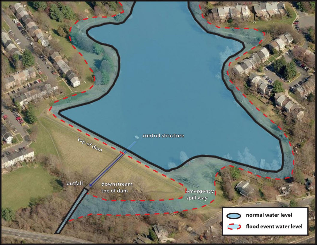
A dam is a man-made barrier that impounds (i.e., collects and confines) water. Dams can serve various functions, such as to control or store runoff, provide drinking water, provide recreational opportunities and more. In Fairfax County, most dams are constructed earth with a concrete control structure. There are thousands of small stormwater management facilities in the county that utilize dams to store excess stormwater runoff from our land in a dry pond or a wet pond. Water in a dry pond drains completely after a rain event, while a wet pond will have a permanent pool. A few larger dams, such as Lake Accotink, provide recreational opportunities or provide a source of drinking water, such as the Occoquan Reservoir.

Dams in Fairfax County

The Fairfax County Department of Public Works and Environmental Services has a Dam Safety Program that is responsible for monitoring about 20 large dams. Learn more at Dam and Flood Safety. However, there are several thousand smaller impoundment structures maintained by the county or private property owners.

Every dam must be maintained to ensure it functions properly. Additional information on maintaining stormwater management facilities is available at Maintenance and Inspections. To report a complaint concerning one of these facilities, please complete the Stormwater Management Pond Maintenance Form.

Though planting on the dam itself is prohibited, planting in and around stormwater management ponds is an option for communities who are interested in enhancing their local facility.

before planting, after planting
Example of a typical dry pond before and after a volunteer planting.

What does a dam look like?

Diagram of dam illustrating control structure, top of dam, outfall, downstream toe of dam, emergency spill way, outline of water as normal water level and dotted line area for flood event water level
Click image to enlarge

The dam diagram depicts a typical wet pond utilizing a dam with a permanent pool. There are several common features found in most dams, these include:

  • Black Line - Normal water elevations.
  • Red Line - Water elevation during a flood event.
  • Control Structure - A structure through which water flow is directed through or over during the majority of rainfall events. Also known as the principal spillway.
  • Emergency Spillway - A channel that is designed to provide additional protection against water flowing over the top of the dam (known as overtopping) and is intended for use under extreme conditions.
  • Combined Spillway - Many facilities have a combined spillway where the control structure acts as both the principal and emergency spillway.
  • Outfall - Structure where water is discharged at normal conditions.
  • Toe of Dam - The portion of the dam slope that intersects the natural ground surface.
  • Top of Dam - The elevation of the uppermost surface of the dam.


Fairfax Virtual Assistant