Lake Fairfax Park

703-471-5415 TTY 711
1400 Lake Fairfax Drive
Reston, VA 20190
John Britz
Site Manager

Department Resources

Lake Fairfax Orienteering

Overview

Lake Fairfax Park consists of 476 acres of parkland that provides many options to enjoy the outdoors, including camping, biking, and hiking. The Park is also home to a wide variety of archaeological sites, protected plant life, and is a vital part of the Chesapeake Bay watershed. It is also now home to a 10-point practice orienteering course, as well as a 23-point main course for visitors of all ages.

To minimize the impact of park visitors damaging sensitive sites, the Lake Fairfax Park Orienteering Course was constructed in the Park’s open areas as a low-environmental impact course at the request of the Fairfax County Park Authority. This makes the course well-suited for visitors, especially families and youths, looking to learn how to use a compass and pace count, or GPS to navigate between points. 

The course consists of 23 control points, with the start point being the brick wall bordering the stairway adjacent to the park manager’s office. Unlike a traditional orienteering course, this course does not require the participants to use a map to complete the course. Instead, participants can download a score sheet that contains the compass bearings and distances to complete one of the eight variations of the course. This course can be completed with only a compass or a compass app found on your smartphone.

Additionally, for those who want to practice using a GPS or smartphone GPS app, such as Gaia GPS, participants also have an option of a downloading GPS-based score sheet for the course that contains the longitude and latitude coordinates of the control points.

FAQs

The practice orienteering course is intended to help teach how to take a bearing and measure a distance overland using a pace count.

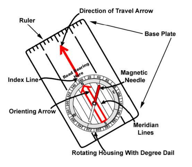
All that is needed to complete the practice orienteering course is a hand-held compass or a smartphone with a compass app installed on it.

The practice orienteering course is located near the skate park and directly across the road from Field 7.

The practice orienteering course consists of a known 100-foot pace count and eight numbered control points with markers that provide the distance and direction to each point. 

One way to measure how far you walk on the orienteering course is to use your pace count. A pace is equal to one natural step, about 30 inches long for an average-height adult. To accurately use the pace count method on the Lake Fairfax Park Orienteering Course, you must know how many paces it takes you to walk 100 feet. To determine this, you must walk an accurately measured course and count the number of paces you take. A pace course can be as short as 100 feet, but it can also be a distance like 100 meters.

Participants should start by determining their pace count. The practice orienteering course has two posts spaced 100 feet apart. Participants should walk between the two posts while counting the number of paces it takes to cover the 100 feet. People new to orienteering would benefit from doing this several times to get an average number of paces to walk 100 feet. Additionally, traditional orienteering courses are timed events, so participants may want to also determine their jogging or running pace counts.  

Once you have determined how many steps it takes you to walk 100 feet, you can determine how many steps it will take you to cover any distance. For example, if your pace count for 100 feet was 40 steps, your pace count for 25 feet would be 10 steps. Similarly, for 50 feet your pace count would be 20 steps, 30 steps for 75, and 60 steps for 150 feet.

The following four steps will help you use your compass to complete this course.

  1. Hold the compass a flat, preferably on nonmetallic surface such as the ground or stiff cardboard.
  2. Rotate the degree dial to line up the direction (degrees) you need to travel to find your next control point with the Index Line and the Direction of Travel Arrow.
  3. Rotate the compass until the Floating (Red) Needle is over the Orienteering Arrow (shed). “Red is in the Shed”.
  4. When the floating (red) needle is in the “shed” the Direction of Travel Arrow will be pointing in the direction you need to go to navigate to your next control point.

Image of compass

Navigating between the practice course control points 

Beyond the pace count portion, the practice orienteering course also consists of eight control points, numbered one through eight, that are in close proximity to each other. This is done so participants can see the next control point and practice taking a compass bearing and using their pace count. On each post, there is a sign that gives the compass direction and distance to the next point. Participants should align their compass to the direction shown on the signpost to determine which control point marker is the next in line. They can then compare their pace count to the distance that is shown on the control point marker. Participants can practice navigating between points to gain familiarity with how to use a compass and improve the accuracy of their pace count.

Additional opportunities to practice using a compass and pace count

In addition to completing the eight-point practice course, participants can download the practice guide, which includes a table that contains additional control point combinations (e.g., point two to point seven, point six to point one, etc.) This table does not provide the distance and direct to the next point.  Instead, participants will use a diagram of the course to identify the numbered points and will determine the distance and direction solely using their compass and pace count. In addition to the table, there is an associated answer sheet on practice course website.  

Resources

Fairfax Virtual Assistant