Park Authority

CONTACT INFORMATION: Open during regular business hours 8 a.m. - 4:30 p.m., Monday - Friday
703-324-8700 TTY 711
12055 Government Center Pkwy.
Fairfax, Virginia 22035
Jai Cole
Executive Director

Department Resources

Related Resources

Bike Trails and Biking

Pump Tracks

Cyclist rides up a hill on the Lake Fairfax Pump Track
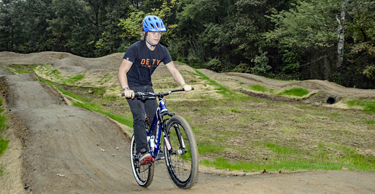
Pump tracks are small, looping bicycle trail systems that riders navigate by pumping with their arms and legs, rather than pedaling.
The Park Authority has pump tracks at Lake Fairfax Park and Brookfield Park.
The track at Lake Fairfax in Reston measures 50 x 100 feet and is suitable for bicyclists of all ages and abilities. See photos on our Flickr page.
The Brookfield Park track in Springfield opened in April 2018. Once again, there are photos on Flickr:
 

Biking and Stewardship

Biking through natural areas takes you into a world of beauty, history, and biological diversity. While reveling in the wind through your hair, remember to be a good steward of cultural and natural resources.

There are Native American and Civil War artifacts all over our county, and most of their locations are unmarked. Biking off trails can disturb artifacts or lead to erosion and other environmental damage. So be a good steward of the land.

Be aware, and bike with care.

Major Bicycle Trails:

  • BURKE LAKE PARK TRAIL
    Lakeside trail, natural surface and stonedust. Park entrance fee of $5 charged to non-Fairfax County residents on weekends and holidays, March-November. Connects to South Run Stream Valley trail. Call 703-323-6601 for information - total distance 4.6 miles
  • ACCOTINK CREEK TRAIL (CCT)
    Stream valley trail, stonedust and asphalt from Thaiss Park off Pickett Road in the City of Fairfax to King Arthur Road, then accessible asphalt from King Arthur Road to the north end of Wakefield/Americana Park south of Route 236 (see below for additional mileage) - includes Eakin Community Park - total distance 4.3 miles
  • WAKEFIELD PARK/LAKE ACCOTINK PARK TRAIL (CCT)
    Natural surface and stonedust trail extending from the north side of Wakefield/Americana Park at Route 236 to the Lake Accotink dam, then accessible asphalt from the dam parking lot to Hunter Village Drive south of Old Keene Mill Road, stonedust south to Fairfax County Parkway. Mountain biking in both parks, night riding in Wakefield. Call Lake Accotink Park (703-569-3464) or Wakefield Park (703-321-7081) for information - total distance 6 miles
  • HOLMES RUN TRAIL
    Stream valley trail, stonedust and asphalt. From Annandale Road (at the end of Hockett Street) to Sprucedale Drive (near Sleepy Hollow Road) and asphalt from Columbia Pike to the City of Alexandria - includes Valleycrest Park , Roundtree Park - total distance 2.4 miles
  • LONG BRANCH TRAIL
    Stream valley trail, stonedust. From Braddock Road at Wakefield Chapel Road to Olley Lane - includes Canterbury Woods Park, Rutherford Park - total distance 2.75 miles
  • SUGARLAND RUN TRAIL
    Stream valley trail network, asphalt. From Sugarland Road or Dranesville Road south to Runneymede Park then connecting to the W&OD trail - total distance on main trail to Town of Herndon line 3 miles, [side trails provide an additional 3 miles, connecting trail (Town of Herndon) to W&OD an additional .75 miles]
  • SOUTH RUN TRAIL
    Stream valley trail, asphalt. From Burke Lake Dam south, crossing under Lee Chapel Road, to South Run District Park and RECenter and on to Rushing Creek Drive. A very short on-road section connects from Rushing Creek Drive to asphalt trail along Pohick Road and on to Laurel Hill Greenway (see below) - total distance to Rushing Creek Drive 4 miles, [Rushing Creek to connection to CCT an additional .4 miles]
  • CUB RUN TRAIL - NORTH
    Stream valley trail network, asphalt. From Route 29 north to Honsena Drive - total mileage 5 miles
  • CUB RUN TRAIL - SOUTH
    Stream valley trail network, asphalt. From Route 29 south to Compton Road - total mileage 2.5 miles
  • LAUREL HILL GREENWAY (CCT)
    Asphalt and stonedust trail extending from Creekside View Lane to Occoquan Regional Park - total distance 4.5 miles [7 miles of natural surface trail loops for mountain bikes can be accessed from the Greenway trail]
  • ROCKY RUN TRAIL
    Stream valley trail, stonedust. From Walney Road/Cabell's Mill parking lot in E. C. Lawrence Park to Fairfax County Parkway - includes Greenbriar Park - total distance 3.4 miles

Bike Trail Safety Tips

  • Don't blaze new trails - Cutting a fresh path can damage sensitive environmental areas or unmarked historical sites. Steep inclines are particularly susceptible to erosion.
  • Bike only when trails are dry - Biking on wet trails causes rutting and erosion.
  • Obey all signs - "No biking" signs are posted in areas especially vulnerable to resource damage.
  • Let the natural terrain stay natural - Do not construct jumps or otherwise mark trails.

Many county residents and visitors use the parks. Please be considerate.

  • Bike at a reasonable speed - Maintain control of your bike at all times.
  • Yield the right-of-way
  • Announce your intention to pass - Pass on your left when approaching other trail users moving at a slower speed.
  • Dismount approaching horses - Dismount and walk your bike. Horses can bolt when frightened

  • Wear a helmet
  • Know your limits
  • Ride within your abilities
Fairfax Virtual Assistant