RPA boundary delineation studies, or RPA plans, are required for all site-related plans on which RPAs are shown on the adopted county map (e.g., infill lot grading plans, subdivision plans, rough grading plans, site plans). Additionally, for infill lot grading plans, the submitting engineer must certify on the plan that all the features that comprise the RPA have been reviewed and that the RPA boundary depicted on the plan is accurate. It is the applicant’s responsibility to show the appropriate RPA boundaries, applying the criteria in section §118-1-7 of the Chesapeake Bay Preservation Ordinance (CBPO), on all plans of development submitted for review.
The Public Facilities Manual (PFM) and CBPO set forth the criteria for conducting and submitting site-specific boundary delineation studies. Site-specific studies to determine the exact width of the RPA may be required before approval to start land-disturbing activities on properties in or near RPAs.
For building permit applications, where a grading plan is not required (i.e., total disturbance is less than 2,500 square feet), the RPA boundary shown on the associated house location plat may be based on the adopted county map and not require a site-specific delineation plan.
For more information, see Letter to Industry dated April 25, 2022.
ON THIS PAGE
This information is the most common for how to obtain the necessary approval for your project and is not representative of all the conditions you may encounter.
WHO SHOULD APPLY?
Homeowners or their duly authorized agents may submit resource protection area plans, however, the plan itself must be certified by a professional engineer, land surveyor, architect or landscape architect licensed by the Commonwealth of Virginia and meeting the respective code requirements.
PLAN AHEAD
Before submitting, ensure you are aware of all applicable regulations and conditions that could affect your project to avoid surprises during the review process. Some of those factors include:
- Zoning Information
- Design Codes and Standards
- Do I Need to Hire a Design Professional?
- Floodplains
- Resource Protection Areas (RPA)
- Grading/Site Plans
- Parking Tabulation
- Types of Soils and Problem Soils
- Researching Site Conditions
To get a detailed description about each regulation and condition, visit our Plan Ahead page.
HOW DO I SUBMIT MY RECORD?
PLUS Application
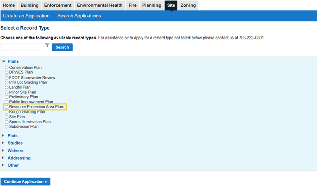
Apply for your resource protection area plan online in PLUS under the Site tab. If you are a first-time user, you must first register for an account.

Submission Guidelines
Visit our Site-Related Submission Guidelines page for information on how to submit your plan, including strongly encouraged naming conventions.
Tutorial on Uploading Plans and Documents in PLUS
Helpful Instruction Guide:
Requirements
Depending on the scope of your project, one or more of the following may be required:
First Submissions:
- Must meet the requirements in Public Facilities Manual Section 6-1704
- Must be submitted and approved as a prerequisite to approval of any associated site-related plan. For additional information, see Letter to Industry 22-01, dated April 25, 2022.
- Review fee ($419.00 + plan baseline linear footage)
Subsequent Submissions:
Helpful Videos:
 Upload Corrected Plans - YouTube
Helpful Instruction Guides:
What's Next?
To get a step-by-step guide on PLUS statuses and what they mean, see our What is My PLUS Status? Site Plans Infographic.
Review Process
Staff from the Site Application Center, Minimum Submission Review team, Health Department (if on well or septic), and Site Development and Inspections Division will review your package for completeness and compliance with applicable codes and county ordinances. You will be notified of any deficiencies. Plan corrections, resubmission fees and additional supporting documents may be required.
- Queue times
- Fees
- Common plan comments for site review
- Workflow Routing Slip to track review and plan assignment
For a detailed summary of application progress, to include the name(s) of assigned review staff, click on “Reports” in the top-right corner of the PLUS screen, when you are in a specific record, and select “Workflow Routing Slip Report.”

Plan Issuance
Once all reviews are approved, fees have been paid and all associated post-approval conditions have been satisfied, your land disturbance permit and approved plans will be available to download from PLUS.
Visit the Meeting Approval Condition web page to learn more about your plans specific approval conditions, including where to locate them in PLUS and to get the appropriate form for each condition. Once completed, submit all required documents using this form.
Helpful Video:
 Approved Plans - YouTube Video


