

RPAs are regulated waterbodies and associated corridors of environmentally sensitive land that lie alongside or near the shorelines of streams, rivers and other waterways which drain into the Potomac River and eventually into the Chesapeake Bay. In their natural condition, RPAs protect water quality, filter pollutants from stormwater runoff, reduce the volume of stormwater runoff, prevent erosion, and perform other important biological and ecological functions. In Fairfax County, RPAs include any land characterized by one or more of the following features:
- Tidal wetland;
- Tidal shore;
- Water body with perennial flow;
- Nontidal wetland connected by surface flow and contiguous to a tidal wetland or water body with perennial flow;
- Buffer area that includes any land within a major floodplain and any land within 100 feet of a feature listed in 1-4.
Development, uses and activities within RPAs must comply with the County’s Chesapeake Bay Preservation Ordinance (CBPO), Chapter 118 of the Code of the County of Fairfax to protect and restore the quality of state waters.
The county has prepared guidance maps showing estimated locations of the RPAs.
There are two ways to view the RPA boundaries on the county’s website:
- The Watershed and Resource Protection Area Viewer is the simplest way to view the Watershed and RPA boundaries by entering the property address.
- JADE is a more comprehensive mapping application with over 170 layers to view, combine and analyze. The RPA boundary is one of the available layers in the online GIS system. Further instructions are available.
The above mapping tools depict the general presence and location of regulated areas. However, the determination of the exact width and location of the RPA boundary may be required by a site-specific study before the county can grant approval to start land-disturbing activities on properties in or near RPAs. For more information, see the Letter to Industry dated April 25, 2022 or the “When are site-specific RPA delineations required and Why?” FAQ.
Any development, land disturbing activity or other use within an RPA generally requires prior approval from the county. The specific type of application and procedure for obtaining the approval depends on the nature and extent of the encroachment. For information regarding a specific project and associated application requirements, please contact a stormwater specialist at 703-324-1720, TTY 711.
Existing structures and uses in the RPA including lawns, gardens and other maintained landscaping, may remain and be maintained as they existed when the RPA was designated on the property (e.g., July 1, 1993 or November 18, 2003) but may not be expanded upon unless a waiver or exception is granted.
Subject to county approval, and to maintain the functional value of the buffer area, vegetation may be removed from the 100-foot buffer for the following reasons:
- To provide reasonable sight lines, general wood lot management and habitat management. Any vegetation removed must be replaced with vegetation that provides equivalent water quality benefits and environmental protection. Form to request approval.
- To create access paths. Such paths and appurtenances cannot cause erosion. Form to request approval.
- To remove dead, dying or diseased trees and shrubs, and to remove noxious weeds or invasive exotic plants. Any vegetation removed requires replacement vegetation equally effective in providing water quality benefits and environmental protection. Process to request approval.
- To provide for shoreline erosion control. Buffer must be reestablished with native, woody vegetation. Form to request approval.
- Development is not permitted when there is sufficient buildable area outside the 100-foot buffer or if the property was subdivided after the Chesapeake Bay Preservation Ordinance (CBPO) or a subsequent amendment was adopted (e.g., July 1, 1993 or November 18, 2003). For more information, see the “What are the loss of buildable area provisions?” FAQ.
- Accessory structures like sheds, gazebos, pools, or detached garages may not be located within the 100-foot buffer without the approval of an exception via a public hearing with associated fees. Form to begin the process.
- Clear-cutting of vegetation is not permitted nor is the removal of native vegetation to create lawns.
- Application of pesticide and fertilizer is strongly discouraged.
The construction of sheds in the RPA may be allowed but are subject to an exception process requiring a public hearing and associated fees. The first step in the exception application process is to complete and submit a Water Quality Impact Assessment. Sheds should only be located within an RPA when there is no reasonable alternative for locating the shed outside of the RPA boundary. For more information, see the “What are the requirements for the construction of accessory structures?” FAQ. A pre-application meeting is strongly recommended before submitting the WQIA to pursue an application requiring a public hearing for an accessory structure in the RPA. Please submit your request here.
Fences are allowed in the RPA without an exception or waiver and subject to the following design requirements which collectively maintain the functional value of the buffer:
- Fences should be designed so that they do not inhibit or alter surface flow (i.e., water must be able to flow under and through the fence unimpeded).
- Vegetation may only be removed to provide for the actual placement of the fence.
- Where vegetation is removed, it must be replaced with other native vegetation that is equally effective in retarding runoff, preventing erosion and filtering stormwater runoff.
- Fences should be located to avoid the removal of trees.
If the fence is to be placed in an area that is an existing (pre-RPA establishment) maintained lawn, the revegetation requirement would not be applicable.
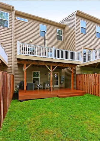
New decks are commonly treated as minor additions under the Chesapeake Bay Preservation Ordinance (CBPO) and therefore allowed, subject to approval of an administrative waiver (WAIV). The administrative waiver process is available only for minor additions to homes constructed prior to the effective date of the RPA map amendment (e.g., July 1, 1993 or November 18, 2003).
Submit an RPA Minor Additions (Walk Through WRPA) waiver in PLUS. A separate Water Quality Impact Assessment (WQIA) submission is not required. Additionally, if the deck is uncovered and there is no impervious area proposed, there are no fees associated with the application. For more information, see the “What are the requirements for the construction of minor residential additions?” FAQ.
For maintenance of an existing deck, where no additional changes or encroachments are proposed beyond replacing boards or railings, use the RPA Exemption/Exception Request application and check § 118-5-1 (WAIV) – Nonconforming uses and structures. There is no fee associated with this application.
For a complete tear down/rebuild of an existing deck within the same location, submit a minor Water Quality Impact Assessment application (WQIA) for redevelopment. Table 4 on page 7 of the application is not required. There is no fee associated with this application.
For submission details, visit one of the following permit library pages:
- For a maintenance request, reference the “Permit Library: Waivers” page.
- For a redevelopment request, reference the “Permit Library: WQIA” page.
The construction of patios in the RPA may be allowed but are subject to an exception process requiring a public hearing and associated fees. The first step is to submit a Water Quality Impact Assessment (WQIA) record in our online permitting system, PLUS. Please select “Yes” at the bottom of Page 1 of the WQIA application to note the project is for an Article 6 exception. A pre-application meeting is strongly recommended before submitting the WQIA to pursue an application requiring a public hearing for an accessory structure in the RPA. Please submit your request here.
Patios are considered accessory structures and are subject to specific criteria under the Ordinance (Sections 118-6-6 and 118-6-8). For more information, see the “What are the requirements for the construction of accessory structures?” FAQ.
Alternatively, low-level pervious decks (i.e., ground level decks which allow water to pass through) may be installed without a public hearing. For more information on the process and associated form, see the “Are decks allowed within the RPA?” FAQ above.
Yes. Non-compliance with the RPA restrictions is a violation of the Chesapeake Bay Preservation Ordinance (CBPO) and can result in penalties. At a minimum, violators will be required to restore the RPA in accordance with the CBPO and Fairfax County’s Public Facilities Manual (PFM). An appropriate restoration plan must be developed and submitted to the Department of Land Development Services for review and approval. The objective of the plan is to restore the RPA’s primary functions so it can effectively remove pollutants from stormwater runoff, which is achieved via the planting of trees, shrubs and ground cover. Planting densities are prescribed by CBPO §118-3-3(f) and the PFM.
In addition to preparing a restoration plan, any person who violates any provision of the CBPO may be subject to civil penalties up to $5,000 per day of violation.
Generally, if a commercial or residential property (i.e., lot) existed prior to the effective date of the Chesapeake Bay Preservation Ordinance (CBPO) amendments, November 18, 2003, and consequently the buildable area of the lot was so impacted by the delineation of an RPA to a degree that the property could not be reasonably developed then it may qualify for the provisions of the loss of buildable area under the CBPO. Specifically, the loss of buildable area provision allows for construction of 5,000 square feet of impervious (i.e., a surface comprised of material that significantly impedes or prevents natural infiltration of water into the soil) area in the RPA exclusive of the driveway, and 10,000 square feet of disturbed area in the RPA exclusive of the driveway and septic field. An administrative waiver is available for the construction of new homes on lots platted prior to the effective date of the Chesapeake Bay Preservation Ordinance (CBPO) amendments, November 18, 2003.
For a project to qualify for an administrative approval the allowed encroachment must be the minimum necessary to afford relief and may only extend 50 feet into the RPA. Mitigation of the encroachment will be required. The construction of new homes in the RPA not meeting the above requirements may still be possible but would be subject to an exception process requiring a public hearing. For more information, please contact a stormwater specialist at 703-324-1720, TTY 711.
The construction of new homes in the RPA not meeting the above requirements may still be possible but would be subject to an exception process requiring a public hearing. A pre-application meeting is strongly recommended before submitting the WQIA to pursue an application requiring a public hearing. Please submit your request here.
A minor addition is an addition that has a footprint of 1,000 square feet or less or does not comprise more than 2 percent of the lot area up to a maximum of 2,500 square feet, whichever amount is greater. The eligibility for such encroachments depends on when the home was built. In determining eligibility, the date of construction of the home is the date that the Residential Use Permit (RUP), “Occupancy Permit”, for the home was issued.
- To add a minor addition that encroaches into a 1993 RPA mapping designation, the home must have been constructed prior to July 1, 1993 (effective date of the Chesapeake Bay Preservation Ordinance).
- To add a minor addition that encroaches into a 2003 RPA mapping designation, the home must have been constructed prior to November 18, 2003 (effective date of the 2003 amendments).
For an allowed, residential minor addition exception, the total new impervious (i.e., a surface comprised of material that significantly impedes or prevents natural infiltration of water into the soil) area that may be added to the lot is cumulative. For example, if you obtain a minor addition exception for 800 square feet of impervious area and decide to apply for another minor addition exception a year later, you would have only 200 square feet of impervious area allowed under the minor addition exception, not an additional 1,000 square feet. The cumulative limit on the maximum additional impervious area shall continue indefinitely, regardless of ownership of the property.
If the associated land disturbance is less than 2,500 sq. ft., submit an RPA Minor Additions (Walk Through WRPA) waiver in PLUS. A separate Water Quality Impact Assessment (WQIA) submission is not required. If the total proposed disturbance exceeds 2,500 square feet and requires a grading plan, use the RPA Exemption/Exception Request Form to request the exception.
Note: Detached structures are not considered minor additions but considered accessory structures. The county’s ordinance for accessory structures is based on the state regulations which do not allow detached structures to be treated as minor additions. For more information on detached structures, see the “What are the requirements for the construction of accessory structures?” FAQ. A pre-application meeting is strongly recommended before submitting the WQIA to pursue an application requiring a public hearing for an accessory structure in the RPA. Please submit your request here.
The construction of accessory structures, such as detached garages, retaining walls, patios and sheds, in the RPA may be possible but are subject to the findings listed in county code §118-6-6 and the criteria in §118-6-8. A public hearing is required, and decisions are made by the Exception Review Committee (ERC). A pre-application meeting is strongly recommended before submitting the WQIA to pursue an application requiring a public hearing for an accessory structure in the RPA. Please submit your request here. The process involves several steps:
- Complete and submit a Water Quality Impact Assessment (WQIA)
Use the PLUS system to submit the WQIA form along with supporting narrative, plats, water quality computations, and landscape plan. The WQIA should demonstrate that the proposed RPA restoration measures are adequate to offset the impacts on water quality resulting from the proposed RPA disturbance. See more information about WQIA submission in our Permit Library.
Once submitted, staff will review the package for completeness and issue a letter confirming package completion.
- Submit the RPA Exception Request (WAIV)
Use the PLUS system to submit the Exception Request Form along with the Plat showing nature and extent of RPA encroachment and proposed restoration plan. See more information about WAIV submission in our Permit Library.
Staff will review the exception request for completeness and issue a letter confirming package completion. Public hearing is usually scheduled within 3 months of the date of this letter.
- Staff Review and Recommendation
Staff will prepare a report with recommendation to the Exception Review Committee based on findings outlined in §118-6-6 of Chapter 118. Staff will advertise the public hearing and publish the staff report for public access.
- Public Hearing Process
The hearing is typically held at Herrity Building, 9th floor (12055 Government Center Parkway). It begins with a staff briefing, followed by open discussion. ERC members will vote on approval or denial of the case. The case may be deferred if additional information is required.
Given the technical aspects involved in the application process, we strongly recommend hiring a consultant specialized in RPA applications. For more information, please contact a stormwater specialist at 703-324-1720, TTY 711.
A Water Quality Impact Assessment (WQIA) is an analysis of the impacts on water quality when a project is proposed within an RPA. The purpose of the WQIA is to ensure protection of RPAs consistent with the goals, objectives and requirements of the Chesapeake Bay Preservation Ordinance (CBPO) to:
- Identify the impacts of the proposed project on water quality.
- Ensure that the proposed land disturbance will occur in a manner that will be least disruptive to the natural function of RPAs.
- Propose mitigation that will address water quality protection through preserving or restoring all buffer functions including stormwater pollutant removal, erosion and sediment and runoff control.
WQIA’s are required for any land disturbance, development or redevelopment within an RPA unless exempt under Article 5 or unless waived by the Director of Land Development Services in accordance with the provisions of county code §118-6-5.
For more information, please see Letter to Industry #20-02 and the Water Quality Impact Assessment Application.
Boat docking structures and seawalls (bulkheads) are water dependent structures, and are allowed in the RPA, per the Chesapeake Bay Preservation Ordinance (CBPO) §118-2-1, but only with a county-approved Water Quality Impact Assessment. Before any construction on the shoreline or water’s edge begins, permits and approvals from the respective federal, state or local agencies will likely be required. The number and type of necessary permits and approvals will vary depending on the type, size and location of the project. For more information, see the Fairfax County Tidal Shoreline web page.
Site-specific delineations of RPAs are much more accurate than the county’s illustrative mapping.
The first county RPA guidance maps were adopted in 1993 and were prepared using existing map information to estimate the RPA features specified in the Chesapeake Bay Preservation Ordinance (CBPO) §118-1-7(b). The maps were updated in 2003 based on a 2-year field study to determine the limits of all perennial streams in the county. There have since been separate amendments revising RPA guidance maps for smaller areas of the county. The maps provide landowners with a tool showing the general presence and location of regulated areas.
Given that the county RPA guidance maps are not based on site-specific, field-verified features, RPA boundary delineation studies are required for all site-related plans on which RPAs are shown on the adopted county map (e.g., infill lot grading plans, subdivision plans, rough grading plans, site plans). Additionally, for infill lot grading plans, the submitting engineer must certify on the plan that all the features that comprise the RPA have been reviewed and that the RPA boundary depicted on the plan is accurate. It is the applicant’s responsibility to show the appropriate RPA boundaries, applying the criteria in §118-1-7 of the CBPO, on all plans of development submitted for review.
The Public Facilities Manual (PFM) and CBPO set forth the criteria for conducting and submitting site-specific boundary delineation studies. Site-specific studies to determine the exact width of the RPA may be required before approval to start land-disturbing activities on properties in or near RPAs. Please note that the adopted RPA map or the RPA layer (such as in JADE) is not revised when a site-specific RPA Delineation Plan is approved. Approved site-specific RPA Re-delineation Plans may be obtained through Fairfax County’s Site Plan Viewer, or requested from Fairfax County Land Development Services, Records and Information Management Branch, 5th floor of the Herrity building, 12055 Government Center Parkway, Fairfax, and via email at LDSRecords@fairfaxcounty.gov.
For building permit applications, where a grading plan is not required (i.e., total disturbance is less than 2,500 square feet), the RPA boundary shown on the associated house location plat may be based on the adopted county map and not require a site-specific delineation.
For more information, see Letter to Industry dated April 25, 2022.
Suspected violations of the Resource Protection Area (RPA) may be reported by submitting a complaint via our online permitting system, PLUS. Your complaint will be reviewed in the order it was received. Inspections are typically scheduled within 2-3 business days from the processing of the complaint. Information submitted as part of a compliant, including your name and other personally identifying information, may be subject to public disclosure under the Virginia Freedom of Information Act. Complaints may also be submitted anonymously.
In accordance with Chapter 118-5-1, you can continue to maintain an existing use(1) or existing structure(2) in your yard(3) that was established prior to the RPA designation as long as:
- The use or structure being maintained existed prior to the establishment of the RPA designated(4) on that specific parcel or property, or the use or structure has been approved through an exception or site-related plan(5); and
- At the time the use or structure was established it was done so in accordance with all applicable provisions of the County Code in effect at the time (e.g., obtained any required building permits, met appropriate Zoning setbacks, obtained a grading plan if the associated disturbance exceeded 2,500 sq. ft.); and
- The use or structure is not enlarged or expanded. Expansion or enlargement of the existing use or structure (e.g., widening an existing patio, shed or establishing a larger lawn area that would encroach into natural RPA buffer) would require formal approval from the Department of Land Development Services through an appropriate RPA request. Change of uses (lawn, flower bed, vegetable garden, shrubs, trees) that does not result in additional impervious areas within existing maintained area (based on the criteria in a and b above) is not considered enlargement or expansion.
Where the use or structure was established with a site-related plan (e.g., grading or subdivision plan), the limits of disturbance shown on the approved plan are to be honored. Where the use or structure was established without a site-related plan, the limits of disturbance are assumed to be no more than 10 feet beyond a building, and not more than 5 feet beyond other uses, such as retaining walls, driveways and patios. Area within the limits of disturbance is considered previously disturbed RPA and covered under Chapter 118-5-1.
If there is a need to remove vegetation (a dead dying or diseased tree, or a tree that causes a risk to life or property, or invasive species and noxious weeds, etc.) within an RPA buffer that was either naturally vegetated or established pursuant to 118-3-3, it is not permitted to be maintained under 118-5-1. Instead, submit an RPA waiver application (WAIV) via our online permitting system, PLUS. For submission details, visit the Removal of Vegetation in the RPA webpage.
An application is required for any new structure/impervious area or expansion of existing use/structure in the RPA. Please note that in addition to the RPA regulations in Chapter 118, land disturbance is regulated under Chapter 104 of the County code. Areas subject to flooding are regulated under the Zoning Ordinance Section 5105.
- Use means any purpose for which a structure or a tract of land may be designed, arranged, intended, maintained, or occupied; also, any activity, occupation, business or operation carried on, or intended to be carried on, in or on a structure or on a tract of land. (Section 118-1-6. Definitions (cc)) It includes lawn and associated trees, shrubs, groundcover, and ornamental and vegetable gardens.
- Existing structures refers to existing sheds, retaining walls, patios, play set, sport courts, swimming pools, parking lots, driveways, walkways, boat ramps, and docks.
- Yard means any open space on the same lot with a building or building group lying between the building or building group and the nearest lot line, unobstructed from the ground upward and unoccupied except by specific uses and structures allowed in such open space by the provisions of this Ordinance. (Zoning Ordinance, Section 9102).
- The aerial images from the Fairfax County JADE may be used as supporting information regarding the establishment of a use on the property prior to the designation of RPA.
- Where the use/structure was established with a site-related plan (e.g., grading or subdivision plan), area within the limits of disturbance is considered previously disturbed RPA and covered under Chapter 118-5-1. Where the use/structure was established without a site-related plan, the limits of disturbance are assumed to be no more than 10 feet beyond a building, and not more than 5 feet beyond other uses. For more information on how land disturbance is calculated, visit Land Disturbance 101.
Redevelopment is defined by the Chesapeake Bay Preservation Ordinance as the process of developing land that is or has been previously developed. Redevelopment may be allowed within an RPA if otherwise permitted by the Zoning Ordinance and other law if there is: (1) no increase in the amount of impervious cover (a surface material that significantly impedes or prevents natural infiltration of water into the soil) and, (2) no further encroachment within the RPA.
This means the redevelopment must be constructed in such a way that water may continue to infiltrate into the underlying soils (so no roofed structures) and may not extend further into the RPA than the previous disturbance limits associated with the original approved development/improvement. To apply under redevelopment, prepare and submit a Water Quality Impact Assessment (WQIA).
Land development, uses and activities within RPAs are regulated under the Chesapeake Bay Preservation Ordinance (CBPO), Chapter 118 of the Code of the County of Fairfax. Under the regulations, agricultural uses and activities within the RPA, such as crop production and pasture, require a soil and water quality conservation assessment to evaluate the effectiveness of existing practices, and if deemed necessary, require a soil and water conservation plan approved by the Northern Virginia Soil and Water Conservation District Board, before they may commence.
A soil and water conservation plan depicts site-specific strategies for soil erosion control, nutrient management and pest management. The regulations require the plans to include a combination of best management practices for protection against a range of pollutants in addition to preventing soil erosion.
Under the CBPO, “land upon which agricultural activities are being conducted” is land which yields agricultural products, such as the following:
- Field crops;
- Horticultural specialties; and
- Livestock and livestock products (horses, poultry, cattle, sheep, etc.)
For further information, please reach out to the Northern Virginia Soil and Water Conservation District at 703-324-1460 or via email at ConservationDistrict@fairfaxcounty.gov.
Using the above FAQs, first determine the appropriate RPA request form based on your project. Once completed, submit your RPA form and/or Water Quality Impact Assessment (WQIA) electronically via the PLUS Portal. For more information on PLUS, watch our How-to Videos. For more information regarding the RPA submission process, visit the Facilitation and Addressing Center’s website or email LDSFAC@fairfaxcounty.gov.
If the proposed project is located within 15 feet of a floodplain boundary (or for decks only, within the floodplain boundary), a Floodplain Use Determination (FPUD) is required separate from the RPA request. Click the FPUD form for more details, including where and how to submit. NOTE: the FPUD must be approved by the Site Development and Inspections Division prior to the RPA request being approved. To determine whether your project is within the floodplain boundary limits, use the JADE interactive mapping application.
Please note that all floodplains are not yet mapped. An unmapped floodplain may be present on the property if the drainage area to the stream is greater or equal to 70 acres. Please turn on the 70-360 Acre Streams & Buffers layer which can be found from the layer tool in the bottom left of the Jade mapping tool, under Infrastructure & Environment, Hydrology, Flood.
To determine the appropriate RPA request form, review the above FAQs based on your project.
Memorials are treated as historic preservation activities under the Chesapeake Bay Preservation Ordinance (CBPO) Section 118-5-3, and therefore allowed, subject to approval of an administrative waiver with the following design requirements:
- Memorials should be designed so that they do not inhibit or alter surface flow (i.e., water must be able to flow over or around the memorial unconcentrated);
- Where vegetation is removed, it must be replaced with other native vegetation that is equally effective in retarding runoff, preventing erosion and filtering stormwater runoff;
- The location of the memorial should be optimized to minimize encroachment into the Resource Protection Area and any adverse impacts on water quality; and
- Memorials (i.e., flag stone, or other impervious material) must be placed by hand or using handheld equipment, with a maximum impervious area of 100 square feet.
Other types of memorials, that cannot be placed by hand or handheld equipment, may be allowed in the RPA but are subject to an exception process requiring a public hearing and associated fees.
A pre-application meeting is strongly recommended before submitting the WQIA to pursue an application requiring a public hearing. Please submit your request here.
For more information, see the “What are the requirements for the construction of accessory structures?” FAQ.
