

Fairfax County Major Pedestrian Initiatives
The Fairfax County Department of Transportation has several pedestrian initiatives underway that aim to increase pedestrian safety, accessibility, and mobility on major corridors including:
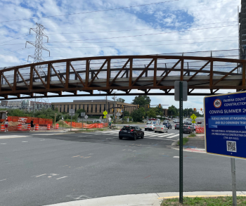
Wiehle Avenue at the W&OD Trail
Mt. Vernon Memorial Highway Trail
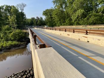
Construction is complete connecting missing links of the trail at George Washington Gristmill to Southwood Drive, including over Dogue Creek.
Silver Line Pedestrian Access Initiatives
The Fairfax County Department of Transportation also is working to improve pedestrian access around the Silver Line Metro stations by implementing the results of several studies.
- Reston Metrorail Access Group (RMAG): Includes pedestrian improvements around the Wiehle Avenue and Reston Parkway Metrorail stations.
- Tysons Metrorail Station Access Management Study (TMSAMS): Includes pedestrian improvements around the four Silver Line Metrorail stations in Tysons.
- Herndon Metrorail Station Access Management Study (HMSAMS): Includes pedestrian improvements around the Herndon and Innovation Metrorail stations.
- Dulles Corridor Bicycle and Pedestrian Improvements (DCBPA): Includes additional pedestrian improvements in areas along the Dulles Road corridor.
Pedestrian Signals
Background
The Board of Supervisors has designated $110 million in federal, state and county funding under direction of FCDOT to construct pedestrian improvements in high-priority areas of Fairfax County. These projects include:
• New crosswalks with pedestrian signals 
• Upgrading existing crosswalks to include pedestrian signals
• Constructing new walkways and trails
• Upgrading existing walkways and constructing ADA accessible curb ramps
• Pedestrian refuge islands
• Decreasing turn radius
• Curb extensions and bulb-outs
• Bus stop improvements
• Yield to Pedestrian Signs
In-Progress and Completed Pedestrian Projects
| IN-PROGRESS INTERSECTIONS/CROSSWALKS |
|
Braddock Road and Guinea Road, add signalized crosswalks, sidewalk southwest to existing Status: Right-of-Way |
| IN-PROGRESS SIDEWALK/TRAIL IMPROVEMENTS |
|
Wakefield Chapel Road east side from Braddock Road to Stahlway Lane Status: Project Initiation |
| IN-PROGRESS BUS STOP IMPROVEMENTS |
|
Burke Lake Road SB at Lake Braddock; install concrete loading pad, bench, trash can Status: Design |
|
Burke Lake Road NB at Lake Braddock; install concrete loading pad, bus shelter pad, bus shelter, bench, trash can Status: Design |
| COMPLETED INTERSECTIONS/CROSSWALKS |
| Backlick Road and Hechinger Drive, add/improve signalized crosswalks |
| Braddock Road and Wakefield Chapel Road, add/improve signalized crosswalks |
| Rolling Road and Burke Road, add signalized crosswalk |
| Braddock Road and Olley Lane, add/improve signalized crosswalks |
| Burke Lake Road and Coffer Woods Road, add/improve signalized crosswalks Extend sidewalk 600 feet |
| Lakepointe Drive and Guinea Road, add/improve signalized crosswalks Extend sidewalk on Lakepoint Drive |
| COMPLETED SIDEWALK/TRAIL IMPROVEMENTS |
| Rolling Road Walkway; sidewalk along NB side between Roxbury Avenue and Tuttle Road |
| Burke Center Parkway south side from Pond Spice Lane to Terra Centre Elementary School |
| Roberts Road west side from Braddock Road to Shenandoah Lane |
| Pohick Stream Valley from Burke Centre VRE to Burke Village missing links |
| Braddock Road north side from Ravensworth Road to I-495 |
| Route 236 from Heritage/Hummer to I-495 |
| Burke Commons Road north side from Meredith Circle to Roberts Parkway |
| Cross County Trail pavement upgrade between Route 236 and Braddock Road |
| Old Keene Mill Road north side from Carrleigh Parkway west to existing sidewalk |
| Burke Centre VRE Connector Phase IV |
| IN-PROGRESS INTERSECTIONS/CROSSWALKS |
|
Balls Hill Road and Old Dominion Drive; intersection improvements Status: Design |
|
Westmoreland Street and Hopewood Drive; install crosswalk and median refuge Status: Design |
| IN-PROGRESS SIDEWALK/TRAIL IMPROVEMENTS |
|
Chesterbrook Road walkway on southside from Maddux Lane to 41st Street Status: Design |
|
Magarity Road walkway from Ware Road to Peabody Drive Status: Design |
|
Lisle Avenue sidewalk along east side from Griffith Road to Sportsman Drive Status: Construction |
|
Great Falls Street sidewalk along west side from Haycock Road to Grande Lane Status: Survey |
|
Ingleside Avenue walkway from McLean Community Center to Churchill Road Design |
|
Rock Hill Road sidewalk from Sterling to Astoria, including culvert installation and retaining wall Status: Construction |
|
Kirby Road sidewalk along east side from Mori to Chesterbrook Status: Utility Relocation |
|
Innovation Station North Neighborhood; add shared-use path and lighting between Innovation Center Metrorail Station Kiss-and-Ride lot, Farougi Court and Apgar Place Status: Design |
|
Beverly Road pedestrian improvements at Old Dominion Drive; 10-foot trail and curb ramp Status: Design |
|
Elm Street pedestrian improvements at Chain Bridge Drive, install sidewalk and curb ramps Status: Design |
|
Kirby Road Walkway between Chesterbrook Elementary School and Halsey Road Status: Construction |
|
Kirby Road Walkway between Halsey Road and Franklin Avenue Status: Construction |
|
Westmoreland Street Walkway between Kirby Road and Lemon Road Status: Design |
|
Route 7 Shared Use Paths, both sides from DTR Bridge to Beulah Road Status: Design |
| IN-PROGRESS BUS STOP IMPROVEMENTS |
|
Chain Bridge Road NB at Brawner Street; bus shelter replacement Status: Construction |
|
Westmoreland Street NB at Hopewell Drive; add bus pad at NE corner Status: Land Acquisition |
|
Elden Street SB at Alabama Drive; add bus pad, shelter. bench and trash can Status: Construction |
| COMPLETED INTERSECTIONS/CROSSWALKS |
| Centreville Road and Dulles Toll Road Ramps, add signalized crosswalk |
| Chain Bridge Road and Tennyson Drive, add signalized crosswalks |
| Route 123 and Great Falls Street, add signalized crosswalk |
| Georgetown Pike and Balls Hill Road, add signalized crosswalk |
| Great Falls Street and Haycock Road, add/improve signalized crosswalks |
| Route 7 and Dranesville Road, add signalized crosswalks |
| Route 7 and Magarity Road, add/improve signalized crosswalks |
| Lewinsville Road and Balls Hill Road, add signalized crosswalk |
| Old Dominion Drive and Whittier Avenue, add signalized crosswalks |
| Route 123 and Churchill Road, add signalized crosswalks |
| Route 7 and Baron Cameron Avenue, add signalized crosswalk |
| Route 7 and Lewinsville Road, add signalized crosswalk |
| Walker Road south of Georgetown Pike, road diet and crosswalk |
| Route 7 and Colvin Run Road East, add signalized crosswalk |
| Westmoreland Street and Old Chesterbrook Road, crosswalks |
| Old Dominion Drive/Linway Terrace/Birch Road, pedestrian improvements |
| Georgetown Pike at Dolley Madison Boulevard, pedestrian improvements |
| COMPLETED SIDEWALK/TRAIL IMPROVEMENTS |
| Lewinsville Road, south side from Altamira Court to Woodhurst Boulevard |
| Lewinsville Road, north side from Windy Hill Road to Scotts Run Road |
| Lewinsville Road, pedestrian safety median at Spring Hill Elementary School |
| Powhatan Street, north side from Orland Street to Overbrook Street |
| Raymond Avenue, east side from Churchill Road to Capital View Drive |
| Spring Hill Road, east side from Old Dominion Drive to Pettit Court missing links |
| Westmoreland Street, west side from Haycock Road to Temple Rodef Shalom |
| Westmoreland Street, west side from Temple Rodef Shalom to Chesterbrook Presbyterian Church |
| Dead Run Drive, south side from Carper Street to Congress Lane |
| Lewinsville Road, south side from Snow Meadow Lane to Elsinore Avenue |
| Baron Road Walkway from Douglass Drive to the Dead Run Trail |
| Birch Street, west side from Grove Avenue to existing Falls Church sidewalk |
| Dolley Madison Boulevard, from Great Falls St/Lewinsville Road to McLean Metro Station |
| Georgetown Pike, from Utterback Store Road to Falls Chase Court |
| Great Falls Street, complete missing sidewalks |
| North West Street, north side from Great Falls Street to Brilyn Place - complete missing sidewalks |
| Kirby Road, south side from Chesterbrook Elementary School to Halsey Road |
| Kirby Road, south side from Halsey Road to Franklin Avenue |
| Kirby Road, Birch to Ivy Hill |
| Kirby Road, Ivy Hill to Corliss |
| Dolley Madison Boulevard, south side from Chain Bridge Road to bus stop east of Kurtz Road |
| Dolley Madison Boulevard, south side missing links from Old Dominion Drive to Beverly Avenue |
| Kirby Road, north side from Chesterbrook Pool to east of Chesterbrook Elementary School |
| Sunrise Valley Drive, east side from River Birch Road to Legacy Circle |
| Innovation Station path, north side of the Dulles Toll Road |
| Georgetown Pike, between Falls Chase Court and Falls Bridge Lane; then Falls Bridge Lane to Seneca Road |
| IN-PROGRESS INTERSECTIONS/CROSSWALKS |
|
Sunrise Valley Drive; crosswalk on east leg of Reston Association entrance Status: Construction |
|
Monroe Street and SVD intersection; upgrade curb ramps, crosswalks, pedestrian push buttons on all four approaches Status: Construction |
|
Wolftrap Elementary School SRTS; protected crosswalk at Beulah Road and Talisman Drive Status: Design |
|
Wiehle Avenue at W&OD Trail; bike and pedestrian grade separated crossing Status: Utility Relocation |
|
Wiehle Avenue and W&OD Trail Phase II grade separation Status: Utility Relocation |
| IN-PROGRESS SIDEWALK/TRAIL IMPROVEMENTS |
|
Fox Mill Road Walkway on northsid; to include curb and gutter Status: Construction |
|
Bluemont Way sidewalk; from Discovery Street Ped Bridge Walkway to Reston Parkway Status: Design |
|
Fairfax County Parkway Trail; at grade crossing of trail at Dulles Toll Road on-ramp Status: Design |
|
Sunrise Valley Drive Walkway; Hitchcock Drive to Colts Brook Drive Status: Post-Construction |
|
Old Courthouse Road; realign to eliminate sharp curve and relocate Besley Road intersection including new bridge, bicycle lanes, shared-use path Status: Utility Relocation |
|
Creek Crossing Road east side; replace sidewalk and fill in missing sidewalk connections from Fairway Drive to Old Courthouse Road Status: Design |
|
Monroe St. Walkway; Fox Mill to Sunrise Valley to complete missing links Status: Post-Construction |
|
Sunrise Valley Drive Walkway; improve existing walkway and install missing link on the north side Status: Design |
|
Ashgrove Lane Trail to Western Tysons Status: Design |
| IN-PROGRESS BUS STOP IMPROVEMENTS |
|
Glade Drive NB at Green Range Drive; install concrete bus shelter pad, bus shelter, bench Status: Post-Construction |
|
Wiehle Avenue NB at North Shore Drive; install bus pad, bench, trash, add curb-abutted sidewalk at intersection. Add detectable warning surface to both corners and sidewalk to existing sidewalk Status: Design |
| COMPLETED INTERSECTIONS/CROSSWALKS |
| Centreville Road and Dulles Toll Road Ramps; add signalized crosswalk |
| Centreville Road and Sunrise Valley Drive; add signalized crosswalks |
| Fairfax County Parkway and Fox Mill Road; add signalized crosswalk |
| Raglan Road and Gosnell Road; add/upgrade signalized crosswalks |
| Tyspring Road and Gosnell Road; add/upgrade signalized crosswalks |
| Vale Road and Flint Road; add/upgrade signalized crosswalks |
| Wall Street and Gosnell Road; add/upgrade signalized crosswalks |
| Route 7 and Baron Cameron Avenue; add/upgrade signalized crosswalks |
| Hunter Mill Road and Sunrise Valley Drive; add signalized crosswalks, sidewalk to existing east |
| Route 7 and Gosnell Road; add/improve signalized crosswalks |
| Route 7 and Spring Hill Road; add signalized crosswalks |
| Route 7 and Tyco Road; add signalized crosswalks |
| Wiehle Avenue and Isaac Newton Square South; add/upgrade signalized crosswalks |
| Sunrise Valley Drive and Commerce Park Drive; add/upgrade signalized crosswalks |
| Sunrise Valley and Centennial Park Drive; add/upgrade signalized crosswalks |
| Sunrise Valley Drive/Mercator Drive, USGS; add/upgrade signalized crosswalks |
| Sunset Hills Road and Town Center Parkway; add/upgrade signalized crosswalks |
| Wiehle Avenue and W&OD Trail Phase I; interim crossing improvements |
| Wiehle Avenue and Dulles Toll Road Ramps; add/upgrade signalized crosswalks |
| COMPLETED SIDEWALK/TRAIL IMPROVEMENTS |
| Colts Neck Road east side from South Lakes Drive to Winterthur Lane |
| Fox Mill Road south side from Fairfax County Parkway to Mill Heights Drive |
| Glade Drive north side from Colts Neck Road to Shire Court |
| McLearen Road north side from Quincy Adams Drive to Reston Parkway |
| North Shore Drive north side from Fairway Drive to Hickory Cluster |
| Reston Avenue west side from Southington Lane to Shaker Drive |
| Reston Transit Center Trail |
| Soapstone Drive west side from Sweetbay Lane to Glade Drive |
| Soapstone Drive west side from Sunrise Valley Drive to Hunters Green Court |
| Wiehle Avenue west side from North Shore Drive to Baron Cameron Avenue |
| Wiehle Avenue east side from Chestnut Grove Square to North Shore Drive |
| Wiehle Avenue from Sunrise Valley Drive to Station Entrance |
| Beulah Road alternate sides from Abbotsford Drive to Coral Crest Lane and Clarks Crossing Road |
| Sunset Hills Road from Reston Center to Town Center Parkway |
| Soapstone Drive east side from South Lakes Drive to Snakeden Stream Valley |
| Sunset Hills Road north side from W&OD Trail to Michael Faraday Court |
| Gosnell Road Walkway on east side north of Route 123 |
| Sunrise Valley Drive south side from Soapstone Drive to South Lakes Drive |
| Sunrise Valley Drive north side from Soapstone Drive to South Lakes Drive |
| Vesper Court Trail from Vesper Ct to Route 7 at Spring Hill Road |
| Sunrise Valley Drive south side from Glade Drive to Reston Parkway |
| Glade Drive Walkway north side from Middle Creek Lane to Glade Bank Way |
| Glade Drive Walkway north side from Colts Neck Road to Reston Parkway; south side from Reston Parkway to Freetown Drive |
| IN-PROGRESS INTERSECTIONS/CROSSWALKS |
|
Commerce Street crosswalk between Old Keene Mill Road and Amherst Avenue Status: Pre-Design |
|
Crosswalk with median on east leg of Memorial Street; crosswalk on Donora Drive Status: Post-Construction |
| IN-PROGRESS SIDEWALK/TRAIL IMPROVEMENTS |
|
Telegraph Road Walkway Phase II, Pike Branch to Wilton; fill in missing links/crosswalks/curb ramps Status: Design |
|
Shared-use path north side of Franconia-Springfield Parkway Status: Post-Construction |
|
Cinderbed Bikeway pedestrian/bike improvements; Barry Road to Newington Road, 2 pedestrian bridges Status: Design |
|
2,000 feet walkway along east side S Van Dorn from Oakwood Road to Alexandria City Line Status: Design |
| IN-PROGRESS BUS STOP IMPROVEMENTS |
|
Rose Hill Drive NB at Leewood Drive; bus stop improvements/install shelter/bench/trash can Status: Design |
|
Manchester Lakes Drive SB at Schoonmaker Court; bus stop improvements/install concrete loading pad/shelter/bench/trash Status: Survey |
|
Loisdale Road NB at Loisdale Court; bus stop improvements/install concrete loading pad/bench/trash Status: Survey |
|
Backlick Road NB at Cabin John Road; bus stop improvements/install shelter/bench/trash can Status: Design |
| COMPLETED INTERSECTIONS/CROSSWALKS |
| North Kings Highway pedestrian safety median from Fort Drive to North Metro Entrance |
| Backlick Road between Highland Street and the Beltway overpass: HAWK Signal |
| Highland Street and Backlick Road and Amherst Avenue; add/upgrade signalized crosswalks |
| Route 1 and Belford Drive South; add signalized crosswalks, lighting, bus shelters |
| Route 1 and Frye Road; add signalized crosswalks, lighting, bus shelters |
| Route 1 and Ladson Lane; add signalized crosswalks, lighting, bus shelters |
| Route 1 and Lockheed Boulevard; add/upgrade signalized crosswalks |
| Route 1 and Mohawk Lane; add signalized crosswalks, lighting, bus shelters |
| Route 1 and North/South Kings Highway; add signalized crosswalks, lighting, bus shelters |
| Route 1 and Southgate Drive; add/upgrade signalized crosswalks |
| Franconia Road at Westchester Street; add median refuge |
| COMPLETED SIDEWALK/TRAIL IMPROVEMENTS |
| Franconia Road north side from Governor's Hill Drive to Telegraph Road |
| Franconia Road south side from Governor's Hill Drive to Telegraph Road |
| Route 1 west side at Belle Haven Towers |
| Route 1 west side at Belle Haven Towers (Phase 2) |
| Franconia Road north side from Norton Road to Governor’s Pond Circle |
| Route 1 west side from Roxbury Drive to Russell Road |
| Route 1 west side from Buckman Road to Janna Lee |
| Route 1 west side from Russell Road to Gregory Drive |
| School Street north side from North Kings Highway to Pine Grove Circle |
| Telegraph Road east side from South Kings Highway to Lee District Park |
| South Van Dorn Street and Franconia Road southwest quadrant |
| IN-PROGRESS INTERSECTIONS/CROSSWALKS |
|
N Chambliss Street and Beauregard Street; extend island at intersection, provide RRFB signal Status: Post-Construction |
| IN-PROGRESS SIDEWALK/TRAIL IMPROVEMENTS |
|
Lincolnia Road Sidewalk; connect pedestrian facilities along N Chambliss Street and Lincolnia Road from Lincolnia Senior Center to Linmar Court Status: Construction |
|
Little River Turnpike Walkway; Columbia Road to Mayhunt Court Status: Post-Construction |
|
Little River Turnpike Walkway; Hillbrook Drive to Little River Run Drive Status: Design |
|
Little River Turnpike Walkway; E and W of Roberts Avenue Status: Land Acquisition |
|
Backlick Road Sidewalk; Kandal Court to Cindy Lane Status: Bid Advertisement |
|
Peace Valley Lane Walkway; Diamond Drive to Mansfield Road, near Justice High School Status: Design |
|
NB side of Backlick Road between Hechinger Drive and Industrial Road; pedestrian improvements Status: Design |
|
Columbia Pike Streetscapes Phase I; sidewalk south side from Backlick Road to Tom Davis Drive Status: Design |
|
Status: Bid Advertisement |
|
Backlick Road east side opposite Wilburdale community Status: On Hold |
| IN-PROGRESS BUS STOP IMPROVEMENTS |
|
Little River Turnpike EB at Oasis Drive; new bus pullout, loading pad, shelter, trash can Status: Design |
|
Carlin Springs Road NB, North of 7-11; Loading pad, sidewalk with drainage improvements Status: Land Acquisition |
|
Carlin Springs Road NB at Columbia Pike; loading pad, sidewalk with drainage improvements Status: Land Acquisition |
|
Patrick Henry Drive NB at Greenwood Drive; loading pad with shelter, bench, trash, detectable warning surface Status: Design |
|
Patrick Henry Drive NB at Brook Drive; loading pad with bench, trash, sidewalk, detectable warning surface Status: Land Acquisition |
|
Columbia Pike WB at John Marr Drive; loading pad with shelter, bench, trash, detectable warning surface Status: Design |
|
John Marr Drive NB at Tom Davis Drive; loading pad w two shelters, benches, trash, sidewalk Status: Survey |
| COMPLETED INTERSECTIONS/CROSSWALKS |
| Backlick Road and Hechinger Drive; add/improve signalized crosswalks |
| Little River Turnpike and Backlick Road; add/improve signalized crosswalks |
| Little River Turnpike and Braddock Road; add/improve signalized crosswalks |
| Route 7 and Glen Carlyn Road; improve signalized crosswalk, relocate with two bus shelters |
| Route 7 and Patrick Henry Drive; add/improve signalized crosswalks, relocate with two bus shelters |
| Route 7 and Route 7/Seminary Road Service Road; add crosswalk |
| Route 7 and South Jefferson Street; add/improve signalized crosswalks |
| Route 50 and Annandale Road; add/improve signalized crosswalks |
| Route 50 and Graham Road; add/improve signalized crosswalks |
| Route 50 and Olin Drive Frontage Road; add/improve signalized crosswalks, relocate bus shelter |
| Route 50 and Patrick Henry Drive; add/improve signalized crosswalks |
| Route 7 and Seven Corners Center; add signalized crosswalk |
| Route 7 and Charles Street; add signalized crosswalks |
| Route 7 and Church Street; add signalized crosswalk |
| Route 7 and Glen Forest Drive; add signalized crosswalks |
| Route 7 and Glenmore Drive; add crosswalk |
| Route 7 and Gorham Street; add crosswalk across Gorham Street (south leg) |
| Route 7 and Nevius Street; add/improve signalized crosswalks |
| Route 7 and Route 50 Interchange ramps; add signalized crosswalks |
| Route 7 and Row Street; add crosswalk |
| Route 7 and South Fourteenth Street; add crosswalk across South Fourteenth Street (north leg) |
| Route 7 and Thorne Road/Castle Road; add signalized crosswalks |
| Annandale Road and Graham Road; add/upgrade signalized crosswalks |
| Backlick Road and Edsall Road; add/upgrade signalized crosswalks |
| Columbia Pike and John Marr Drive; add/upgrade signalized crosswalks |
| Columbia Pike and Gallows Road; add/upgrade signalized crosswalks |
| Route 50 and Allen Street; add/improve signalized crosswalks and bus stop improvements |
| Route 50 and Wayne Road; add/improve signalized crosswalks |
| COMPLETED SIDEWALK/TRAIL IMPROVEMENTS |
| Backlick Road west side from Wilburdale community to Braddock Road |
| Columbia Pike south side from Downing Street to Lincolnia Road |
| Columbia Pike south side from entrance to Holmes Run Stream Valley Park of Powell Lane |
| Lincolnia Road north side from Deming Avenue to North Chambliss Street |
| Montrose Street west side from Braddock Road to Grafton Street missing links/upgrade |
| Route 7 across property of First Christian Church of Falls Church and a bus pad |
| Route 7 south side from east of Patrick Henry Drive across Church Frontage to end of Service Road |
| Tyler Street east side from Columbia Pike to Lake Street |
| Route 7 south side from Gorham Street to South 14th street |
| Columbia Pike north side from Maple Court to Blair Road |
| Columbia Pike south side from Gallows Road to Annandale Methodist Church entrance |
| Elmdale Road south side from Braddock Road to Old Columbia Pike |
| Route 7 south side from west of Rio Drive to Glenmore Drive |
| Route 7 north side from shopping center entrance east of Magnolia Avenue to Payne Street |
| Route 7 south side from Columbia Pike along On-Ramp to Seminary Road |
| Medford Drive Walkway east side from Davian Drive to Four Year Run |
| Route 7 north side from Row Street to west of Nevius Street |
| Route 7 north side from east of Glen Carlyn Road to Magnolia Avenue |
| Route 7 south side from shopping center entrance east of Glen Carlyn Road to Glen Carlyn Drive |
| Route 7 north side from east of Church Street along Columbia Pike Ramp to Columbia Pike |
| Route 7 Service Road north side from Seminary Road to Route 7 |
| Route 7 south side from Service Road to Carlin Springs Road |
| Route 7 north side from South George Mason Drive to South Fourteenth Street |
| Route 7 north side from end of Service Road to Row Street |
| Route 50 south side from Graham Road to Wayne Road |
| Route 50 north side from Woodlawn Avenue to Church |
| Route 50 south side from South Street to Aspen Lane |
| Route 50 south side from Patrick Henry Drive to Olin Drive |
| McWhorter Place Trail |
| IN-PROGRESS INTERSECTIONS/CROSSWALKS |
|
Pole Road; add median refuge island and improve pedestrian crosswalks and curb ramps Status: Land Acquisition |
|
Add left turn lane on EB Terminal Road at the intersection of Fairfax County Parkway Status: Utility Relocation |
| IN-PROGRESS SIDEWALK/TRAIL IMPROVEMENTS |
|
Construct a shared-use-path along Gunston Road from Pohick Bay Golf Course to Julia Taft Way; to include ADA ramps, crosswalks, retaining wall, major drainage and grading work Status: Survey |
|
Complete missing links of trail at entrance of George Washington's Distillery and Gristmill to Southwood Drive; includes bridge over Dogue Creek Status: Construction |
|
Giles Run access road improvement; add trail between Lorton Road and the Laurel Hill Adaptive Rescue Development Status: Design |
|
Cinderbed Road bikeway from Barry Road to Newington Road; to include two pedestrian bridges Status: Design |
|
Route 1 west side from Dogue Creek to Mobile Home Park Status: Project Initiation |
| IN-PROGRESS BUS STOP IMPROVEMENTS |
|
Mt. Vernon Memorial Highway EB at Old Mt. Vernon Road; installed loading pad, sidewalk, curb/gutter/handicap ramps along with drainage and grading work Status: Post Construction |
|
Pole Road SB at Orville Street; install loading pad, drainage improvements Status: Design |
|
Rolling Road NB at Edinburgh Drive; installed shelter, bench, trash can Status: Post Construction |
|
Parkers Lane NB at Sherwood Hall Lane; install loading pad, bus shelter pad, bus shelter, bench, trash can Status: Design |
|
Richmond Highway NB at Woodlawn Trail; install shelter pad with bench, trash can, grading Status: Construction |
|
Arlington Drive EB at Richmond Highway; install loading pad with bench, sidewalk along with grading Status: Survey |
|
Huntington Avenue EB at Hunting Creek Road; install loading pad, shelter, bench, trash can, sidewalk with grading Status: Survey |
|
Sherwood Hall WB at Richmond Highway; add loading pad, bench, sidewalk with grading Status: Survey |
| COMPLETED INTERSECTIONS/CROSSWALKS |
| Route 1 and Engleside Post Office; pedestrian safety median |
| Route 1 and Mount Vernon Memorial Highway; add signalized crosswalk |
| Route 1 and Backlick Road; add/improve signalized crosswalks |
| Route 1 and North/South Kings Highway; add signalized crosswalks, lighting, bus shelters |
| Route 1 and Arlington Road; add/upgrade signalized crosswalks |
| Route 1 and Belford Drive South; add signalized crosswalks, lighting, bus shelters |
| Route 1 and Frye Road; add signalized crosswalks, lighting, bus shelters |
| Route 1 and Ladson Lane; add signalized crosswalks, lighting, bus shelters |
| Route 1 and Lockeed Boulevard; add/upgrade signalized crosswalks |
| Route 1 and Lukens; add signalized crosswalks, lighting, bus shelters |
| Route 1 and Mohawk Lane; add signalized crosswalks, lighting, bus shelters |
| Route 1 and Mount Vernon Highway/Buckman Road; add signalized crosswalks |
| Route 1 and Sacramento Drive/Cooper Road; add/upgrade signalized crosswalks |
| Route 1 and Southgate Drive; add/upgrade signalized crosswalks |
| Hooes Road and Newington Forest Avenue; add/upgrade signalized crosswalks and extend sidewalk |
| Pohick Road and Southrun Road; add/upgrade signalized crosswalks |
| COMPLETED SIDEWALK/TRAIL IMPROVEMENTS |
| Old Mount Vernon Road sidewalk on west side from Mt. Vernon Highway to Westgate Drive |
| Old Mill Road north side from Falkstone Lane to McNair Drive |
| Quander Road west side from Beacon Hill Road to West Potomac High School |
| Route 1 east side from south of Sherwood Hall Lane to Gum Springs Center |
| Route 1 east side south and north of Quander Road |
| Route 1 west side from Dogue Creek to Sacramento Center |
| Route 1 east side from Dart Drive to Grand View Drive |
| Route 1 west side at Belle Haven Towers |
| Route 1 west side from Sacramento Drive to Engleside Plaza (North of Woodlawn Court) |
| Route 1 west side south of Sky View Drive |
| Route 1 east side north of Reddick Avenue/Russell Road |
| Route 1 east side from south of Kings Village Road |
| Route 1 east side from south of Fordson Road to Woodlawn Trail |
| Route 1 east side south of Quander Road (Phase 2) |
| Silverbrook Road north side from Southrun Road to Monacan Road missing links |
| Silverbrook Road Walkway north side from Silverthorn Road to Bayberry Ridge Road |
| Mason Neck Trail, Gunston Road from Pohick Bay Drive to the Pohick Bay Golf Course entrance |
| Mount Vernon Highway west side from Route 1 to retail north of Sunny View Drive |
| Sydenstricker Road north side from Briarcliff Drive to Galgate Drive |
| Route 1 west side from Belle Haven Towers to Mount Eagle Drive |
| Route 1 east side from Engleside Plaza to Forest Place |
| Route 1 east side from Fairhaven Avenue/Quander Road to hotels |
| Route 1 east side from Radford Avenue to Frye Road |
| Route 1 west side from Russell Road to Gregory Drive |
| Route 1 east side north of Janna Lee Avenue to Buckman Road/Mount Vernon Highway |
| Route 1 east side from Mt. Vernon Highway/Buckman Road to north of Napper Road |
| Route 1 east side from Virginia Lodge to Huntington Avenue |
| Silverbrook Road Walkway south side from Hooes Road to South County High School |
| IN-PROGRESS INTERSECTIONS/CROSSWALKS |
|
Cedar Lane; median refuge island, crosswalks, curb ramps Status: Design |
|
Electric Avenue/Cedar Lane; add left turn lane, include intersection improvements Status: Project Initiation |
|
Shrevewood Elementary; new marked crosswalks, walkway connections serving Shrevewood Elementary and W&OD trail Status: Design |
| IN-PROGRESS SIDEWALK/TRAIL IMPROVEMENTS |
|
Chain Bridge Road Sidewalk; southside from Courthouse Road to Sutton Road Status: Land Acquisition |
|
Arlington Blvd/Stonehurst Drive(Phase B); sidewalk connection, curb ramp upgrades, crosswalks Status: Construction |
|
Route 50 Sidewalk; Ellenwood Drive to Chichester Lane (Phase A), add new bus pad, curb, ramps, crosswalks, pedestrian signal upgrades Status: Design |
|
Route 50 Sidewalk; Chichester Lane to Cedar Lane Status: Bid Advertisement |
|
Route 50 Sidewalk; Cedar Lane to Prosperity Avenue; add bus stop accessibility improvements Status: Design |
|
Route 50 Sidewall; Bear Branch Pedestrian Bridge Status: Design |
|
Route 50 Sidewalk; Lindenwood Lane to Nutley Street, with signalized crosswalks/wayfinding signs Status: Utility Relocation |
|
Route 50 Sidewalk; Blake Lane to Stonehurst Drive Status: Land Acquisition |
|
Magarity Road Sidewalk; between Ware Road and Peabody Drive on southside, then northside at school Status: Utility Relocation |
|
Idylwood Road north side from I-495 to Shreve Hill Road Status: Design |
| IN-PROGRESS BUS STOP IMPROVEMENTS |
|
Greensboro Drive at Spring Hill Road; Install loading pad Status: Design |
|
Lee Highway WB at Bisvey Drive; install loading pad, bench, sidewalk Status: Design |
| COMPLETED INTERSECTIONS/CROSSWALKS |
| Colonial Lane and Chain Bridge Road; add/improve signalized crosswalks |
| Prosperity Drive and Hilltop Road; add/improve signalized crosswalks |
| Route 7 and Magarity Road; add/improve signalized crosswalks |
| Route 50 and Annandale Road; add/improve signalized crosswalks |
| Route 50 and Graham Road; add/improve signalized crosswalks |
| Seneca Ave/Chain Bridge Road; add/improve signalized crosswalks |
| Westbranch Drive/Jones Branch Drive; add/improve signalized crosswalks |
| Boone Blvd and Aline Avenue; add/improve signalized crosswalks |
| Old Meadow Road and Old Meadow Lane; add/improve signalized crosswalks |
| Solutions Drive/Greensboro Boulevard; add/improve signalized crosswalks |
| Westbranch Drive/Westpark Drive; add/improve signalized crosswalks |
| Gallows Road and Boone Boulevard; add/improve signalized crosswalks |
| Gosnell Road and Old Courthouse Road; add/improve signalized crosswalks |
| International Drive and Greensboro Road; add/improve signalized crosswalks |
| International Drive and Tysons Boulevard; add/improve signalized crosswalks |
| Route 7 and Gosnell Road; add/improve signalized crosswalks |
| Route 7 and Spring Hill Road; add/improve signalized crosswalks |
| Route 7 and Tyco Road; add/improve signalized crosswalks |
| Route 50 and Allen Street; add/improve signalized crosswalks and improve bus stop |
| Route 50 and Wayne Road; add/improve crosswalks and improve sidewalk |
| Old Courthouse Road/Woodford Road; add/improve signalized crosswalks |
| Tysons Boulevard/Galleria Drive; add/improve signalized crosswalks |
| Gallows Road and Gallows Branch Road; add/improve signalized crosswalks |
| COMPLETED SIDEWALK/TRAIL IMPROVEMENTS |
| Annandale Road east side from Brice Street to Falls Church City line |
| Courthouse Road north side from Chain Bridge Road to Oakton Plantation Lane |
| Edgelea Road east side from Oleander Avenue to Courthouse Road |
| Jefferson Avenue south side from Summerfield Road to Marshall Street |
| Route 29 south side between Shreve Road and Fairview Park Drive |
| Sutton Road missing link at Marywood Road |
| Wolftrap Road from Briarcliff Court to George Washington Road missing link |
| Gallows Road north side from I-495 to Mobil Oil entrance |
| Oak Street south side from Sandburg Street to I-495 |
| Aline Avenue South side from Gallows Road and first entrance on Aline Ave |
| Chain Bridge Road both sides from Old Meadow Road to Tysons Boulevard |
| Dolley Madison Boulevard Walkway from Great Falls Street/Lewinsville Road to McLean Metro Station |
| Idylwood Road south side from South side from I-495 to Whitestone Hill Ct |
| Route 7 both sides under Route 123 |
| Route 50 north side from Cedar Hill Road to Allen Street |
| Route 50 north side from Westcott Street to Annandale Road |
| Route 50 north side from Meadow Lane to Linden Lane |
| Scott’s Run Trail through Scott’s Run Park |
| Chain Bridge Road north from Niblick Road to Horseshoe Drive |
| Chain Bridge Road north side from Anderson Road to Colonial Lane |
| Gallows Road and Old Courthouse Road intersection northwest corner |
| Madrillon Road from Gallows Road to Boss Street |
| Route 7 Shared Use Paths both sides from the Dulles Toll Road Bridge to Beulah Road |
| IN-PROGRESS INTERSECTIONS/CROSSWALKS |
|
Orange Hunt Elementary; realign crosswalk, add curb extensions, provide pedestrian refuge island Status: Design |
| IN-PROGRESS SIDEWALK/TRAIL IMPROVEMENTS |
|
Rolling Road Sidewalk; between Roxbury Avenue and Tuttle Road Status: Post Construction |
| COMPLETED INTERSECTIONS/CROSSWALKS |
| Fairfax County Parkway and Old Keene Mill Road; add signalized crosswalk |
| Old Keene Mill Road and Shiplett Boulevard; add/improve signalized crosswalks |
| Old Keene Mill Road and Sydenstricker Road; add/improve signalized crosswalks |
| Rolling Road and Burke Road; add signalized crosswalk |
| Route 50 and Alder Woods Lane; add signalized crosswalks |
| Route 28 and Compton Road; add signalized crosswalks |
| Route 29 and Monument Drive; add signalized crosswalks |
| Route 50 and Majestic Lane; add/improve signalized crosswalks |
| Route 50 and Stringfellow Road; add/improve signalized crosswalks |
| Hunter Village Drive; pedestrian/bike/parking improvements Old Keene Mill Road to Painted Daisy Drive |
| Burke Lake Road and Coffer Woods Road, add/update signalized crosswalks and extend sidewalk |
| Hooes Road and Newington Forest Avenue; add/update signalized crosswalks and extend sidewalk |
| COMPLETED SIDEWALK/TRAIL IMPROVEMENTS |
| Lee Chapel Road Walkway from Burke Lake Road to Britford Drive |
| Lee Jackson Highway south side from Fair Ridge Drive East to Police/Fire Station |
| Silverbrook Road north side from Silverthorn Road to Bayberry Ridge Road |
| Hunter Village Drive Shoulder Widening from Old Keene Mill Road to Painted Daisy Drive |
| Sydenstricker Road north side from Briarcliff Drive to Galgate Drive |
| IN-PROGRESS SIDEWALK/TRAIL IMPROVEMENTS |
|
Shared-use path east side of Pleasant Valley Road from Elklick Run to Dominion Power Lines Status: Design |
|
Route 29 from Stringfellow Road to Prince William County Line Status: Project Initiation |
| BUS STOP IMPROVEMENTS |
|
Park Meadow Drive WB at Meadow Wood Lane; install loading pad, bus, shelter pad, bench, bike rack, trash can Status: Design |