

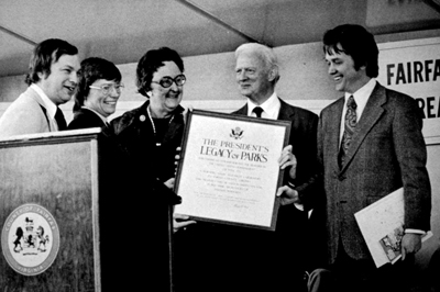
Alert:
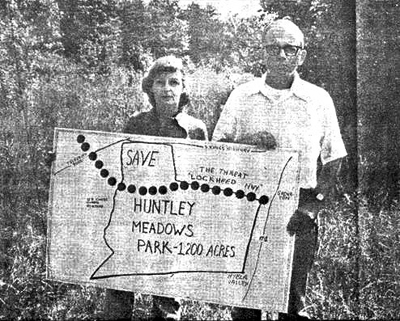 In a 1978 addendum, a map shows a less intrusive alignment for the Lockheed Boulevard road extension. Text in the park’s original master plan indicates that FCPA did not recognize the road. However, that year the FCPA clarified its support of the road as long as certain conditions were met. There were outside pressures requiring the FCPA to add the addendum and support the road. Master Plan development involves public meetings, and while many citizens wanted a road, others such as Norma Hoffman were very much against it. Hoffman and Bob Sawallesh started the Citizen’s Alliance to Save Huntley in 1975. Eventually the organization would have more than 600 members.
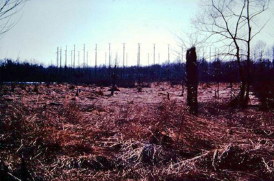 Evidence of past federal use was prominent. The NRL’s Blockhouse had to be taken down. It stood next to the NRL’s access road, which became the park’s Hike-Bike trail.
Also evident was the NRL’s array of antennas at the nearby Coast Guard Station. This double ring of antennae was the first U.S. tracking station to compile data on the path of the Russian satellite Sputnik just five hours after its launch. Sputnik was on its third orbit by then.
Two other NRL antenna arrays were in the park. The most prominent remnants of these arrays are two large circular meadows. The southern-most one is now the park’s central wetland.
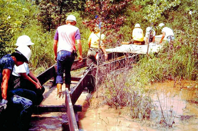 Roisum obtained two grants to construct trails with the help of high school students in the Youth Conservation Corps (YCC) and 16-to-23-year-olds in the Young Adult Conservation Corps (YACC). The boardwalk they built rested on creosote-treated railroad ties. Roisum spoke fondly of those times, and YACC members returned to visit staff years later. There were no other YCC/YACC efforts in the park because the program was cut early in the Reagan administration. President Bill Clinton later instituted Americorps, a similar national volunteer program.
The boardwalk, observation tower, Deer Trail, and Pond Trail were built during this time. The original parking lot sat where the Area III Maintenance material pad now sits. That area previously was part of the Bureau of Public Roads test track in the 1940s. The park’s Lockheed Boulevard entrance and Cedar Trail were constructed in 1983 when the Visitor Center was built.
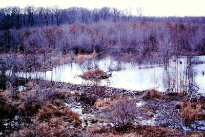 During these early park years, beavers had been constructing a long low dam in the south meadow. By 1981, there was open water habitat. The park’s master plan had called for constructing a water control device or using explosives to accomplish the same thing.
Construction on the visitor center began in 1982. Tons of fill were required due to the high water table. The workmen found old clay pipe in the ground that may have been an old water line. Construction was completed in 1983, and staff began planning, designing and fabricating exhibits.
 Many trail improvements were made in the late 1980s under the direction of Resource Manager Rocky Ventrella. The boardwalk, though, was problematic. These were high water years in the wetlands, and staff frequently had to shim the boardwalk higher and higher until whole sections were floating.
Near the park’s main entrance was a deteriorating house that sparked the interest of the county’s History Commission and citizens led by Norma Hoffman. They applied pressure on elected officials to save the house. Using 1988 bond referendum funds, the house, outbuildings and 2.88 acres were purchased in 1989 for $460,000. So began Park Authority ownership of Historic Huntley, the former home of Thomson Francis Mason. Over the next 20 years there was limited public access to the buildings, which were protected behind a chain link fence. Restoration and site development began in 2010. Historic Huntley officially opened to the public in May 2012.
Also in the 1980s, the informal grassroots organization named the Citizens’ Alliance to Save Huntley incorporated into the Friends of Huntley Meadows Park.
In 1989-1990, the Huntley Meadows Visitor Center was doubled in size and dedicated on October 26, 1990.
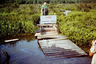
In 1990, after a section of the boardwalk gave way, half of the boardwalk was closed. It was not completely open again until January 1994. Fortunately, in years prior the park manager had requested capital improvement money for boardwalk replacement and wetland restoration.
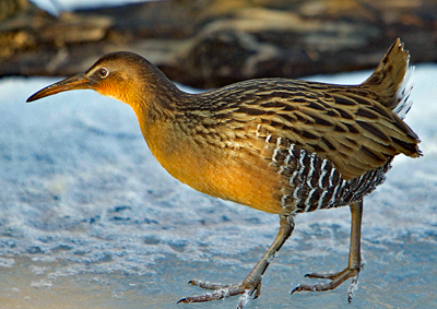 Starting in 1992, several species of locally-rare marsh birds began to disappear from the central wetland. Visitors still saw them during brief migration stops in spring and fall, but they stopped nesting, breeding and raising young in the park. By 1999, staff saw the last recorded successful breeding in the park of Pied-billed Grebe, American Bittern, Least Bittern, Common Moorhen, Yellow-crowned Night Heron, and King Rail. It’s believed that a combination of siltation from local development, decreased water quality, changing water levels from shifting beaver activity, expanding Canada goose populations, decreased crayfish populations, hurricanes and nationwide population declines in wetland birds led to the gradual disappearance of these species as breeders in Huntley Meadows Park. Plans for a wetland restoration project, focused on wildlife habitat improvements, began in this decade with the goal of bringing these marsh birds back.
In 1992, the Fairfax County Park Authority, with financial assistance from Ducks Unlimited, purchased an additional 165 acres of adjacent wetland and upland. Huntley Meadows Park remains a little more than 1,500 acres.
In 1994, the boardwalk was rebuilt with steel anchors, safety railings and a slightly different route. It could now survive storms and changing water levels, hold more visitors, meet Fairfax County building codes, and was fully ADA compliant – the first such wetland boardwalk in Northern Virginia.
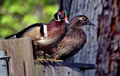
In 1996, hooded mergansers nested in the park’s constructed nest boxes for the first time, joining wood ducks as nesting box tenants. These duck species are tree cavity nesters, living in tree holes usually created and left behind by pileated woodpeckers or storm damage. They also use boxes made to the correct dimensions. At Huntley, volunteers monitor these boxes every year from March-July, helping to make sightings of ducklings and their mothers a common and anticipated spring sight.
By the late 1990s, the park was drawing 100,000 visitors a year.
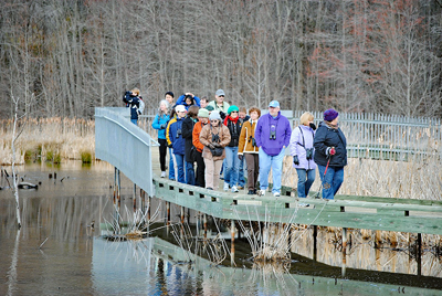
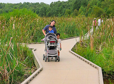 In 2011, the wetland boardwalk and wetlands observation platforms received a face-lift of all new surface boards. The new boards were made from 100% high density poly-ethylene, 90% of which came from one million recycled milk jugs from Chicago. This was the most environmentally-friendly, non-toxic plastic “lumber” product on the market at the time and is common nationwide in parks and wildlife refuges. This large project required one million screws and 1,000 truck trips from the parking lot to the boardwalk. The $600,000 project was funded through a voter-approved 2008 park bond.
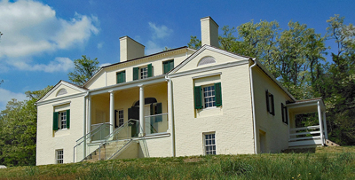 By 2012, it was time for restoration of the historic villa the Park Authority had purchased in 1989. Historic Huntley, a 19th century architectural gem at 6918 Harrison Lane in Alexandria, was owned by Thomson Francis Mason, a five-time mayor of Alexandria and a grandson of George Mason, the author of the Virginia Declaration of Rights. He lived at the villa, which was built for him in 1825. Historic Huntley subsequently was used as a summer retreat, a campsite for troops of the 3rd Michigan infantry during the Civil War and, later, farmland. It is on the National Register of Historic Places, the Virginia Landmarks Register and the Fairfax County Inventory of Historic Sites.